
DJI Phantom 4 RTK w/ Base Station + Case, Extra Batteries & More
Vendor Part Number
B-NB-P4RB
- Everything you need to get reliable, accurate results
- Map up to 3mi² without needing to recharge batteries
- Includes DJI Care Enterprise
- Includes GPC water and dust-proof case
- Up to 2 cm relative vertical accuracy
- Up to 1.20 cm relative horizontal accuracy
- High accuracy with few to no GCPs
- Meets requirements for ASPRS Accuracy Standards for Digital Orthophotos Class Ⅲ
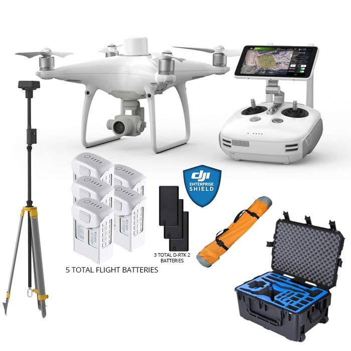
- 1x Phantom 4 RTK
- 1x D-RTK 2 Mobile Station & Tripod
- 1x (Year) DJI Care Enterprise
- 1x Phantom 4 RTK Remote Controller with built-in screen
- 1x GPC Phantom 4 RTK w/ D-RTK 2GroundStation Case
- 1x GPC D-RTK 2 Tripod Bag
- 5x (Total) Phantom 4 Intelligent Flight Battery
- 3x Phantom 4 RTK Remote Controller / D-RTK 2 Mobile Station Battery
- 2x WB37 Battery Charging Hub
- 6x (Total) Pair Propellers
- 1x Battery Charger
- 1x Battery Charging Hub
- 1x MicroUSB Cable
- 1x MicroSD Card
- 1x Gimbal Clamp
AIRCRAFT
- Takeoff Weight: 1391 g
- Diagonal Distance: 350 mm
- Max Service Ceiling Above Sea Leve:l 19685 ft (6000 m)
- Max Ascent Speed: 6 m/s (automatic flight); 5 m/s (manual control)
- Max Descent Speed: 3 m/s
- Max Speed: 31 mph (50 kph)(P-mode) -- 36 mph (58 kph)(A-mode)
- Max Flight Time: Approx. 30 minutes
- Operating Temperature Range: 32° to 104° F (0° to 40℃)
- Operating Frequency: 2.400 GHz to 2.483 GHz (Europe, Japan, Korea) -- 5.725 GHz to 5.850 GHz (United States, China)
- Transmission Power (EIRP): 2.4 GHz CE (Europe) / MIC (Japan) / KCC (Korea) :< 20 dBm -- 5.8 GHz SRRC(China) / FCC(United States)/NCC(Taiwan,China):< 26 dBm
- Hover Accuracy Range: RTK enabled and functioning properly:Vertical:±0.1 m;Horizontal:±0.1 m -- RTK disabled: Vertical:±0.1 m(with vision positioning );±0.5 m(with GNSS positioning)Horizontal:±0.3 m(with vision positioning); ±1.5 m(with GNSS positioning)
- Image Position Offset: The position of the camera center is relative to the phase center of the onboard D-RTK antenna under the aircraft body's axis:(36, 0, and 192 mm) already applied to the image coordinates in Exif data. The positive x, y, and z axes of the aircraft body point to the forward, rightward, and downward of the aircraft, respectively.
MAPPING FUNCTIONS
- Mapping Accuracy **: Mapping accuracy meets the requirements of the ASPRS Accuracy Standards for Digital Orthophotos Class Ⅲ.
** The actual accuracy depends on surrounding lighting and patterns, aircraft altitude, mapping software used, and other factors when shooting. - Ground Sample Distance(GSD): (H/36.5) cm/pixel,H means the aircraft altitude relative to shooting scene (unit: m)
- Data Acquisition Efficiency: Max operating area of approx. 1 km² for a single flight(at an altitude of 182 m, i.e., GSD is approx. 5 cm/pixel, meeting the requirements of the ASPRS Accuracy Standards for Digital Orthophotos Class Ⅲ
VISION SYSTEM
- Velocity Range: ≤31 mph(50 kph) at 6.6 ft(2 m) above ground with adequate lighting
- Altitude Range: 0-33 ft(0 - 10 m)
- Operating Range: 0-33 ft(0 - 10 m)
- Obstacle Sensing Range: 2-98 ft(0.7-30 m)
- FOV: Forward/Rear: 60° (horizontal), ±27° (vertical) -- Downward: 70° (front and rear), 50° (left and right)
- Measuring Frequency: Forward/Rear:10 Hz -- Downward: 20 Hz
- Operating Environment: Surfaces with clear patterns and adequate lighting(> 15 lux)
CAMERA
- Sensor: 1" CMOS; Effective pixels: 20 M
- Lens: FOV 84°;8.8 mm / 24 mm(35 mm format equivalent:24 mm -- f/2.8 - f/11, auto focus at 1 m - ∞
- ISO Range: Video:100-3200(Auto), 100-6400(Manual) -- Photo:100-3200(Auto), 100-12800(Manual)
- Mechanical Shutter Speed: 8 - 1/2000 s
- Electronic Shutter Speed: 8 - 1/8000 s
- Max Image Size: 4864×3648(4:3)-- 5472×3648(3:2)
- Video Recording Modes: H.264,4K:3840×2160 30p
- Photo Format: JPEG
- Video Format: MOV
- Supported File Systems: FAT32(≤ 32 GB)-- exFAT(> 32 GB)
- Supported SD Cards: MicroSD, Max Capacity: 128 GB. Class 10 or UHS-1 rating required Write speed≥15 MB/s
- Operating Temperature Range: 32° to 104° F (0° to 40℃)
INTELLIGENT FLIGHT BATTERY(PH4-5870MAH-15.2V)
- Capacity: 5870 mAh
- Voltage: 15.2 V
- Battery Type: LiPo 4S
- Energy: 89.2 Wh
- Net Weight: 468 g
- Charging Temperature Range: 14° to 104℉(-10° to 40℃)
- Max charging Power: 160 W
INTELLIGENT BATTERY CHARING HUB(WCH2)
- Input Voltage: 17.3 - 26.2 V
- Output Voltage and Current: 8.7 V,6 A;5 V,2 A
- Operating Temperature: 41° to 104℉(5° to 40℃)
GNSS
- Single-Frequency, High-Sensitivity GNSS Module: GPS+BeiDou+Galileo(Asia) -- GPS+GLONASS+Galileo(other regions)
- Multi-Frequency Multi-System High-Precision RTK GNSS - Frequency Used: GPS:L1/L2-- GLONASS:L1/L2 -- BeiDou:B1/B2 -- Galileo:E1/E5a
- First-Fixed Time:< 50 s
- Positioning Accuracy: Vertical 1.5 cm + 1 ppm(RMS)-- Horizontal 1 cm + 1 ppm(RMS)[1 ppm means the error has a 1mm increase for every 1 km of movement from the aircraft.]
GIMBAL
- Stabilization: 3-axis (tilt, roll, yaw)
- Pitch: -90° to +30°
- Max Controllable Angular Speed: 90°/s
- Angular Vibration Range: ±0.02°
INFRARED
- Obstacle Sensing Range: 0.6-23 ft(0.2 - 7 m)
- FOV: 70°(Horizontal) -- ±10°(Vertical)
- Measuring Frequency: 10 Hz
- Operating Environment: Surface with diffuse reflection material, and reflectivity> 8%(such as wall,trees, humans, etc.)
REMOTE CONTROLLER
- Operating Frequency: 2.400 GHz-2.483 GHz(Europe,Japan,Korea) -- 5.725 GHz-5.850 GHz(United States, China)
- Transmission Power (EIRP): 2.4 GHz CE / MIC / KCC:< 20 dBm -- 5.8 GHz SRRC / FCC:< 26 dBm
- Max Transmission Distance: FCC:4.3 mi(7 km) -- SRRC / CE / MIC / KCC:3.1 mi(5 km) (Unobstrcted, free of interference)
- Power Consumption: 16 W(typical value)
- Display: 5.5 inch screen, 1920×1080, 1000 cd/m², Android System -- Memory 4G RAM+16G ROM
- Operating Temperature Range: 32° to 104° F (0° to 40℃)
INTELLIGENT FLIGHT BATTERY CHARGING HUB(PHANTOM 4 CHARGING HUB)
- Voltage: 17.5 V
- Operating Temperature Range: 41° to 104℉(5° to 40℃)
- Capacity: 4920 mAh
- Voltage: 7.6 V
- Battery Type: LiPo 2S
- Energy: 37.39 Wh
- Operating Temperature: -4° to 104℉(-20° to 40℃)
AC POWER ADAPTER(PH4C160)
- Voltage: 17.4 V
- Rated Power: 160 W
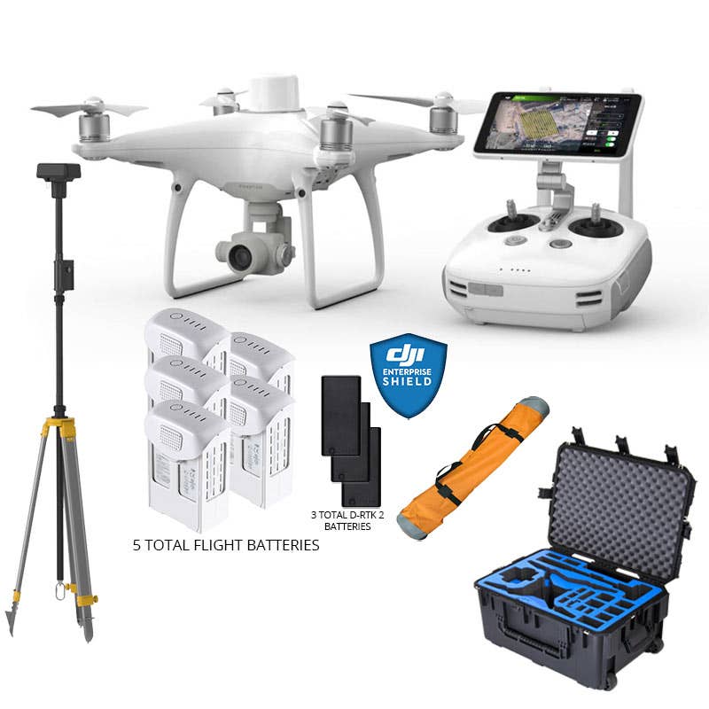
- 1x Phantom 4 RTK
- 1x D-RTK 2 Mobile Station & Tripod
- 1x (Year) DJI Care Enterprise
- 1x Phantom 4 RTK Remote Controller with built-in screen
- 1x GPC Phantom 4 RTK w/ D-RTK 2GroundStation Case
- 1x GPC D-RTK 2 Tripod Bag
- 5x (Total) Phantom 4 Intelligent Flight Battery
- 3x Phantom 4 RTK Remote Controller / D-RTK 2 Mobile Station Battery
- 2x WB37 Battery Charging Hub
- 6x (Total) Pair Propellers
- 1x Battery Charger
- 1x Battery Charging Hub
- 1x MicroUSB Cable
- 1x MicroSD Card
- 1x Gimbal Clamp
Top customer reviews
No reviews
Write Your Own Review