


DJI Matrice 4E Universal Edition
DJI Matrice 4E Universal Edition

Couldn't load pickup availability


- Description
- Specifications
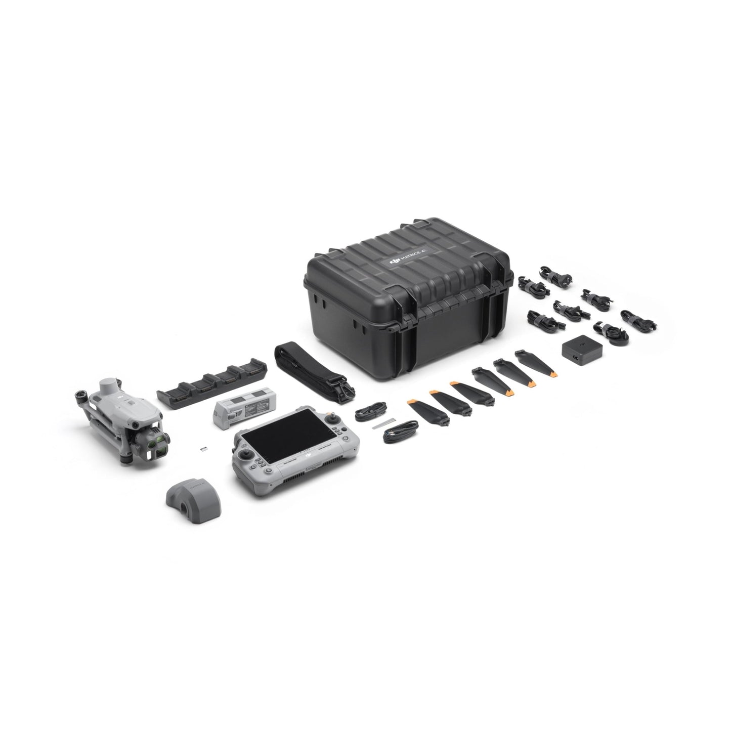
- In the Box
- FAQ
DJI Matrice 4E for Superior Efficiency and Accuracy in Geospatial Operations
The DJI Matrice 4E is an advanced tool for professionals in surveying, mapping, construction, and asset inspection.
Designed to maximize efficiency and accuracy, the Matrice 4E boasts advanced features such as 5-directional oblique capture, distortion correction, and Smart 3D Capture, making it a game-changer for large-scale projects.
With its extended flight time and simplified operations, this drone empowers users to achieve unmatched results in the field.
Boosted Efficiency for Large Projects
-
Extended flight time: Enjoy up to 49 minutes of uninterrupted flight, allowing you to cover more ground with fewer battery changes.
-
High-speed data collection: The Matrice 4E's 0.5-second capture interval accelerates data collection, helping you meet tight project deadlines.
-
5-directional oblique capture: Enhance mapping efficiency by up to 40%, enabling quicker completion of complex projects.
Exceptional Accuracy
-
Distortion Correction 2.0: Reduces residual distortion to less than two pixels, ensuring accurate outputs for even the most demanding mapping scenarios.
-
Pre-calibrated cameras: Factory-calibrated cameras and seamless integration with DJI Terra ensure precision at every stage of the workflow.

Simplified Operations for Complex Tasks
-
Smart 3D capture: Generate detailed 3D models and precise mapping routes directly from the RC Plus 2 controller, streamlining your workflow.
-
Enhanced obstacle avoidance: Operate safely in complex environments, reducing the risk of collisions and ensuring mission success.
Free 1-Year DJI Terra Pro Subscription
The DJI Terra Pro is a professional mapping and reconstruction software developed by DJI, designed to process aerial data into outputs such as 2D orthomosaics, 3D models, and mapping deliverables.
It is commonly used in industries like surveying, construction, agriculture, and infrastructure inspection.
The free 1-year DJI Terra Pro license is a complimentary subscription bundled with the DJI Matrice 4E and is subject to certain limitations compared to full commercial licenses.
Key limitations to be aware of:
-
Drone compatibility:
The license is typically restricted to processing data captured only from the Matrice 4E it was purchased with. Images from other DJI drones or third-party platforms may not be supported. -
Device binding and unbinding:
The license can only be activated on one Windows computer. Once bound, it cannot be transferred or unbound, even if you change or upgrade devices. -
Internet requirement:
A stable internet connection is required during use, as the license relies on online authorization. -
Feature availability:
While it includes core capabilities such as 2D and 3D reconstruction, it does not include certain advanced features like:- Cluster computation (multi-computer processing)
- Selected high-end or specialized tools available in higher-tier DJI Terra licenses
This complimentary license is intended for standard workflows and evaluation use. Users requiring full flexibility, multi-device use, or advanced processing features may need to upgrade to a paid DJI Terra license.
Applications
Surveying and Mapping
-
Large-scale mapping: The Matrice 4E's advanced features make it the perfect choice for surveying firms, planning organizations, and government departments requiring detailed topographic data.
-
Building and land modeling: Create precise 3D models for architectural design, heritage conservation, and urban planning.
Construction and Infrastructure
-
Site modeling: Capture high-resolution data to monitor construction progress, assess topography, and generate actionable insights for infrastructure projects.
-
Asset inspections: Identify defects or structural issues in bridges, buildings, and industrial assets with high-precision cameras.

Geospatial Applications
-
Detailed mapping and inspection: Ideal for mining, forestry, and land management tasks that require accurate mapping and asset evaluation.
Dronefly is committed to providing the highest-quality enterprise drone solutions, backed by fast delivery, expert customer support, and tailored recommendations.
With Dronefly, you're not just purchasing a drone-you're investing in a reliable partner that ensures you achieve the best results in every mission.

