Skip to product information
1 of 6

CHCNAV X500 Professional Multirotor Drone

CHCNAV X500 Professional Multirotor Drone

Regular price $12,699.00
Regular price Sale price $12,699.00
Sale Sold out
  • Heavy-lift enterprise multirotor supports certified CHCNAV payloads
  • Up to 58 minutes maximum flight time
  • Dual hot-swappable intelligent battery system
  • IP55-rated airframe for harsh environments
  • Forward obstacle detection with visual SLAM
  • Redundant GNSS and IMU navigation architecture
  • Long-range HD video transmission capability
  • SmartGo software supports automated mission planning
View full details
  • Description
  • Specifications
  • In the Box
  • FAQ

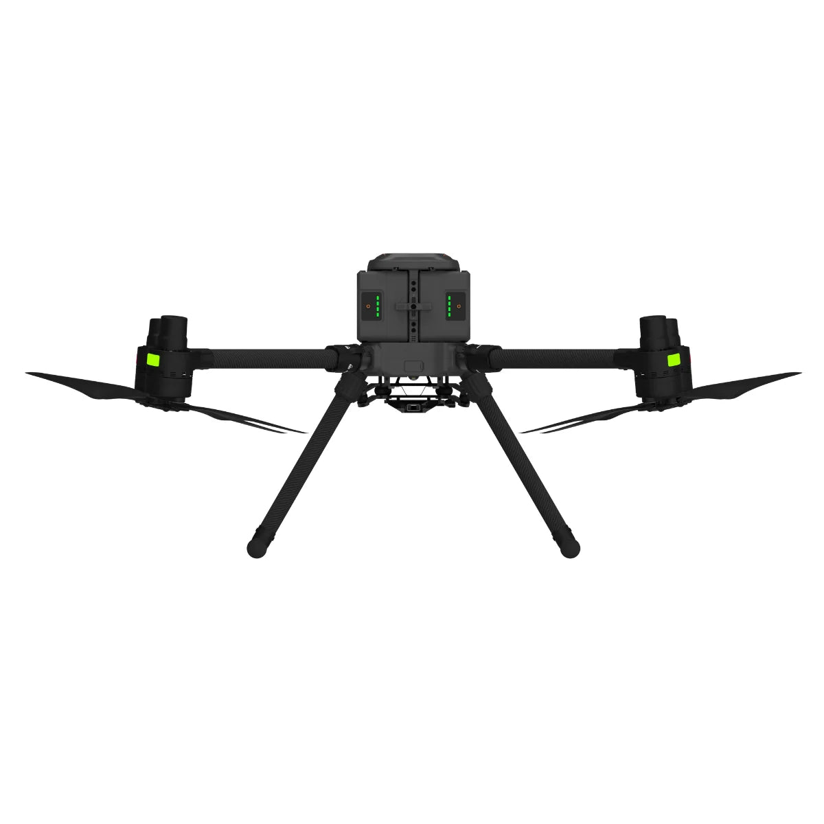
CHCNAV X500 Professional Multirotor Drone: enterprise heavy-lift aerial platform

The CHCNAV X500 Professional Multirotor Drone is an enterprise-grade UAV engineered for heavy-lift operations, extended endurance, and mission reliability. Designed for professional users, the X500 supports certified CHCNAV LiDAR and imaging payloads up to 5 kg while achieving flight times of up to 58 minutes without payload. Its redundant navigation architecture, visual SLAM positioning, and forward obstacle detection enable safe operation in complex environments. With long-range HD video transmission and intelligent battery systems, the X500 is built for surveying, inspection, emergency response, and infrastructure operations.

Core airframe features and mission-ready capabilities

  • Heavy-lift design: Supports certified payloads up to 5 kg
  • Long endurance: Up to 58 minutes flight time without payload
  • Redundant navigation: Dual GNSS and triple IMU configuration
  • Environmental resilience: IP55 protection rating for harsh conditions
  • Obstacle awareness: Forward vision sensor with 80-meter detection range
  • Visual positioning: vSLAM supports precision landings and navigation
  • Power system: Dual hot-swappable intelligent batteries
  • Field logistics: BS10 station enables rapid multi-battery charging
  • Command range: HD video transmission up to 20 km

Redundancy-driven flight stability with visual positioning systems

The X500 integrates multiple redundant subsystems to ensure stable and predictable flight performance across enterprise missions. Dual GNSS receivers and triple IMUs maintain positioning integrity, while dual flight controllers provide fault tolerance. Visual SLAM positioning enhances accuracy during low-altitude or GNSS-limited operations, supporting precise landings on static or moving platforms. Forward obstacle detection actively identifies hazards during automated and manual flights, improving operational safety in urban and industrial environments.

Payload-focused performance with intelligent power management

With a 5 kg payload capacity, the X500 supports certified CHCNAV LiDAR and imaging payloads for long-duration data collection. Dual B10 intelligent batteries allow hot-swap replacement to minimize downtime between sorties. The BS10 intelligent battery station supports six batteries and rapid charging cycles, enabling continuous operations in the field. Combined with SmartGo mission planning and terrain-following flight, the X500 delivers reliable performance for professional aerial workflows.

Certified payloads and system compatibility

  • Supported RGB payloads: CHCNAV C5 and C30 cameras
  • Supported LiDAR payloads: CHCNAV AU20, AA15, AA10, AA9
  • Payload mounting options: Single or dual downward configurations
  • Combined payloads: Single downward with single upward configuration
  • Maximum payload count: Up to three certified payloads
  • SDK support: Certified payload integration via CHCNAV SDK

Professional operations and deployment scenarios

  • Geospatial surveying: Large-area data capture with certified sensors
  • Infrastructure inspection: Power, transport, and industrial assets
  • Emergency response: Rapid aerial situational awareness missions
  • Disaster relief: Damage assessment and operational coordination
  • Urban operations: Obstacle-aware flight in dense environments
  • Mining operations: Surveying and mapping in challenging terrain
  • Environmental monitoring: Long-endurance remote data acquisition
  • Construction monitoring: Progress tracking and site documentation

Engineered for enterprise deployment and operational continuity

The CHCNAV X500 is designed for organizations that require dependable aerial platforms with standardized workflows. Its certified payload ecosystem, redundant flight systems, and SmartGo software enable repeatable operations across teams. With robust environmental protection and efficient battery logistics, the X500 supports sustained enterprise deployment.

The X500 combines payload flexibility, endurance, and safety systems into a single professional platform. Its modular design allows organizations to scale capabilities as mission requirements evolve.

Order from Dronefly today — the West Coast’s trusted enterprise UAV source for professional aerial platforms.

Airframe and Design

  • Aircraft type: Quadcopter with four propellers
  • Structure: Carbon fiber, quick-release design
  • Dimensions (unfolded, without propellers): 770 × 804 × 450 mm (30.3 × 31.7 × 17.7 in)
  • Dimensions (folded, with propellers): 485 × 490 × 450 mm (19.1 × 19.3 × 17.7 in)
  • Diagonal wheelbase: 1000 mm
  • Transport container dimensions: 792 × 520 × 313 mm (31.2 × 20.5 × 12.3 in)

Weights and Payload Capacity

  • Empty weight: Approx. 4.4 kg (without batteries)
  • Empty weight (with single downward gimbal): Approx. 8.9 kg (with two batteries)
  • Maximum payload: 5 kg
  • Maximum takeoff weight: 13.9 kg

Positioning and Hover Accuracy

  • Hovering accuracy (GNSS): Vertical ±0.5 m; Horizontal ±1.5 m
  • Hovering accuracy (RTK): Vertical ±0.1 m; Horizontal ±0.1 m
  • RTK accuracy (RTK FIX): Horizontal 1 cm ±1 ppm; Vertical 1.5 cm ±1 ppm
  • GNSS systems: GPS, GLONASS, BeiDou, Galileo

Flight Performance

  • Maximum ascent speed: 8 m/s
  • Maximum descent speed: 6 m/s
  • Maximum flight speed: 23 m/s
  • Maximum flight time (no payload): 58 minutes
  • Maximum flight time (2 kg payload): 52 minutes
  • Maximum flight time (4 kg payload): 40 minutes

Obstacle Avoidance and Landing Accuracy

  • Ingress protection rating: IP55
  • Obstacle avoidance: Forward obstacle detection sensor
  • Obstacle detection range: 80 m
  • Landing deviation: ≤10 cm (vision positioning); ≤8 cm (RTK fixed)

Environmental Specifications

  • Operating temperature: −20° to 50°C (−4° to 122°F)
  • Storage temperature: −40° to 70°C (−40° to 158°F)

Remote Controller (EC10)

  • Model: EC10
  • Screen: 10.1-inch touchscreen
  • Resolution: 1920 × 1200
  • Maximum brightness: 1000 nits
  • Weight: Approx. 1.5 kg
  • Built-in battery: Li-ion
  • Operating time: Approx. 5 hours
  • Operating temperature: −20° to 50°C (−4° to 122°F)
  • Operating frequency: 2.4015–2.4814 GHz
  • Maximum transmission distance: Up to 20 km (moderate or no wind)

Intelligent Battery (B10)

  • Model: B10
  • Battery type: Li-ion (10000 mAh @ 47.04 V)
  • Energy: 470.4 Wh
  • Weight: Approx. 2.25 kg
  • Operating temperature: −20° to 50°C (−4° to 122°F)
  • Ideal storage temperature: 22° to 30°C (71.6° to 86°F)
  • Charging temperature: −20° to 40°C (−4° to 104°F)
  • Charging time: Approx. 70 minutes (full); approx. 40 minutes (20% to 90%)

Payload Support and Integration

  • Supported payload configurations: Single downward, single upward, dual downward, downward + upward
  • Supported CHCNAV RGB cameras: C5, C30
  • Supported CHCNAV LiDAR payloads: AU20, A15, AA10, AA9
  • Third-party payloads: Supports certified payloads developed using the CHCNAV SDK

Intelligent Battery Station (BS10)

  • Model: BS10
  • Size: 576 × 372 × 302 mm (22.7 × 14.6 × 11.9 in)
  • Net weight: Approx. 9.9 kg
  • Compatible stored items: Six B10 intelligent flight batteries
  • Input voltage: 100–120 VAC or 220–240 VAC, 50–60 Hz
  • Maximum input power: 1200 W
  • Output power: 1000 W
  • Operating temperature: −20° to 40°C (−4° to 104°F)
  • 1x X500 Airframe
  • 1x EC10 Remote Controller
  • 1x Landing Gear
  • 1x Extra Propeller Set
  • 2x B10 Intelligent Batteries
  • 1x BS10 Battery Charging Station
  • 1x Transport Case
What payloads work with the CHCNAV X500 Professional Multirotor Drone?

The X500 supports certified CHCNAV payloads including C5, C30, AU20, AA15, AA10, and AA9. Only certified payloads are supported.

How long does the CHCNAV X500 Professional Multirotor Drone fly per battery set?

Flight time reaches up to 58 minutes without payload, decreasing with payload weight.

Does the CHCNAV X500 Professional Multirotor Drone allow battery hot swapping?

Yes. Dual B10 intelligent batteries support hot-swap replacement during operations.

Is the CHCNAV X500 Professional Multirotor Drone suitable for harsh environments?

The drone carries an IP55 rating and operates from −20 °C to 50 °C.

What control software is used with the CHCNAV X500 Professional Multirotor Drone?

The aircraft is operated using CHCNAV SmartGo ground control software.