Skip to product information
1 of 7

DJI Matrice 400

DJI Matrice 400

Regular price $10,450.00
Regular price Sale price $10,450.00
Sale Sold out
SKU S-DJI-M400 MPN CP.EN.00000667.01 EAN 6937224120570 UPC 190021146051
  • Does not include DJI Care Enterprise Plan but is eligible for Dronefly Care Plus Extended Warranty (sold separately)
  • Enterprise flagship platform with 59-minute forward flight time payload-equipped.
  • Six-kilogram payload capacity with up to seven simultaneous payloads.
  • Rotating LiDAR with 360° horizontal FOV at 520,000 points per second.
  • Six-direction mmWave radar for all-weather power line detection.
  • O4 Enterprise 40km transmission with built-in airborne relay capability.
  • IP55 rated for operations from -20°C to 50°C in harsh environments.
  • RTK positioning with 1 cm horizontal accuracy and ADS-B In onboard.
  • Ship-based takeoff and landing on moving vessels up to 10 knots.
  • Compatible with Zenmuse H30T, L2, L3, and P1 payload systems.
Add Dronefly Care Plus Extended Warranty Coverage
View full details
  • Description
  • Specifications
  • In the Box
  • FAQ

DJI Matrice 400: Multi-Payload Enterprise Drone Platform With Rotating LiDAR and 40 km O4 Transmission

The DJI Matrice 400 establishes a new capability baseline for enterprise drone operations. Launched in June 2025 as DJI's flagship industrial platform, it combines 59 minutes of forward flight endurance, a 6 kg payload capacity, and an obstacle sensing system built around rotating LiDAR and six-direction mmWave radar—delivering power-line-level detection at speeds up to 25 m/s in conditions ranging from clear skies to rain, fog, and total darkness.

For fleet operators, systems integrators, and enterprise program managers evaluating heavy-lift platforms for inspection, mapping, emergency response, and corridor operations, the M400 raises the operational ceiling across every key performance metric.

Key Features and Benefits

  • 59-minute flight time: forward endurance measured with H30T payload at sea level, no wind.
  • 6 kg payload: four E-Port V2 ports support up to seven simultaneous mounted payloads.
  • Rotating LiDAR: 360° horizontal, 58° vertical sensing at 520,000 points per second.
  • mmWave radar: six-direction all-weather power line detection up to 50 m range.
  • 40 km O4 transmission: 3-channel 1080p live view with built-in airborne relay capability.
  • RTK accuracy: 1 cm + 1 ppm horizontal with dual-antenna ADS-B In up to 20 km.
  • IP55 rated: operational from -20°C to 50°C in dust, rain, and offshore environments.
  • 7,000 m ceiling: supports operations in high-altitude and mountainous terrain conditions.
  • Ship-based operations: takeoff from static vessels, landing on moving vessels up to 10 knots.
  • Full SDK access: Payload SDK, Mobile SDK, Cloud API, and FlightHub 2 integration supported.

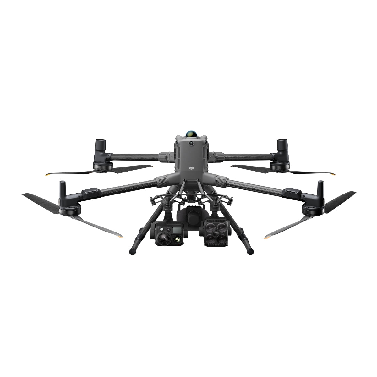
The M400's architecture is designed for configurability at scale. Four external E-Port V2 ports support up to seven simultaneous payloads with a combined 6 kg capacity, accommodating single or dual downward gimbal configurations alongside topside accessories including the Manifold 3 onboard computer.

The DJI O4 Enterprise Enhanced Video Transmission system delivers 3-channel 1080p/30fps live view at up to 40 km (FCC) with a built-in airborne relay module that extends signal coverage across obstructed terrain by using one M400 to relay for another.

RTK positioning achieves 1 cm + 1 ppm horizontal accuracy, and dual DJI Cellular Dongle 2 support enables automatic carrier network switching for continuous connectivity in remote or interference-prone environments. Batteries and battery station are sold separately.

A Platform Architecture Built for Fleet-Level Deployment

For enterprise programs deploying multiple aircraft across distributed operations, the M400's design decisions compound. The O4 Enterprise Enhanced system's airborne relay capability eliminates the signal range limitations that obstructed terrain typically imposes — one M400 can relay transmission for a second M400, significantly expanding operational reach in mountain ranges, urban canyons, and corridor environments without additional ground infrastructure.

The RC Plus 2 controller's 7.02-inch, 1,400 nit display supports full mission management in direct sunlight, with 3.8 hours of internal battery runtime and optional WB37 external battery extension. DJI FlightHub 2 integration enables remote fleet control of flights, gimbal cameras, PSDK accessories, and route functions from a centralized platform, reducing the per-aircraft operator overhead for large-scale or multi-site deployments.

The M400's open SDK ecosystem — Payload SDK, Mobile SDK, and Cloud API — supports custom workflow integration without requiring proprietary middleware.

DJI Matrice 400 being flown in rugged environment

Compatibility and System Integration

  • Zenmuse H30 and H30T: five-sensor all-weather payload with wide-angle, zoom, thermal, laser rangefinder, and NIR light.
  • Zenmuse L2: frame-based LiDAR with high-accuracy IMU and 4/3 CMOS RGB mapping camera.
  • Zenmuse L3: LiDAR payload for high-density geospatial data acquisition missions.
  • Zenmuse P1: full-frame photogrammetry payload with interchangeable fixed-focus lenses.
  • D-RTK 3 Multifunctional Station and D-RTK 2 Mobile Station: RTK correction for centimeter-level positioning.
  • Manifold 3: onboard edge computing for AI inference and autonomous mission processing.
  • DJI FlightHub 2: centralized fleet management, remote mission control, and payload operation platform.
DJI Matrice 400 flying at night with spotlight and camera payload

Applications and Use Cases

  • Power line and corridor inspection: rotating LiDAR and mmWave radar maintain safety at operational speeds.
  • Emergency response and SAR: 59-minute endurance and thermal imaging support extended search coverage.
  • Large-area mapping and LiDAR survey: Zenmuse P1 and L2 deliver photogrammetry and point cloud data at scale.
  • Offshore and maritime inspection: ship-based operations support wind turbine and maritime patrol missions.
  • Firefighting and disaster response: IP55 protection and wide temperature range sustain operations in extreme conditions.
  • Multi-payload inspection workflows: simultaneous sensor configurations reduce required flight passes per site.
  • Autonomous fleet operations: FlightHub 2 and SDK support enable remote and automated multi-aircraft deployment.

The M400 answers the platform question that enterprise drone programs keep arriving at: when a mission requires extended endurance, heavy payload capacity, all-weather obstacle avoidance, and long-range transmission in a single aircraft, what do you deploy?

For inspection programs managing power infrastructure, survey teams covering large corridors, and emergency response organizations that need persistent aerial capability in conditions other platforms cannot sustain, the Matrice 400 is the answer.

Dronefly has spent years building UAV solutions partnerships with enterprise operators across inspection, public safety, and geospatial programs, and the DJI Matrice 400 represents the kind of platform-level capability those partnerships are built to support.

When you source the M400 through Dronefly, you gain access to payload configuration guidance, fleet deployment consultation, and the procurement expertise to build a complete M400 system—aircraft, payloads, batteries, and charging infrastructure — matched to your operational requirements. 

Reach out to Dronefly today to discuss how the Matrice 400 fits your program.

Aircraft

  • Takeoff Weight (with propellers): Without Batteries: 5020 ± 20 g; With Batteries: 9740 ± 40 g 
  • Max Takeoff Weight: 15.8 kg
  • Dimensions: Unfolded: 980×760×480 mm; Folded: 490×490×480 mm; Carrying Case: 779×363×528 mm
  • Max Payload: 6 kg
  • Propeller Size: 25 inches
  • Diagonal Wheelbase: 1070 mm
  • Max Ascent Speed: 10 m/s
  • Max Descent Speed: 8 m/s
  • Max Horizontal Speed: 25 m/s
  • Max Takeoff Altitude: 7000 m
  • Max Flight Time: 59 minutes
  • Max Hover Time: 53 minutes
  • Max Flight Distance: 49 km
  • Max Wind Resistance: 12 m/s
  • Max Yaw Angular Velocity: 100°/s
  • Max Pitch Angle: 35°
  • Operating Temperature: –20° to 50 °C
  • GNSS: GPS + Galileo + BeiDou + GLONASS*
  • Hovering Accuracy:

    Vertical: ±0.1 m (vision), ±0.5 m (satellite), ±0.1 m (RTK)
    Horizontal: ±0.3 m (vision), ±0.5 m (satellite), ±0.1 m (RTK)

  • RTK GNSS Accuracy: 1 cm + 1 ppm (H), 1.5 cm + 1 ppm (V)
  • RTK Heading: Better than 2°
  • ADS‑B In: Range: 20 km
  • Internal Storage: N/A
  • Ports: USB‑C Debug, E‑Port V2 ×4, Cellular Dongle 2 ×2
  • Propeller Model: 2510F
  • Beacon: Built-in
  • Ingress Protection: IP55

Gimbal

  • Max Payload (Single Connector): 1400 g
  • Max Payload (Dual Connector): 950 g
  • Max Payload (Third Connector): 3 kg (quick‑release), 6 kg (screw lock)

Sensing System

  • Sensors: Omnidirectional binocular vision, LiDAR, infrared, mmWave radar
  • Forward/Backward: Range: 0.4–21 m; Detection: 0.4–200 m; FOV: 90°×90°
  • Lateral: Range: 0.6–21 m; Detection: 0.5–200 m; FOV: 90°×90°
  • Downward: Range: 0.5–19 m; FOV: 160° front/rear, 105° sides
  • Rotating LiDAR: Range: 0.5–100 m; FOV: 360°×58°
  • Upper LiDAR (3D ToF): Range: 0.5–25 m; FOV: 60°×60°
  • Infrared: Range: 0.3–8 m; FOV: 60°×60°
  • mmWave Radar: Range: 36–50 m; FOV: ±45°

FPV Camera

  • Resolution: 1080p
  • Field of View: DFOV 150°, HFOV 139.6°, VFOV 95.3°
  • Frame Rate: 30 fps
  • Night Vision: Starlight-grade

Video Transmission

  • System: DJI O4 Enterprise Enhanced
  • Live View: 3‑channel 1080p/30fps
  • Frequencies & Power: Multiple bands including 902–928 MHz, 2.4 GHz, and 5.8 GHz
  • Max Distance: 40 km (FCC), 20 km (CE)
  • Performance with Interference: 1.5–40 km depending on strength
  • Max Download Speed: 80 Mbps
  • Antennas: 8 WLAN, 2 sub2G, 4G ×4
  • Other Features: Dual Control, Cellular Dongle support

Battery

  • Model: TB100
  • Capacity: 20254 mAh
  • Voltage: 48.23 V
  • Max Charging Voltage: 54.6 V
  • Cell Type: Li-ion 13S
  • Energy: 977 Wh
  • Weight: 4720 ± 20 g
  • Charging Temp: 5–45 °C
  • Discharging Temp: –20–75 °C
  • Heating: Onboard & Station Support
  • Discharge Rate: 4C
  • Max Charging Power: 2C
  • Cycle Count: 400

Battery Station

  • Model: BS100
  • Weight: 11.8 kg
  • Dimensions: 605×410×250 mm
  • Supported Batteries: TB100 / TB100C / WB37
  • Operating Temperature: –20–40 °C
  • Input: 100–240 V AC
  • Output:

    TB100: up to 2184 W
    WB37: 52 W
    USB‑C: up to 65 W

  • Charging Channels: 3 TB100 & 2 WB37
  • Modes: Ready‑to‑Fly, Standard, Fast, Silent
  • Charging Time: 45–110 min depending on mode and voltage

Remote Controller (DJI RC Plus 2)

  • Video Transmission: DJI O4 Enterprise Enhanced
  • Max Distance: 40 km (FCC), 20 km (CE)
  • Frequencies: Multiple bands
  • Antennas: 2T4R dual‑band + sub2G 2T2R
  • Wi‑Fi: 802.11 a/b/n/ac/ax, up to 1774.5 Mbps
  • Bluetooth: 5.2
  • Screen: 7.02″, 1920×1200, 1400 nits
  • Battery: Internal (6500 mAh) + Optional External (4920 mAh)
  • Runtime: 3.8 h (internal), 7 h (w/ external)
  • Charging Time: ~2 h
  • Storage: 8 GB RAM + 128 GB + microSD
  • Ports: HDMI, SD, USB‑C (PD), USB‑A
  • Weight: 1.15 kg
  • Dimensions: 268×163×94.5 mm
  • GNSS: GPS + Galileo + BeiDou
  • OS: Android 11

Supported Accessories

  • Zenmuse H30/H30T/L2/P1
  • Zenmuse S1, V1
  • Manifold 3
  • DJI RC Plus 2 sub2G SDR
  • Cellular Dongle 2
  • D‑RTK 3 & 2
  • X‑Port, E‑Port V2
  • SkyPort V3 Adapter
  • 1x Aircraft (with propeller holder)
  • 1x Carrying Case
  • 2x Propellers (Pair)
  • 6x Propeller Washers and Screws
  • 1x Remote Controller (with DJI RC Plus 2 sub2G SDR Module)
  • 1x Power Cable
  • 1x Remote Controller Strap and Bracket (with two screws)
  • 1x WB37 Intelligent Battery
  • 2x Landing Gear
  • 1x USB-C to USB-C Cable
  • 1x Screws and Tool Set
  • 1x Cleaning Tool Set
  • 1x Rubber Port Covers and Screws
  • 4x Gimbal Damper
What is the maximum payload capacity of the Matrice 400?

It supports a payload of up to 6 kg when using the third gimbal connector (or combined gimbals/non-DJI payloads must not exceed 6 kg).

Is the Matrice 400 weather-resistant and suitable for harsh environments?

It has an ingress protection rating of IP55 and is built for enterprise environments, though it is not waterproof and should not be flown in heavy rain.

What remote controllers are compatible with the Matrice 400?

It supports the DJI RC Plus 2 Enterprise Edition (standard) and the DJI RC Plus 2 Enterprise Enhanced Edition (sold separately).

What firmware, software or apps does the Matrice 400 support?

It supports the DJI Pilot 2 app, Payload SDK, Mobile SDK, and Cloud API for enterprise integrations.

Can the Matrice 400 perform precise mapping without Ground Control Points (GCPs)?

No. The telephoto camera cannot support mapping without GCPs; only the wide-angle camera in another model (Matrice 4E) does.

Does the Matrice 400 support RTK or network RTK services?

Yes, it supports network RTK services; and those services are bound to the remote controller, not the aircraft.

What sets the DJI Matrice 400 apart from previous enterprise platforms?

Released in June 2025, the Matrice 400 delivers nearly 50% longer effective flight time than its predecessor under comparable conditions — 59 minutes of forward flight with a payload — along with double the transmission range via the O4 Enterprise Enhanced system's 40 km reach.

Payload capacity increases from 2.7 kg to 6 kg, with support for up to seven simultaneous mounted payloads. The sensing system adds rotating LiDAR and six-direction mmWave radar for power-line-level obstacle detection at speeds up to 25 m/s, a capability the previous generation could not match.

Does the base Matrice 400 include flight batteries?

No. The base Matrice 400 ships without the TB100 Intelligent Flight Battery or the BS100 Intelligent Battery Station, both sold separately. The in-box contents include the aircraft, carrying case, two pairs of propellers, remote controller with sub2G SDR module, WB37 battery for the remote controller, landing gear, and associated hardware.

Dronefly can assist with configuring a complete system — including battery quantity and charging station selection — matched to your specific operational tempo and mission duration requirements.