Skip to product information
1 of 6

Vantage Robotics Trace UAV (2.4GHz) Public Safety Bundle

Vantage Robotics Trace UAV (2.4GHz) Public Safety Bundle

Regular price $12,599.00
Regular price Sale price $12,599.00
Sale Sold out
SKU S-VAN-TRACE-PS-BUN MPN TRACE-PS-BUN
  • American-built nano UAV, DoD Blue UAS Cleared, NDAA compliant.
  • Stabilized 48MP EO camera delivers 25× digital zoom identification.
  • Thermal surveillance via 320p uncooled IR sensor for low-light and night operations.
  • Encrypted 6 km LOS range with AES-256 channel hopping.
  • Full 360° obstacle avoidance for indoor and GPS-denied deployments.
  • Deploys under 30 seconds from sub-2.2 lb IP67 field case.
  • Thirty-six minute endurance on Endurance Batteries included in this bundle.
  • ATAK-compatible platform streams live video into tactical operating pictures.
  • Integrated Vision2 GCS with sunlight-readable display four-hour battery life.
View full details
  • Description
  • Specifications
  • In the Box
  • FAQ

Vantage Robotics Trace UAV (2.4GHz) Public Safety Bundle: Stabilized EO/IR Intelligence From a Hand-Launched Nano Platform

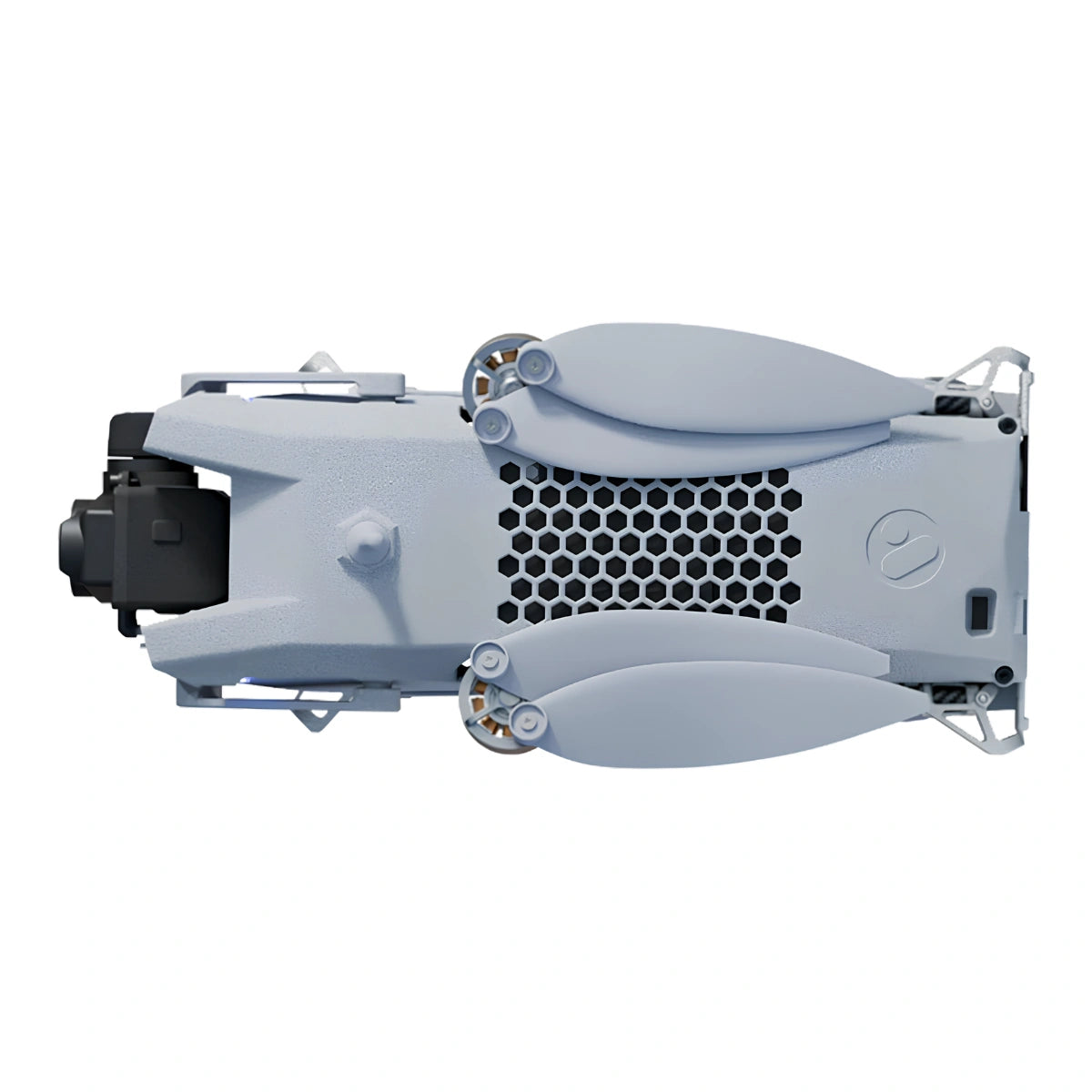
The Vantage Robotics Trace redefines what a sub-200-gram UAV can deliver in a mission-critical environment. Built entirely in the United States and carrying DoD Blue UAS Cleared and NDAA compliant status, Trace integrates a 2-axis stabilized Wisp gimbal combining a 48MP electro-optical camera and 320p infrared sensor into an airframe that weighs 153 grams, folds into a field case smaller than a lunchbox, and launches from an operator's hand in under 30 seconds.

For public safety agencies evaluating nano UAS platforms, Trace closes the gap between what a pocket-sized drone is expected to do and what it actually can.

Key Features and Benefits

  • 48MP EO sensor: autofocus f/1.8 lens resolves fine detail at 25× digital zoom.
  • Thermal imaging: 320×240 uncooled VOx IR sensor with 24° field of view onboard.
  • Flight endurance: up to 30 minutes operational time with included Standard Batteries.
  • Encrypted link: AES-256 with automatic channel hopping across 6 km LOS range.
  • 360° obstacle avoidance: laser range-finding enables indoor and confined-space operation.
  • GPS-denied stability: visual inertial odometry with scene illumination maintains position indoors.
  • Covert operation: unseen and inaudible at 30 feet with optional Remote ID compliance.
  • Hand-launch ready: 153 g airframe deploys from IP67 field case in under 30 seconds.
  • Wind performance: stable and controllable in sustained field winds up to 25 knots.
  • Platform security: AES-256 encryption, secure boot, no remote data transmission architecture.

Trace is purpose-built for the operational realities that public safety teams face: dynamic environments, compressed timelines, limited personnel, and zero tolerance for data compromise. The platform's 6 km line-of-sight range, AES-256 encrypted communications with no remote data connect, and compatibility with ATAK, QGC, WMI, and RAC2 mean it drops into existing agency workflows without requiring infrastructure changes.

With 360° obstacle avoidance, GPS-denied visual position control, and a covert acoustic and visual profile at 30 feet, Trace functions as a deployable ISR node that fits in a cargo pocket.

A Deployable ISR Node That Fits Agency Infrastructure

Trace is not a consumer drone adapted for professional use — it is a ground-up ISR platform engineered to slot into existing public safety and government operational frameworks. MAVLink and RAS-A compliance means Trace communicates fluently with the C2 infrastructure agencies already operate. ATAK compatibility allows real-time video and positional data to feed directly into tactical common operating pictures without additional middleware.

The Vision2 GCS  included in this bundle provides a 7-inch, 2,500 nit sunlight-readable display with a 4-hour battery life, purpose-built controls, and NDAA and TAA compliant manufacturing. Agencies procuring Trace are acquiring a system that is ready to integrate, not one that requires custom adaptation.

Compatibility and System Integration

  • Vision2 GCS: NDAA/TAA compliant controller with 7 in display and 4-hour operational life.
  • Wisp EO/IR gimbal: 2-axis stabilized payload with 320p IR, field-upgradeable to 640×480.
  • ATAK: direct integration for real-time video and positional data in tactical environments.
  • Kutta KTAC and S20 TE: alternative C2 platforms for agencies with existing Kutta infrastructure.
  • Tomahawk Mimic and Grip GCS: additional compatible controllers for flexible operator configurations.
  • QGC, WMI, and RAC2: supported GCS software for mission planning and flight management.
  • MAVLink and RAS-A: open protocol compliance ensures interoperability across mixed-fleet deployments.

Applications and Use Cases

  • Tactical reconnaissance: covert profile supports undetected pre-entry and overwatch operations.
  • Search and rescue: dual EO/IR sensors identify subjects across varied lighting and terrain conditions.
  • Indoor and confined-space ops: 360° avoidance and GPS-denied stability enable structure entry.
  • Incident command integration: live feeds connect to ATAK common operating picture in real time.
  • Perimeter and asset monitoring: perch-and-stare capability reduces battery consumption on static posts.
  • Fleet ISR deployment: lightweight form factor supports multi-unit deployment from a single vehicle.
  • Infrastructure and evidence documentation: 48MP stills and 4K video capture forensic-grade imagery.

Trace answers a persistent procurement challenge for public safety agencies: how to field persistent aerial ISR capability without the cost, crew, and logistics of larger platforms. At 153 grams with a 30-minute operational endurance, 6 km encrypted range, and full ATAK integration, it delivers enterprise-grade capability in a system any officer can carry and any agency can afford to fleet.

Dronefly has spent years building UAV solution partnerships with public safety agencies, and the Vantage Robotics Trace Public Safety Bundle reflects exactly the kind of platform those partnerships are built around.

When you source Trace through Dronefly, you gain access to configuration guidance, fleet deployment support, and the procurement expertise to match the right bundle to your agency's operational requirements. Reach out to Dronefly today to discuss how Trace fits your mission profile.

Aircraft

  • Flight time: 36 minutes
  • Indoor/outdoor operation: Obstacle avoidance, visual position control, and scene illumination for GPS-denied environments
  • Airframe mass: 153 g takeoff weight
  • Flight speed: 52 kph (32 mph) top speed
  • Stealth: <37 dBA at 25 m
  • Visibility: Not visible at 30 ft against terrain
  • Operational wind range: Up to 25 kts
  • Operational temperature range: -20°C to 45°C
  • Ingress protection: IP53
  • Autonomous missions: Multi-constellation GPS
  • Launch: Hand or flat ground
  • Perch and stare capable

Security

  • Origin: Designed, sourced, and built in USA
  • Encryption: AES-256 on communications and data storage
  • Security compliance: DoD Blue (pending) and NDAA compliant
  • Data transmission: No remote data transmission

Control & Communications

  • LOS range: 6 km
  • NLOS range: 500 m (30 dBi attenuation)
  • Frequencies available: 2.4 GHz ISM and multi-band alternatives
  • Channels: Automatic channel hopping
  • Connection standards: MAVLink and RAS-A compliant
  • GCS software compatibility: QGC, ATAK, WMI, RAC2
  • Controller compatibility: Vantage Vision 2, Kutta KTAC, S20 TE, Tomahawk Mimic, Grip GCS

Portability

  • Launch time: Deployable in 30 seconds
  • Compact stowage: Folding arms
  • Durability in field case: IP67 waterproof case with 90 kg crush and 1 m drop resistance
  • Weight: <1000 g and 1000 cm³ with field case, 2 batteries, and Vision2 GCS
  • Transport case: Watertight, dustproof, dent-proof

Gimbal & Camera

  • Gimbal: 2-axis stabilized EO/IR gimbal
  • Gimbal pitch control: -90° to +70° user controllable
  • Sensors: EO and thermal, upgradeable to 640 × 480 thermal
  • EO camera: 48 MP
  • EO optics: f/1.8 lens with autofocus
  • Zoom: 25× digital zoom (67°–2.7° HFOV)
  • Still images: 8000 × 6000 px
  • Thermal sensor: 320×240 IR uncooled VOx sensor 24º or 57º HFOV options
  • Video recording format: 1080p or 4K MPEG-4
  • 1x Trace Aircraft (2.4GHz)
  • 1x Wisp EO/IR Gimbal 320p IR-Color Payload
  • 1x Vision2 GCS
  • 1x 2.4GHz Radio Module
  • 1x GCS Charger with Cable (USB-C)
  • 2x Spare Rotors
  • 2x Trace Standard Batteries
  • 1x Trace Propeller Guards (Pair)
  • 1x Trace Multi-Battery Charger (USB-C)
  • 1x Trace Field Case
  • 1x Transport Case
What does the Vantage Robotics Trace Public Safety Bundle include?

The bundle includes the Trace aircraft (2.4GHz), Wisp EO/IR gimbal with 320p IR payload, Vision2 GCS, 2.4GHz radio module, two Standard Batteries, a multi-battery USB-C charger, GCS charger with USB-C cable, propeller guards, two spare rotors, an IP67 field case, and a transport case. The complete system is ready to deploy out of the box with no additional hardware required. Agencies can begin operations immediately upon receiving the bundle.

How does the Trace perform in GPS-denied and indoor environments?

Trace maintains full position control in GPS-denied environments through a downward-facing visual inertial odometry system combined with an integrated scene illuminator for low-light conditions. The 360° obstacle avoidance system uses laser range-finding sensors to enable safe navigation through structures, corridors, and confined spaces. Daytime GPS-denied operation is supported up to 30 meters altitude; nighttime operation with illumination is supported up to 3 meters.

How does the Trace integrate with ATAK and existing agency C2 infrastructure?

Trace is MAVLink and RAS-A compliant and directly compatible with ATAK, QGC, WMI, and RAC2 ground control software. The included Vision2 GCS supports multiple GCS applications and can run custom APKs, allowing agencies to configure the system around existing workflows rather than replacing them. For agencies already operating ATAK in the field, Trace feeds live video and positional data directly into the common operating picture.

What are the procurement compliance credentials for the Trace?

Trace carries DoD Blue UAS Cleared status and is fully NDAA compliant, meeting federal and state procurement standards for government and law enforcement agencies. All communications and stored data are protected by AES-256 encryption with secure boot architecture and no remote data transmission. The platform is designed, sourced, and built entirely in the United States.

Can Dronefly support fleet procurement or multi-unit deployments of the Trace?

Yes. Dronefly specializes in UAV solutions partnerships for public safety and government agencies, including multi-unit fleet procurement, deployment configuration, and ongoing lifecycle support. Agencies evaluating Trace for department-wide or multi-unit deployment are encouraged to contact Dronefly directly to discuss volume configurations, bundle customization, and integration support tailored to their operational requirements.

How does the 640p thermal sensor expand operational capability for public safety agencies?

The Wisp w/640p IR gimbal delivers 640×480 thermal resolution across a 48° field of view, providing four times the pixel density of the standard 320p configuration and a significantly wider thermal scene.

For public safety operations, this translates to more reliable subject identification in darkness, smoke, and obscured terrain — and a wider thermal picture that reduces the need for repositioning during active searches. Agencies prioritizing thermal performance for nighttime or low-visibility operations will find the 640p configuration the appropriate baseline.