
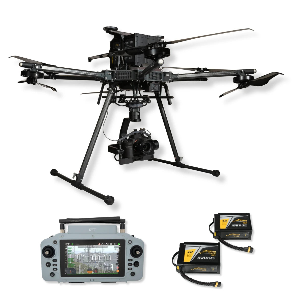
Inspired Flight IF1200 with GS-ONE + Sony ILX-LR1 Bundle
Inspired Flight IF1200 with GS-ONE + Sony ILX-LR1 Bundle

Couldn't load pickup availability
- Description
- Specifications
- In the Box
- FAQ
IF1200A + GS-ONE & Sony ILX-LR1 Bundle: Integrated Enterprise Imaging Platform
The IF1200A with GS-ONE and Sony ILX-LR1 is a turnkey aerial imaging system designed for industrial mapping, surveying, and inspection.
The package includes the IF1200A heavy-lift hexacopter, GS-ONE rugged ground control station, IF1200 battery set, the required Dovetail Kit 3.0, and the Sony ILX-LR1 full-frame imaging payload.
Built for professional operators, it offers long flight endurance, secure payload integration, and high-resolution aerial imaging capabilities in a single ready-to-deploy solution.
Key Features and Benefits
- 43-minute max flight time: supports extended survey missions
- 19.1-lb payload capacity: accommodates multiple sensor options
- NDAA compliant, Blue UAS approved: authorized for enterprise use
- GS-ONE controller: rugged IP55, bright 7-inch touchscreen
- Hot-swappable power: keep missions running continuously
- Triple redundant safety sensors: reliable performance every flight
- Sony ILX-LR1: 61MP aerial imaging with low noise
- Remote image controls: exposure and shutter adjustments in flight
- Dovetail Kit 3.0: modular payload mounting system
- Full battery set: field-ready operational kit
Dependable Operations with Advanced Ground Control
The IF1200A platform provides up to 43 minutes of endurance and supports payloads of up to 19.1 pounds. Designed with NDAA compliance and Blue UAS approval, it meets government and enterprise requirements for secure operations.
The GS-ONE ground station adds reliability with its rugged IP55 build, daylight-readable 7-inch display, and hot-swappable battery. Together, the system ensures seamless control, safety, and mission flexibility in field conditions where uptime matters most.
High-Precision Imaging with Seamless Integration
The Sony ILX-LR1 delivers 61-megapixel full-frame resolution engineered for drone operations. Mounted via the IF1200 Dovetail Kit 3.0, it ensures secure attachment and proper balance for safe flights.
Operators can adjust camera parameters in real time via Sony's remote SDK, capturing precise data for mapping, inspection, and survey tasks.
Lightweight yet powerful, the ILX-LR1 complements the IF1200A's endurance and payload support, delivering enterprise-level imaging without compromising flight performance.
Applications and Use Cases
- Aerial photogrammetry: generate accurate 3D terrain and maps
- Utility inspections: monitor pipelines, power lines, and towers
- Infrastructure assessment: survey bridges, railways, and highways
- Public safety and response: rapid imaging in disaster scenarios
- Construction monitoring: recurring 3D models for site management
- Agriculture and forestry: crop health and canopy assessments
- Environmental projects: coastline and erosion documentation
- Forensics and law enforcement: secure aerial evidence gathering
- Urban development: geospatial datasets for city planning
- Industrial asset surveys: evaluate large facilities and equipment
This bundle combines endurance, payload flexibility, and imaging power in one system built for enterprise workflows. With Dronefly support, integration, and service options, professionals can deploy with confidence and efficiency.
Dronefly is a trusted West Coast dealer for Inspired Flight and Sony payloads. Shop the IF1200 + ILX-LR1 bundle today and get expert assistance for integration and ongoing support.

