


MicaSense RedEdge-P
MicaSense RedEdge-P

Couldn't load pickup availability


- Description
- Specifications
- In the Box
- FAQ
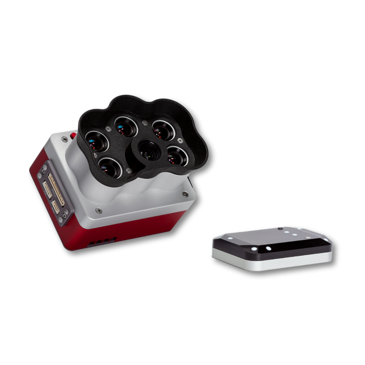
MicaSense RedEdge-P Multispectral Kit: scalable five-band multispectral analytics for enterprise surveys
The MicaSense RedEdge-P Multispectral Kit supports enterprise teams performing precision agriculture and environmental monitoring at scale. As a standalone multispectral sensor, it captures five narrow spectral bands using global shutter imaging to reduce motion distortion during survey flights. The system supports consistent time-series analysis under changing illumination and produces datasets commonly used for vegetation indices and analytical mapping workflows.
Designed within the modular RedEdge-P camera ecosystem, the RedEdge-P can operate independently or scale into expanded spectral configurations when paired with compatible RedEdge-P family cameras.
Five-band multispectral system overview
- Five multispectral bands support vegetation reflectance and index workflows
- Global shutter imaging reduces motion distortion during aerial surveys
- Panchromatic band supports pan-sharpening with post-processing workflows
- RGB output aligned with multispectral bands supports mapping deliverables
- Raw DNG capture preserves analytical data integrity
- Capture rates up to three frames per second improve coverage efficiency
- CFexpress storage supports high-speed data recording
- Expandable architecture supports dual or triple camera configurations
Image quality and spatial resolution
The RedEdge-P Multispectral Kit captures 1456 × 1088 pixels per multispectral band with a 2464 × 2056 panchromatic band and a 5.1 MP RGB output aligned to all bands. At 120 m (approximately 400 ft) AGL, published references include 7.7 cm (3 in) multispectral ground sample distance and 3.98 cm (1.5 in) panchromatic ground sample distance. With appropriate post-processing, pan-sharpening can achieve spatial detail of up to 2 cm (0.8 in) per pixel for detailed analytical mapping.
Spectral outputs and expandable analytics
The RedEdge-P band set supports outputs referenced as RGB, NDVI, NDRE, OSAVI, CIR, and DSM for vegetation monitoring and mapping workflows. This enables consistent comparisons across seasons and management practices. For expanded analytics, the camera family supports dual configurations using two RedEdge-P family cameras for up to ten selectable spectral bands. When combined with RedEdge-P Blue and RedEdge-P Green cameras, a triple configuration supports synchronized capture of fifteen multispectral bands.
Platform compatibility and workflow integration
- Compatible with professional UAV platforms, including DJI enterprise aircraft
- Supports standalone operation as a single multispectral payload
- Integrates into dual configurations with RedEdge-P family cameras
- Supports triple configurations with RedEdge-P Blue and RedEdge-P Green
- Enables synchronized capture using shared timing signals
- Supports Ethernet, serial, and GPIO interfaces for integration
- Compatible with common multispectral processing workflows
Professional applications and field use cases
- Precision agriculture monitoring: evaluate crop vigor, stress, and treatment effectiveness
- Vegetation index mapping: generate NDVI, NDRE, OSAVI, and CIR datasets
- Weed identification workflows: differentiate crops, weeds, and invasive species accurately
- Crop counting analysis: support early growth assessment using machine learning techniques
- Environmental monitoring missions: track vegetation change and ecosystem health over time
- Forestry assessment operations: analyze canopy condition and vegetation distribution patterns
- Conservation and restoration projects: monitor habitat recovery and biodiversity indicators
- Research field programs: perform repeatable time-series multispectral data collection
Radiometric tools supporting consistent data quality
An integrated Downwelling Light Sensor 2 measures ambient lighting conditions during each flight, while the included calibration reflectance panel supports reflectance correction workflows. These tools help ensure that collected data can be compared across flights, dates, and environments, supporting long-term monitoring and research programs.
Compare: Altum-PT vs RedEdge-P
| Category | Altum-PT | RedEdge-P |
|---|---|---|
| Core focus | Multispectral + thermal + RGB in a single payload | High-resolution multispectral + RGB capture |
| Thermal capability | Radiometric FLIR LWIR, 320 × 256 | Not available (no thermal sensor) |
| Multispectral bands | 5 bands: Blue, Green, Red, Red Edge, NIR | 5 bands per sensor; up to 10 bands with a dual-camera configuration |
| RGB / panchromatic | 12 MP panchromatic sensor | 5.1 MP panchromatic output (pan-sharpened) |
| Multispectral GSD @120 m | 5.28 cm/pixel | 7.7 cm/pixel |
| Pan-sharpened spatial detail | 2.49 cm/pixel @120 m (≈1.25 cm/pixel @60 m) | ≈3.98 cm/pixel @120 m (≈2 cm with pan-sharpening) |
| Thermal GSD @120 m | 33.5 cm/pixel | N/A |
| Capture rate | Up to 2 images per second (all bands, RAW) | Up to 3 images per second (RAW) |
| Media / storage | CFexpress card | CFexpress card |
| Radiometric calibration | Integrated multispectral + thermal calibration | Multispectral calibration with dual calibration panels |
| Typical system weight | ≈577 g | ≈745 g (dual-sensor configuration) |
| Where it fits best | Irrigation diagnostics, water stress, soil moisture, thermal crop analysis | Vegetation indices, crop vigor, classification, time-series analysis |
Engineered for analytical reliability
The RedEdge-P Multispectral Kit is designed for enterprise operations requiring consistent data and predictable system integration. Published specifications reference IP4X protection, wide external power input, and defined operating temperature ranges with adequate airflow. Double radiometric calibration using a downwelling light sensor and calibration reflectance panel is referenced to improve reliability under changing illumination. Standardized interfaces and raw DNG capture support interoperable enterprise mapping workflows.
The MicaSense RedEdge-P Multispectral Kit delivers dependable five-band multispectral analytics with scalable expansion options for enterprise field programs.
Order from Dronefly today — the West Coast’s trusted enterprise UAV source.

