The Best Thermal Drones and Thermal Cameras of 2025
A Buyer’s Guide for Public Safety, Inspection, and More
Why Thermal Drones Are in High Demand in 2025
Thermal drones have shifted from specialized gear to operational must-haves. In 2025, they’re built into the core workflows of public safety agencies, utility teams, precision farmers, and environmental operators who can’t afford to miss critical heat signatures.
What’s driving adoption? The tech finally caught up. Today’s systems offer higher thermal resolution, onboard AI, automated mapping, and real-time data capture—all in lighter, longer-flying aircraft that launch fast and work harder.
Whether you're flying low through smoke to spot flare-ups, scanning panels for thermal anomalies, or locating a missing hiker in near-zero visibility—thermal drones are doing work that used to take hours, teams, or pure luck.
And that’s why they’re showing up everywhere—from wildfire zones to wind farms, crop fields to crime scenes. If your operation still relies on visual-only data, you're already behind.
What’s New Since Our 2022 Guide
In 2022, we reviewed some of the earliest standout thermal drones on the market. Back then, models like the DJI M300 RTK + H20T and Mavic 2 Enterprise Dual were the go-to options. They were good—but 2025 models now deliver:
- Sharper thermal detail (1280×1024 resolution is becoming the norm)
- AI-assisted mapping and automated detection
- Longer flight times with swappable batteries
- Seamless integration with GIS, FLIR tools, and live mission software
If you read the 2022 version of this article, this update shows how far thermal drone tech has come in just a few years—and which new tools actually deserve your investment.
How Thermal Drone Cameras Work

What You’re Really Seeing Isn’t Light—It’s Heat
Thermal drones don’t capture light—they detect temperature differences. Everything with a temperature emits infrared radiation. Thermal cameras onboard the drone convert this into an image you can analyze in real time.
It sounds complex, but here’s what matters most for choosing the right payload:
Are you reading actual temperatures (radiometric)? How sharp is the resolution? Can you trust the image at speed?
Let’s break it down.
Infrared Imaging 101
Thermal cameras measure longwave infrared radiation (typically 8–14μm wavelength). This data is then mapped into visible color gradients—like orange for heat, blue for cold.
There are two main types:
1. Radiometric Thermal Cameras
- Capture accurate surface temperatures for each pixel
- Ideal for inspection, compliance, technical reports
- Cost more but critical for professional use
2. Non-Radiometric Cameras
- Visualize relative heat levels, not exact temperatures
- Good enough for general detection (SAR, security)
- Often lighter, cheaper, and faster to deploy
Quick Tip:
If your drone mission involves data logging, reporting, or regulatory inspections—radiometric is non-negotiable.
Resolution: More Pixels, More Precision
Thermal resolution determines how sharp and detailed your images are. In 2025, these are the key resolution standards:
| Resolution | Common Use Cases |
|---|---|
| 320×256 | Entry-level SAR, first responders, basic inspection |
| 640×512 | Industry standard; great for public safety and inspection |
| 1280×1024 | High-end; ultra-detailed mapping and large-scale site scanning |
More pixels mean you can spot finer differences in temperature. That matters when inspecting a solar farm with thousands of panels—or looking for a person lost in the woods.
Frame Rates, Color Palettes, and Image Modes
- Frame Rate: A higher frame rate (30–60 Hz) gives you smoother imaging—critical when flying fast or scanning moving subjects.
- Color Palettes: Common ones include White Hot, Black Hot, Ironbow, and Rainbow. Each emphasizes heat contrasts differently.
- Image Blending: Many drones overlay thermal over RGB for context. DJI’s Isotherm and MSX (FLIR) give better situational awareness.
Thermal Fact Check:
High resolution doesn’t always mean better results.
It depends on your altitude, frame rate, lens quality, and flight speed. A poorly tuned 1280×1024 camera may perform worse than a well-set 640×512 on the right platform.
Know What You’re Buying
You’re not just buying a camera—you’re buying a sensor system. Specs like resolution and radiometry only matter if they match your mission. And not all payloads deliver what they claim on paper.
Drone Sensor Technologies Explained
Not All Sensors See the Same World—Here’s How to Choose Wisely
Thermal imaging is powerful, but it’s just one piece of the puzzle. Depending on your mission, you may need other types of sensors—or combinations of them. In 2025, many drones come with swappable or integrated payloads, making it easier (and more confusing) to mix and match.
This section breaks down the most common drone sensors, how they work, and what they’re actually useful for.
Thermal Sensors
Detect heat. Great for visibility when visual light fails.
- Best For: Search and rescue, firefighting, industrial inspection, wildlife tracking
- Strengths: See through smoke, spot hidden subjects, operate at night
- Limitations: No texture or color detail, affected by glass/water surfaces
Thermal cameras show you where the heat is. But if you need 3D structure or surface texture—you’ll need backup.
LiDAR Sensors
Use laser pulses to build detailed 3D models.
- Best For: Topography, structural mapping, vegetation canopy models, corridor mapping
- Strengths: Precision down to centimeters, even in low light
- Limitations: Can’t detect heat, heavier, pricier, requires post-processing
LiDAR is for when you need geometry, not imagery. Think terrain mapping or infrastructure measurement.
RGB Sensors
The standard visible light camera.
- Best For: Photography, general documentation, object ID, visual inspection
- Strengths: True-color images, easy to interpret, usually high-resolution
- Limitations: Useless in smoke, darkness, or fog
RGB gives the human-friendly view. It’s what most people think of when they picture a “camera.”
Multispectral Sensors
Capture narrow light bands outside the visible range.
- Best For: Agriculture, environmental monitoring, water stress analysis
- Strengths: Detects crop health issues before they’re visible
- Limitations: Niche applications, requires special software to interpret
These sensors look beyond color. If your job involves plants, multispectral might be a must.
Hyperspectral Sensors
Capture hundreds of spectral bands.
- Best For: Mining, oil and gas, research, chemical identification
- Strengths: Unmatched material identification and spectral data
- Limitations: Expensive, complex, rarely used outside of research or specialized industry
Common Drone Sensor Pairings by Industry:
| Industry | Typical Sensor Combo |
|---|---|
| Firefighting/SAR | Thermal + RGB |
| Utilities/Inspection | Thermal + RGB or Thermal + LiDAR |
| Agriculture | Multispectral + RGB |
| Construction/Surveying | LiDAR + RGB |
| Environmental | Thermal + Multispectral |
Don’t fall for “do-it-all” payload promises. Many missions still need multi-sensor setups.
Sensor Comparison Table
Match Sensor to Mission
Buying the wrong sensor means wasted budget, missed data, or both. Know what you need to measure—heat, light, structure, or vegetation—before picking a payload. The right sensor (or combo) makes the difference between a great mission and a guessing game.
Coming up next: the real-world factors that should guide your thermal drone purchase—and how to avoid common buying mistakes.
Factors to Consider When Choosing a Thermal Drone

Not All Thermal Drones Are Built for Your Mission
Buying a thermal drone isn’t just about picking the one with the best camera specs. It’s about choosing the right platform for your specific operational needs. And getting it wrong? That usually means overpaying—or underperforming.
This section walks you through what really matters before you hit “Buy.”
1. Mission Type Comes First
Different jobs need different features. Start here:
- Search and Rescue: Fast deployment, zoom+thermal, long flight time
- Firefighting: Radiometric sensors, thermal+RGB overlays, flight stability in smoke
- Inspection: Radiometric accuracy, high-res thermal, mapping integration
- Wildlife Monitoring: Quiet flight, long range, night-vision combo
If you can’t define your mission, you can’t define your gear.
2. Radiometric vs. Non-Radiometric Payloads
This is your most important sensor choice.
- Go radiometric if: You’re inspecting infrastructure, need reports, or measuring heat precisely.
- Go non-radiometric if: You’re scanning for general heat presence—like during SAR or wildlife detection.
3. Payload Compatibility and Modularity
- Can you swap out sensors?
- Can you upgrade later?
- Will your drone work with third-party software like FLIR Tools or Pix4D?
Some drones lock you into one payload. Others, like the Matrice 350 RTK, are built for customization.
4. Flight Time and Operational Range
- Multi-rotor drones: Easier to deploy, stable hover, 30–50 min typical flight time.
- Fixed-wing drones: Long range (up to 90 mins), better for covering wide areas fast.
SAR in dense forests? Go multi-rotor. Surveying 10,000 acres? Fixed-wing wins.
5. Durability and Weather Resistance
You’ll be flying in the real world—not a spec sheet.
- Wind resistance: Anything below 20 mph rated is risky for industrial work
- Rain resistance: Look for IP-rated models (e.g., IP45 on the Matrice 30T)
- Operating temps: Cold weather flights require heated batteries and protected gimbals
6. Budget vs. ROI
A $10,000 drone isn’t “expensive” if it prevents a $100,000 mistake.
Common pricing tiers:
- Entry-level: $4,000–$7,000
- Mid-range: $8,000–$12,000
- High-end: $13,000 and up
7. Software Integration
Don’t overlook this. The best drones pair tightly with their own or third-party apps.
- DJI Pilot 2: Powerful mission planning and live streaming
- Autel Explorer: App-based smart features and camera settings
- Pix4D / DroneDeploy: Cloud-based mapping and thermal post-processing
- FLIR Tools: Essential for analyzing radiometric data
Dronefly Recommends:
Top Decision Factors (in order of priority):
-
- Mission Type
- Radiometric Need
- Payload Compatibility
- Flight Time
- Weather Resistance
- Budget
- Software Ecosystem
If a drone can’t complete your mission reliably—it’s not the right drone. Specs won’t save you in the field.
Skip the Spec Sheet, Think Mission First
Thermal drones aren’t one-size-fits-all. The smartest teams focus on mission success first, then find the model that fits—not the other way around. Want help sorting it out? Our Dronefly experts can walk you through every option.
Next up: we review the best thermal drones of 2025—and show you what each one is really good at.
Top Thermal Drones of 2025 – Detailed Reviews
The Best Thermal Platforms Worth Buying This Year
Drone makers are finally delivering the thermal drones we actually need: modular, smart, reliable, and compliant. But not all “top drones” are built for real-world operations.
We’ve reviewed and field-tested this 2025 list for performance, payload quality, integration, and mission readiness.
DJI Matrice 350 RTK + Zenmuse H20T / H20N / H30T
Top-Tier Powerhouse for Enterprise and Public Safety
The Matrice 350 RTK is DJI’s flagship industrial drone—and in 2025, it’s still the most adaptable workhorse in the thermal space. With support for H20T, H20N, and the new H30T payload, this system is built for serious operations.
Key Specs
-
Max Flight Time: ~55 mins (without payload)
IP Rating: IP55 (dust and water resistance) - Max Transmission Range: 20 km (O3 Enterprise)
- Payloads:
- H20T: 640×512 thermal, 20MP zoom, laser rangefinder
- H20N: Better low-light visual + thermal combo
- H30T: 1280×1024 thermal resolution, 34x optical zoom, 1200m rangefinder
Strengths
- Radiometric thermal data with pin-point accuracy
- Modular payloads—swap thermal, LiDAR, zoom, or wide-angle
- Long flight time and ultra-stable hover
- RTK positioning for centimeter-level mapping
- Rugged build for high-wind, wet-weather operations
- Night-time surveillance with starlight sensors (H20N/H30T)
Limitations
- Price: Full system can easily reach $25K+
- Training required for full payload use
- May be overkill for smaller agencies or rural deployments
Real-World Use Case
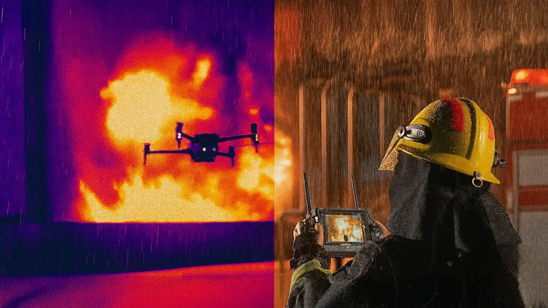
🚒 Fire Department Use:
A California fire agency used the Matrice 350 RTK + H30T to track hot spots and structural heat layers through heavy smoke during a warehouse fire. The onboard starlight camera allowed clear situational awareness even at 2:00 AM, while the thermal sensor helped pinpoint unseen flare-ups inside collapsed roofs.
Dronefly Recommends:
Best Use Cases for the M350 RTK:
-
- Wildland and urban firefighting
- Utility and oil field inspections
- Search and rescue with zoom + thermal combo
- Law enforcement surveillance
- Industrial mapping and thermal audits
This is the drone you bring to the most complex missions. It’s big, fast, and sees in the dark—clearly.
DJI Matrice 30T
Compact. Tough. Built for Tactical Response.
The Matrice 30T is DJI’s rapid deployment drone with an integrated thermal and visual camera—no payload swaps required. It folds into a small case but delivers serious thermal imaging power.
Key Specs
- Max Flight Time: ~41 mins
- Thermal Resolution: 640×512
- IP Rating: IP55
- Integrated Camera: 48MP zoom, wide, thermal, and laser rangefinder
Strengths
- Compact and quick to deploy
- Excellent weather resistance
- Fully integrated payload—no gimbal balancing needed
- Laser rangefinder for targeting up to 1,200m
- Works with DJI Dock for autonomous ops
Limitations
- Fixed payload—no upgrade path
- Less zoom range than the M350 + H30T combo
- Slightly shorter flight time
Real-World Use Case
🚓 Police SAR Deployment:
During a mountain search operation in Washington state, the Matrice 30T located a missing hiker by detecting a heat signature under tree cover—then hovered while streaming thermal and zoom footage to responders on the ground.
Good to Know:
M30T vs M350 RTK:
-
- M30T: Faster to deploy, lighter, fixed payload
- M350 RTK: More flight time, swappable payloads, higher cost
Choose the M30T when speed and mobility matter more than future upgrades.
DJI Mavic 3T Enterprise
Entry-Level Price. Pro-Level Radiometric Output.
Small, light, and under $6,000—the Mavic 3T makes thermal drones more accessible to small agencies and contractors without compromising on key features.
Key Specs
- Max Flight Time: ~45 mins
- Thermal Resolution: 640×512 (radiometric)
- Visual Camera: 48MP wide, 56x hybrid zoom
- Transmission Range: 15 km
- Weight: 920g
Strengths
- Surprisingly long flight time for size
- Lightweight and easy to travel with
- Radiometric thermal at entry-level price
- Ideal for single-operator teams
- Works with DJI RC Pro Enterprise controller
Limitations
- No obstacle avoidance
- Fixed payload
- Limited integration with advanced software
Real-World Use Case
🌾 Ag Co-op Drone Program:
A Midwest farming group used the Mavic 3T to detect irrigation leaks and monitor livestock pens during winter. The drone delivered reliable radiometric maps and clear thermal snapshots without a massive training curve.
✅ Content Block: Dronefly Suggests
Best Fit For:
- First-time public safety drone units
- Entry-level thermal inspections
- Light-duty agricultural scouting
- Budget-restricted departments
This is the “gateway drone” to professional thermal imaging—and it pulls its weight.
Autel EVO Max 4T
Smart, Agile, and Built for Night Ops
The EVO Max 4T is Autel’s most advanced thermal platform yet—and a serious contender for agencies that want enterprise-level power without the DJI ecosystem. It’s compact, intelligent, and fully loaded with obstacle avoidance, making it ideal for tactical and confined missions.
Key Specs
- Max Flight Time: ~42 mins
- Thermal Resolution: 640×512 (radiometric)
- Visual Cameras: 50MP wide, 8K video, 16x digital zoom
- Laser Rangefinder: Up to 1,200m
- Obstacle Avoidance: Full 720-degree coverage
- Transmission Range: 12.4 miles (20 km)
Strengths
- Strong thermal and visual combo for price
- Advanced obstacle detection from all angles
- Modular gimbal with radiometric output
- Supports encrypted transmission
- Uses Autel Explorer app (flexible and growing platform)
Limitations
- App interface less mature than DJI Pilot 2
- Smaller third-party software support
- Slightly bulkier than the DJI M30T
Real-World Use Case
🔍 Urban Tactical Response:
A midwestern SWAT team used the EVO Max 4T for nighttime surveillance of a multi-story building. With 3D flight path planning and radiometric imaging, the team coordinated positioning while avoiding obstacles like light poles and trees.
Dronefly Suggests:
Best Fit For:
-
- Law enforcement tactical units
- Mid-budget inspection teams
- DJI-alternative agencies
- Anyone needing all-direction obstacle detection
If you want full control and great thermal performance without going all-in on DJI, this is it.
Teledyne FLIR SIRAS
NDAA-Compliant. FLIR Inside. Built for U.S. Agencies.
The SIRAS is Teledyne FLIR’s answer to security-focused drone buyers who need solid imaging without overseas tech. It’s one of the few drones with true U.S. compliance and the Boson+ thermal sensor built-in.
Key Specs
- Max Flight Time: ~31 mins
- Thermal Resolution: 640×512 (radiometric, FLIR Boson+)
- Visual Camera: 16MP, 1280×720 video
- Transmission Range: ~9 miles
- Modular Payload Bay
- No Geofencing
- NDAA-Compliant
Strengths
- FLIR Boson+ sensor is sharp and reliable
- No restrictions from geofencing software
- Payload is removable and upgradeable
- Fully compliant with U.S. federal purchasing rules
- Designed for public safety and industrial inspection
Limitations
- Shorter flight time than other enterprise models
- Basic visual camera (limited zoom and clarity)
- Less sleek user interface and app support
Real-World Use Case
Critical Infrastructure Inspection: A U.S.-based utility firm chose the SIRAS over Chinese platforms for inspecting substations and transmission towers, citing FLIR reliability and NDAA compliance as key procurement factors.
Dronefly Recommends
Ideal For:
-
- Government contractors
- Utility providers under NDAA requirements
- Departments needing geofence-free flying
- Organizations prioritizing U.S.-made tech
If NDAA compliance is a line in the sand, this is your safest bet—built to spec, no compromises.
Parrot Anafi USA with Thermal
Budget-Friendly and Lightweight—Good Enough for Basics
The Parrot Anafi USA Thermal doesn’t compete with heavy-hitters like the M350 or EVO Max—but for departments with tight budgets, it offers a reliable thermal tool under $7,000. Made in the U.S. and NDAA-compliant, it works well for general patrols and light inspection.
Key Specs
- Max Flight Time: ~32 mins
- Thermal Resolution: 320×256 (non-radiometric)
- Visual Camera: 32x zoom, 4K video
- Weight: 500g
- IP Rating: IP53
- Encrypted SD storage
Strengths
- Lightweight and portable
- Easy to fly with minimal training
- Works well for fast thermal snapshots
- Affordable and NDAA-compliant
- Ideal for basic SAR, perimeter sweeps, and patrol
Limitations
- Lower thermal resolution
- No radiometric capabilities
- Limited flight autonomy and camera range
Real-World Use Case: Rural Law Enforcement:
A sheriff’s department in Texas used the Anafi USA Thermal to monitor ranch borders and assist in missing person searches. Its small size made it ideal for solo officers and quick deployments.
Good Enough If...
Use this drone if:
-
- You need quick access to thermal imagery
- You’re working with limited budgets
- You don’t need radiometric data or detailed zoom
It’s not flashy, but it gets the job done for patrol-level ops and basic monitoring.
Optional: Fixed-Wing and Specialty Systems
Long Range, Big Area, One-Purpose Flights
If your goal is to scan thousands of acres—not hover over a target—fixed-wing thermal drones may be the better fit.
One standout: senseFly eBee X with Duet T thermal payload
Key Specs
- Flight Time: Up to 90 mins
- Coverage: 500–1,200 acres per flight
- Thermal Sensor: FLIR-based Duet T (320×256)
- Use Case: Precision agriculture, pipeline inspection, conservation
Why It Works
- Efficient area coverage
- Lightweight and silent
-
Good for thermal mapping over wide terrain
Less useful for target tracking or hover missions
Choose fixed-wing thermal drones when endurance, range, and area matter more than camera flexibility.
Recommended Thermal Camera Payloads
The Brains Behind the Drone: Thermal Imaging at the Sensor Level
Thermal drones are only as good as the sensors they carry. Some come with cameras built in (like the Mavic 3T or Matrice 30T), but others—like the Matrice 350 RTK or Teledyne FLIR SIRAS—let you swap payloads depending on the mission.
Here’s a look at the best thermal payloads available in 2025, from DJI, FLIR, and Autel.
FLIR Vue TZ20-R
Long-Range Thermal with Dual Zoom Lenses
One of the most powerful FLIR payloads on the market, the Vue TZ20-R is purpose-built for radiometric inspections. It has dual Boson® thermal imagers and 20x zoom, allowing detection at a distance.
Key Specs
- Thermal Resolution: Dual 640×512
- Radiometric: Yes
- Zoom: 20x digital thermal zoom
- Frame Rate: 30 Hz
- Weight: ~640g
- Mount: DJI SkyPort v2
- Compatibility: DJI M300 / M350 RTK
Use Cases
- Utility and infrastructure inspection
- Border patrol and large-area monitoring
- Solar farm audits
If you need to zoom in on a fault from 500+ feet away, this is your payload.
DJI Zenmuse Series (H20T, H20N, H30T)
Modular, Multi-Sensor Payloads for M300 / M350 RTK
These payloads combine zoom, thermal, and laser rangefinding into one camera head. Each generation brings major upgrades in resolution, low-light clarity, and detection range.
Comparison Table:
| Model | Thermal Res. | Optical Zoom | Notable Feature |
|---|---|---|---|
| H20T | 640×512 | 23x optical | Radiometric + laser rangefinder |
| H20N | 640×512 | 20x optical | Night vision + thermal fusion |
| H30T | 1280×1024 | 34x optical | High-res thermal + starlight camera |
The H30T is the top-tier choice in 2025. It’s the most versatile sensor package DJI has ever built.
Autel Thermal Modules (EVO Max 4T)
Integrated but Modular
Autel’s EVO Max 4T thermal module is integrated, not swappable—but worth noting for performance. It includes:
- Thermal: 640×512 radiometric
- Visual: 50MP wide, 8K video
- Laser Rangefinder: 1,200m
- Sensor Fusion: Thermal + RGB overlay
While you can’t detach it, this payload delivers a lot of power in a compact system.
FLIR Duo Pro R
Versatile Third-Party Thermal for Integrators
The Duo Pro R is FLIR’s go-to payload for integrators using custom-built drones or non-DJI platforms. It features dual sensors (RGB + thermal) and supports onboard logging and radiometric output.
Key Specs
- Thermal Resolution: 640×512
- Radiometric: Yes
- Visual Sensor: 4K RGB
- Weight: ~325g
- Interfaces: PWM, MAVLink, Bluetooth
- Mounting: Universal
If you're building your own system or using Pixhawk, this is the flexible, pro-grade camera to beat.
Quick Comparison – Which Thermal Payload to Pick?
| Payload | Best For | Key Advantage | Price Range |
|---|---|---|---|
| H30T | Firefighting, inspection | 1280×1024 thermal + 34× zoom | $13,000+ |
| Vue TZ20-R | Infrastructure, long-range | Dual Boson zoom, radiometric | $10,000+ |
| H20T | SAR, mixed ops | Radiometric + laser targeting | ~$9,500 |
| Duo Pro R | Integrators, custom builds | Universal mount, dual sensors | ~$6,000–$7,500 |
| Autel 4T module | Tactical & law enforcement | Full integration, no extra setup | Included w/ drone |
Your drone might be flashy, but the payload is what does the real work. Buy smart.
Accessories and Software Considerations
The Tools Behind the Mission—And the Data That Makes It Count
Thermal drones are only part of the story. What happens after launch—how you control, capture, and analyze that data—matters just as much. From rugged controllers to flight planning tools, the right accessories and software keep operations smooth, safe, and actionable.
Ruggedized Controllers
No one wants to fly a $20K drone using a touchscreen in the rain. Rugged, enterprise-grade controllers make a real difference in field ops.
- DJI RC Plus: Sun-readable screen, hot-swappable batteries, customizable buttons
- Autel Smart Controller V3: Large 7.9" screen, IP43 weather rating, HDMI out
- FLIR SIRAS Ground Station: Purpose-built for glove use and night visibility
If you’re flying in mud, smoke, or snow—bring the right hardware.
Anti-Collision Lighting for Night Flights
Thermal drones often fly in low-light or no-light conditions. That means visibility for nearby personnel and aircraft becomes critical.
- Strobe Beacons: FAA-required for night flights (over 3 miles visibility)
- Mountable LEDs: Attach to arms or landing gear for visual orientation
- Dual-color lights: Green/white or red/blue for direction reference
Night ops without lights? That’s how people lose drones—and trust.
Mission Planning and Mapping Software
Whether it’s thermal inspection or SAR, intelligent flight planning cuts time and reduces human error.
DJI Pilot 2
- Used with M30T, M350 RTK
- Live thermal overlays, isotherm settings
- Pre-mission planning and waypoint repeat
Autel Explorer
- App-based control for EVO Max 4T
- Real-time thermal display, ROI targeting
- 3D mission previews
Pix4D & DroneDeploy
- Post-processing for thermal maps
- NDVI overlays (agriculture), temperature models (inspection)
- Works with radiometric data for compliance reports
Data Integration with GIS Systems
Thermal maps and imagery are most useful when they’re part of something bigger. Integration with geographic information systems (GIS) helps agencies connect aerial data with ground realities.
- ArcGIS: Industry standard for utilities, public safety, and infrastructure
- QGIS: Free and open-source GIS platform with strong drone plug-ins
- FLIR Tools & FLIR Thermal Studio: For analyzing and exporting radiometric datasets
Collecting thermal imagery is easy. Making it actionable takes the right software.
Dronefly Pro Tip:
Don't Skip These Add-ons:
-
- Extra batteries (thermal drones eat power fast)
- Fire-rated hard cases with cut foam
- MicroSD cards rated for high-write speeds (U3 or V30)
- Hand warmers for winter battery care
Skimp on accessories, and you’ll regret it halfway through your first mission.
Regulatory Compliance Notes
Some accessories aren’t optional—especially if you’re flying under FAA rules:
- Part 107: You must have it for any commercial use
- Night Flights: Require FAA waivers and anti-collision lighting
-
Public Agency COAs: Needed for police/fire departments
Insurance: Many policies require data logs and thermal reports for coverage
Don’t Just Buy the Drone—Support It
Thermal drone performance isn’t just about sensors and specs. Mission success depends on how well your drone is supported—by gear, by software, and by the people using it. Underinvest in these areas, and you’re leaving capability (and safety) on the table.
Training and Regulatory Considerations
Flying Is Easy—Doing It Legally and Competently Is the Real Challenge
Buying a thermal drone isn’t hard. Flying one responsibly and legally? That’s where a lot of teams stumble.
Thermal drones, especially when used for public safety or inspection, often cross into regulated airspace, sensitive zones, and commercial operations. That means you’ll need the right licenses, policies, and training in place before wheels-up.
FAA Part 107 Certification
This is non-negotiable if you’re doing anything beyond personal hobby flights.
- Covers: Commercial operations, flights over people, and nighttime flying
- Requirements: Pass the FAA knowledge test, get a Part 107 license
- Renewal: Every 24 months via online recurrent training
If you’re flying thermal drones for your agency, company, or farm—you’re flying commercially.
Certificates of Authorization (COA) for Public Safety Agencies
For police, fire, or government entities, you may qualify for a COA instead of (or in addition to) Part 107.
- Benefit: More flexibility for emergency flights
- Includes: Night flights, flying over people, emergency exemptions
- Issued By: FAA’s UAS Integration Office
COAs can take time. Get started before you actually need it.
Thermal Data Interpretation Training
Most drone pilots don’t automatically know how to read a thermal image. And guessing? Not an option in high-risk scenarios.
Thermal training helps you:
- Understand color palettes, emissivity, and reflection
- Avoid misreading false positives (like heat from metal roofs)
- Create usable inspection or incident reports
Top programs to consider:
- FLIR Infrared Training Center (ITC)
- DJI Enterprise training partners
- Dronefly custom UAS training programs
Insurance Requirements
If you think drone insurance is optional—wait until your thermal drone hits a power line.
You’ll want:
- Liability Insurance: For accidental damage to people/property
- Hull Insurance: Covers physical damage to your drone/payload
- Data Loss/Retrieval: Some insurers offer coverage for mission-critical data
Many clients and agencies won’t even allow you on-site without a certificate of insurance (COI).
Dronefly Checklist – Are You Flight-Ready?
| Requirement | Must Have | Nice to Have |
|---|---|---|
| FAA Part 107 License | ||
| COA (for public agencies) | ||
| Radiometric data training | ||
| Night flight waiver (if needed) | ||
| UAS insurance (liability + hull) | ||
| Post-flight reporting workflow | ||
| Sensor-specific certification |
Compliance isn’t optional—it’s part of being a professional drone operator.
Buy the Drone, But Train the Pilot
You can buy the best thermal drone in the world—but if your team doesn’t know how to fly it legally or interpret the data, you’re wasting money. The good news? Training and compliance aren’t hard—if you start with the right checklist.

The Right Thermal Drone Isn’t Always the Most Expensive—It’s the One That Fits
Thermal drone technology has come a long way since our 2022 guide. In 2025, you're no longer stuck with bulky gear or low-res cameras. But more choice also means more chances to get it wrong.
If you're serious about thermal drone operations—whether for firefighting, inspection, agriculture, or tactical response—you need to think beyond buzzwords. Payload matters. Flight time matters. And support, training, and software? Those matter too.
Quick Buying Guide by Budget
Here’s a no-nonsense breakdown of what we recommend based on how much you're working with and what you need to do.
High-Budget Agencies
Built for complex missions like wildland firefighting, long-range SAR, or utility inspections.
Top Picks:
- DJI Matrice 350 RTK + H30T – unmatched zoom, radiometric thermal, and rugged build
- Teledyne FLIR SIRAS – NDAA-compliant with a reliable FLIR Boson sensor
Mid-Range Budgets
Ideal for tactical response, law enforcement, or solar and ag inspections.
Top Picks:
- DJI Matrice 30T – compact, weather-rated, fast to deploy
- Autel EVO Max 4T – strong thermal + zoom combo with 360° obstacle avoidance
Entry-Level Teams
Great for patrol work, light SAR, and basic infrastructure checks.
Top Picks:
- DJI Mavic 3T Enterprise – lightweight, radiometric, operator-friendly
- Parrot Anafi USA Thermal – affordable, NDAA-compliant, and easy to carry
Still Not Sure? Ask the Dronefly Team.
- We help fire departments figure out what their crews actually need in the field.
- We help power companies build inspection-ready kits that pass compliance.
- We help small-town police units get drones that work within budget—fast.
Don’t waste time guessing. Get in touch and let our team match you with the right thermal drone, payload, or training package.
📩 [Request a Quote]
📞 [Schedule a Call]
🛒 Browse Thermal Drone Collection
Final Thought: Don’t Just Buy a Drone—Build a Capability
Thermal drones aren’t a one-and-done solution. They’re part of a broader capability that includes the right equipment, the right sensors, the right training, and the right support. Get those aligned—and you’re mission-ready.
Straight Answers to Common Thermal Drone Questions
Q: What’s the difference between radiometric and non-radiometric thermal cameras?
A: Radiometric thermal cameras measure and record temperature data for every pixel. You can analyze heat signatures, generate reports, and meet inspection standards.
Non-radiometric cameras just show relative heat differences. They're fine for spotting people or heat sources—but useless for technical reporting or temperature analysis.
If your job involves compliance or documentation, radiometric is the only way to go.
Q: Can you fly a thermal drone at night?
A: Yes—but only if you're licensed and follow FAA rules. You’ll need:
- A Part 107 certification
- Night flying waivers (or COA for public agencies)
- Anti-collision lighting visible from 3+ miles
Thermal cameras can "see" at night, but your drone still needs to be visible to others.
Q: Which industries use thermal drones the most?
A: Top users in 2025 include:
- Fire departments and SAR teams
- Utilities (solar, power lines, substations)
- Law enforcement
- Agriculture and livestock management
- Environmental groups (wildlife tracking, illegal activity detection)
- Industrial inspection and construction
If the job involves heat, hazards, or limited visibility, chances are thermal drones are being used.
Q: How do LiDAR and thermal complement each other?
A: LiDAR maps structure. Thermal maps heat.
Use LiDAR to build accurate 3D models, measure distance, or identify terrain. Use thermal to detect hot spots, people, animals, or system failures. Together, they give you both geometry and situational insight.
Think of LiDAR as "where" and thermal as "how hot." Both matter.
Q: What’s the typical cost range for a thermal drone setup?
A: Depends on how serious you are:
| Level | Cost Estimate | Example |
|---|---|---|
| Entry-Level | $4,000–$7,000 | Mavic 3T, Anafi USA Thermal |
| Mid-Range | $8,000–$12,000 | EVO Max 4T, Matrice 30T |
| Enterprise | $13,000–$25,000+ | M350 RTK + H30T, SIRAS |
Don’t forget to budget for extra batteries, training, software, and support.
Q: Do you need a special license to fly a thermal drone?
A: Yes, if you’re flying for anything other than recreation.
Commercial drone pilots must pass the FAA Part 107 exam. Public agencies (police, fire) can also apply for a Certificate of Authorization (COA) for more flexibility.
If you’re using a thermal drone for work, insurance, or reporting—you need to be licensed.

