


DJI Zenmuse L3 LiDAR Camera
DJI Zenmuse L3 LiDAR Camera

Couldn't load pickup availability


- Description
- Specifications
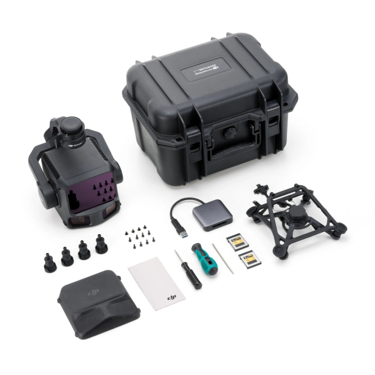
- In the Box
- FAQ
Long-Range LiDAR and Dual 100 MP Camera Payload for Enterprise-Grade Mapping
The DJI Zenmuse L3 LiDAR Camera a flagship long-range LiDAR and imaging payload designed for precision mapping, modeling, and inspection. Featuring a 1535 nm Class 1 laser and dual 100 MP Micro 4/3 cameras, it delivers up to 950 m range and 2–4 cm accuracy for enterprise-level surveying and digital-twin projects.
Built exclusively for the Matrice 400 RTK, the L3 integrates seamlessly into DJI Terra to generate point clouds, orthophotos, and 3D models within a unified workflow for faster, higher-quality data delivery.
Quick Look
- Long-range LiDAR system: 950 m @ 10% (100 kHz), 700 m @ 10% (350 kHz).
- High-efficiency mapping: covers up to 10 km² per flight or 100 km² per day
- Survey-grade accuracy: 2–4 cm typical precision for professional mapping.
- Adjustable point-rate control: 100 kHz – 2 MHz for detail or coverage balance.
- Configurable returns: 16 (100 / 350 kHz), 8 (1000 kHz), 4 (2000 kHz).
- Dual 100 MP Micro 4/3 cameras: produce orthophotos and colorized models.
- Real-time point-cloud preview: inspect onsite using DJI Pilot 2.
- Compact low-power design: 1.6 kg payload draws only 64 W typical power.
- Rugged IP54 build: operates from –20 °C to +50 °C.
- Streamlined workflow: integrates with DJI Terra and Modify.
- DJI Care Enterprise Plus: 1-Year coverage activated on first use.
High-Performance LiDAR with Extended Range and Precision
The Zenmuse L3 provides unmatched LiDAR reach and precision in its class. A smaller 41 mm beam diameter and 0.25 mrad divergence capture finer surface detail and sharper returns. Adjustable scan rates from 100 kHz to 2 MHz and up to 16 returns enable accurate modeling through vegetation or complex structures.
The IMU’s 0.01° pitch/roll and 0.02° heading accuracy, instant start-up, and in-flight auto-calibration ensure consistent, repeatable data for every mission.

Dual 100 MP Cameras and Field-Ready Durability
Two Micro 4/3 sensors capture ultra-high-resolution color imagery to enhance LiDAR datasets with photorealistic texture. The system delivers 1.2 cm GSD at 120 m AGL and 3 cm GSD at 300 m, producing crisp orthophotos and 3D models.
With an IP54 rating and operating range from -25 °C to +55 °C, the L3 performs in demanding conditions. Fully supported by DJI Terra and DJI Modify, it offers real-time point-cloud preview, on-site measurement, and automated accuracy checks — all backed by 1-Year DJI Care Enterprise Plus coverage.
Compatibility and Integration
- Supported aircraft: DJI Matrice 400 RTK only.
- Mounting system: DJI Skyport quick-plug single-port gimbal bracket.
- Dimensions: 192 × 162 × 202 mm.
- Data formats: LAS / LAZ point cloud, orthophoto, 3D model output.
- Software: DJI Terra for processing, DJI Modify for editing and analysis.
- Positioning integration: RTK / PPK fusion for georeferenced accuracy.
- Scanning modes: linear, star-shaped, non-repetitive patterns.
- Storage media: CF-Express Type B cards with included reader.
Zenmuse L3 Software Workflow & Subscription
Zenmuse L3 point cloud datasets can be processed in DJI Terra without any special authorization requirements. Log in to DJI Terra using any DJI account and proceed directly with LiDAR reconstruction.
A 3-month DJI Modify subscription is included with Zenmuse L3. Subscription details are delivered automatically via email or SMS to the contact information used during L3 activation.
Applications and Use Cases
- Power-line and tower inspection: delivers centimeter-level precision for utilities.
- Open-pit mine surveying: captures elevation and volume changes up to 830 m.
- Forestry and vegetation mapping: penetrates canopies for ground model generation.
- Topographic and engineering mapping: creates accurate terrain and as-built models.
- Archaeological documentation: reveals buried and heritage structures safely.
- Geological hazard monitoring: tracks slides and erosion in high-resolution 3D.
- Urban planning and digital twin creation: produces high-fidelity data for cities.
- Structural inspection: models bridges, dams, and steel frameworks in detail.
- Emergency response mapping: enables real-time area and volume measurement.
- Environmental research: supports hydrology and biomass analysis studies.
Zenmuse L3 vs Zenmuse L2: What Matters Most for Enterprise LiDAR Mapping
The right LiDAR payload depends on your altitude targets, corridor requirements, detection range expectations, and the imaging detail you need to pair with point cloud deliverables. Use the table below to match the platform and performance envelope to your workflow.
| Category | Zenmuse L3 | Zenmuse L2 |
|---|---|---|
| Primary role | High-altitude, long-range LiDAR for infrastructure and large-area coverage | Survey-grade LiDAR mapping with integrated RGB |
| Supported aircraft | DJI Matrice 400 only (requires Zenmuse L3 single gimbal connector) | Matrice 400, Matrice 350 RTK, Matrice 300 RTK (requires DJI RC Plus) |
| Dimensions (L×W×H) | 192×162×202 mm | 155×128×176 mm |
| Weight | 1.60 kg (without connector) + 145 g single gimbal connector | 905±5 g |
| Power (typical / max) | 64 W / 100 W | 28 W / 58 W |
| Ingress protection | IP54 | IP54 |
| Operating temperature | -20° to 50° C (-4° to 122° F) | -20° to 50° C (-4° to 122° F) |
| Storage temperature | -40° to 70° C (-40° to 158° F) | -20° to 60° C (-4° to 140° F) |
| System accuracy (typical) | At 120 m: Vertical 3 cm (RMSE), Horizontal 4 cm (RMSE) At 300 m: Vertical 5 cm (RMSE), Horizontal 7.5 cm (RMSE) |
Horizontal: 5 cm @150 m Vertical: 4 cm @150 m |
| Point cloud thickness | 1.2 cm @1σ (120 m nadir) 2 cm @1σ (300 m nadir) |
Not specified |
| LiDAR wavelength | 1535 nm | 905 nm |
| Detection range (provided test conditions) | 700 m @10% reflectivity, 350 kHz 950 m @10% reflectivity, 100 kHz 2000 m @80% reflectivity, 100 kHz |
450 m @50% reflectivity, 0 klx 250 m @10% reflectivity, 100 klx Max detection range: 500 m |
| Wire detection range | 21.6 mm steel core aluminum stranded wire: 300 m @100 klx, 350 kHz 18.4 mm black PVC insulated wire: 100 m @100 klx, 350 kHz |
Not specified |
| Point cloud rate / pulse options | Pulse rates: 100 kHz / 350 kHz / 1000 kHz / 2000 kHz Recommended altitude: <500 m (100 kHz), <300 m (350 kHz), <100 m (1000 kHz), <50 m (2000 kHz) |
Single return: up to 240,000 pts/s Multiple returns: up to 1,200,000 pts/s Laser pulse emission frequency: 240 kHz |
| Returns supported | Up to 16 returns (100/350 kHz), up to 8 returns (1000 kHz), 4 returns (2000 kHz) | Up to 5 returns |
| Scanning modes | Linear, Star-shaped, Non-repetitive | Non-repetitive scanning pattern, Repetitive scanning pattern |
| LiDAR FOV | Linear: H80° / V3° Star-shaped: H80° / V80° Non-repetitive: H80° / V80° |
Repetitive: H70° / V3° Non-repetitive: H70° / V75° |
| RGB mapping camera | 4/3 CMOS, up to 100 MP (dual camera system specified separately as combined FOV) | 4/3 CMOS, 20 MP |
| RGB FOV | Combined horizontal FOV (dual RGB cameras): 107° | 84° |
| RGB resolution | 100 MP: 12288×8192 25 MP: 6144×4096 |
Photos: 5280×3956 (20 MP) |
| Mechanical shutter durability | 500,000 actuations | 200,000 actuations |
| Storage media | CFexpress Type B (sequential write 1500 MB/s) | microSD (UHS-I U3, up to 256 GB) |
| Processing and formats | DJI Terra export: PNTS/LAS/LAZ/PLY/PCD/S3MB DJI Modify import: LAS |
DJI Terra export: PNTS/LAS/PLY/PCD/S3MB |
Selection guide
- Choose Zenmuse L2 for standard mapping altitudes, lighter payload power/weight, and flexible aircraft support across Matrice 300/350/400.
- Choose Zenmuse L3 for longer detection range, high-altitude mapping efficiency, explicit wire detection, higher return counts, and higher-resolution RGB capture.
- Choose based on workflow: microSD capture is simpler for smaller teams, while CFexpress capture is optimized for high-volume datasets.
The Zenmuse L3 is purpose-built for enterprise deployment, offering seamless compatibility with DJI’s Matrice 400 RTK ecosystem and software suite. Its robust design, fast startup, and integrated workflow deliver reliable survey-grade results under harsh conditions.
For organizations seeking accuracy, efficiency, and operational consistency, the L3 is a ready-to-deploy solution for modern data acquisition missions.
Zenmuse L3 advances the frontier of long-range aerial LiDAR by combining survey-grade performance, dual-camera imagery, and industrial reliability. It empowers teams to capture dense, accurate data faster and with greater confidence across any terrain.
Dronefly delivers the DJI Zenmuse L3 LiDAR Camera with comprehensive support and end-to-end services as an authorized DJI Enterprise dealer. Our technical specialists ensure smooth integration and post-sale assistance for your Matrice 400 RTK system.
Contact Dronefly today to order or schedule a demo.

