Skip to product information
1 of 6

DJI Mavic 3 Multispectral

DJI Mavic 3 Multispectral

Regular price $5,899.00
Regular price Sale price $5,899.00
Sale Sold out
SKU S-DJI-M3M MPN CP.EN.00000444.01 EAN 6941565950512
  • Does not include DJI Care Enterprise plan
  • 20MP 4/3 CMOS RGB camera
  • Four 5MP multispectral cameras
  • Sunlight sensor
  • RTK module for centimeter-level positioning
  • 43-minute max flight time
  • 200-hectare coverage in one flight
  • O3 transmission up to 15km
  • Various use cases in agriculture and natural resource management
  • Comes with DJI Terra Full-Featured 3-Month 1-Device (Gift) & DJI SmartFarm Platform (1-year access)
View full details
  • Description
  • Specifications
  • In the Box
  • FAQ

DJI Mavic 3 Multispectral for exceptional aerial surveying

It takes the right set of eyes to see problems that are hidden from view. Good thing the leader in drone technology now brings you the DJI Mavic 3 Multispectral.

DJI Mavic 3 Multispectral

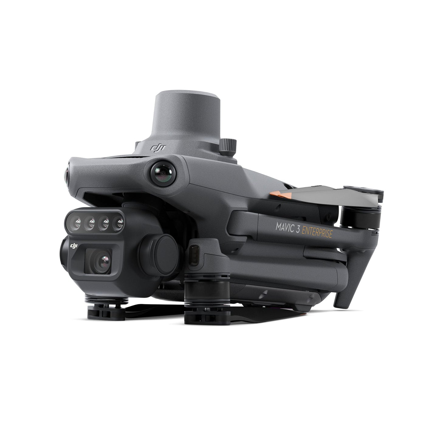
Power of RGB + multispectral cams

  • There are two ways for Mavic 3 Multispectral to see: one 20MP 4/3 CMOS RGB camera and four 5MP multispectral (green, red, red edge, and near infrared) cameras.
  • For crystal-clear crop growth analysis, it combines an RGB camera with a multispectral camera. Mavic 3M provides the data and precision that agricultural production management demands.
  • Precision aerial surveying, agricultural growth monitoring, and natural resource surveys are all made possible by these improved imaging systems.

Built-in sunlight sensor

  • For light adjustment of picture data during 2D reconstruction, the built-in sunlight sensor in DJI Mavic 3 Multispectral records solar irradiance in an image file.
  • As a result, the NDVI results are more accurate, and the accuracy and consistency of data collected over time are also improved.

RTK for centimeter-level positioning

  • An RTK module is included with Mavic 3M to enable centimeter-level positioning. To precisely pinpoint the location of each camera's imaging center, flight control, the camera, and the RTK module sync in a matter of microseconds.
  • Mavic 3M can now carry out very accurate aerial surveying without the need for ground control points.

Ultra-long battery life

  • Unlike other survey drones, the DJI Mavic 3 Multispectral has a maximum flight time of 43 minutes.
  • When fully charged, the aircraft can complete mapping operations over an area of 200 hectares in one flight.
  • You don’t even have to worry about getting back up in the air again because the battery supports fast charging.
  • You can use either the 100W Battery Charging Hub for high-efficiency multi-battery fast charging or the 88W aircraft recharging.

Fly with peace of mind

  • Smooth image transmission and a steady signal are guaranteed by Mavic 3M. In order to achieve 15km ultra-long transmission distances, the O3 transmission integrates two transmitting signals and four receiving signals.
  • For another layer of safety, the drone features omnidirectional obstacle sensing and terrain-follow mode.
  • The aircraft is equipped with several wide-FOV vision sensors, which enable obstacle avoidance by precisely detecting obstructions in all directions. In terrains with steep slopes, terrain-follow aerial surveying is simple to use.

Agricultural and natural resource applications

It’s a wonder that just one drone can be utilized in various agricultural and natural resource applications.

The DJI Mavic 3 Multispectral is so powerful you can fly it for different use cases such as the following:

  • orchard mapping
  • prescription mapping for croplands
  • intelligent field scouting
  • environmental monitoring
  • natural resources survey (water enrichment monitoring, forest distribution surveys, urban green area surveys, and more)
DJI Mavic 3 Multispectral

Free combos with every purchase

Each purchase of DJI Mavic 3 Multispectral comes with both of the following FREE combos:

  • DJI Terra Full-Featured 3-Month 1-Device(Gift)
  • DJI SmartFarm Platform (1-year access)

Ready to upgrade your organization’s drone program and operations? You’ll never go wrong with the all-new DJI Mavic 3 Multispectral.

The DJI Mavic 3 Multispectral Drone Bundle is the precision tool to be wished for by all professionals eager to have versatility and efficiency in their operations such as agriculture, land management, or environmental monitoring.

Aircraft

  • Net Weight (with propellers and RTK module): 951 g
  • Max Takeoff Weight: 1,050 g
  • Dimensions (Folded/Unfolded):
  • Folded: 223×96.3×122.2 mm
  • Unfolded: 347.5×283×139.6 mm
  • Diagonal Length: 380.1 mm
  • Max Ascent Speed:
  • Normal Mode: 6 m/s
  • Sport Mode: 8 m/s
  • Max Descent Speed:
  • Normal Mode: 6 m/s
  • Sport Mode: 6 m/s
  • Max Flight Speed:

    Forward: 21 m/s
    Sideways: 20 m/s
    Backward: 19 m/s

  • Normal Mode: 15 m/s
  • Sport Mode:
  • Max Wind Speed Resistance: 12 m/s
  • Max Take-off Altitude Above Sea Level: 6000 m
  • Max Flight Time (without wind): 43 minutes
  • Max Hover Time (without wind): 37 minutes
  • Max Flight Distance: 32 km
  • Max Tilt Angle:
  • Normal Mode: 30°
  • Sport Mode: 35°
  • Max Angular Velocity: 200°/s
  • GNSS: GPS + Galileo + BeiDou + GLONASS
  • Hovering Accuracy Range:
  • Vertical: ±0.1 m (Vision Positioning), ±0.5 m (GNSS), ±0.1 m (D-RTK)
  • Horizontal: ±0.3 m (Vision Positioning), ±0.5 m (GNSS), ±0.1 m (RTK)
  • Operating Temperature: -10° to 40° C
  • Internal Storage: N/A
  • Motor Model Number: 2008
  • Propeller Model Number: 9453F Enterprise Edition
  • Light Sensor: Built-in module

RGB Camera

  • Image Sensor: 4/3 CMOS, Effective Pixels: 20 MP
  • Lens:
  • FOV: 84°
  • Equivalent Focal Length: 24 mm
  • Aperture: f/2.8 to f/11
  • Focus: 1 m to ∞
  • ISO Range: 100-6400
  • Shutter Speed:
  • Electronic Shutter: 8-1/8000 s
  • Mechanical Shutter: 8-1/2000 s
  • Max Image Size: 5280×3956
  • Photo Shooting Mode:
  • Single Shot: 20 MP
  • Timelapse: 20 MP
  • Panorama: 20 MP
  • Video Resolution:
  • 4K: 3840×2160@30fps
  • FHD: 1920×1080@30fps
  • Max Video Bitrate:
  • 4K: 130 Mbps
  • FHD: 70 Mbps
  • Supported File System: exFAT
  • Image Format: JPEG/DNG (RAW)
  • Video Format: MP4 (MPEG-4 AVC/H.264)

Multispectral Camera

  • Image Sensor: 1/2.8-inch CMOS, Effective Pixels: 5 MP
  • Lens:
  • FOV: 73.91°
  • Equivalent Focal Length: 25 mm
  • Aperture: f/2.0
  • Focus: Fixed Focus
  • Multispectral Camera Bands:
  • Green (G): 560 ± 16 nm
  • Red (R): 650 ± 16 nm
  • Red Edge (RE): 730 ± 16 nm
  • Near Infrared (NIR): 860 ± 26 nm
  • Gain Range: 1x-32x
  • Shutter Speed: Electronic Shutter: 1/30~1/12800 s
  • Max Image Size: 2592×1944
  • Image Format: TIFF
  • Video Format: MP4 (MPEG-4 AVC/H.264)
  • Photo Shooting Mode:
  • Single Shot: 5 MP
  • Timelapse: 5 MP
  • Video Resolution: FHD 1920×1080@30fps
  • Max Video Bitrate: 60 Mbps

Battery

  • Capacity: 5000 mAh
  • Standard Voltage: 15.4 V
  • Max Charging Voltage: 17.6 V
  • Battery Type: LiPo 4S
  • Chemical System: Lithium Cobalt
  • Energy: 77 Wh
  • Weight: 335.5 g
  • Charging Temperature: 5° to 40° C

Battery Charger

  • Input: 100V to 240V (AC), 50Hz to 60Hz, 2.5A
  • Output Power: 100 W
  • Output:
  • Max output power of 100 W (total)
  • Dynamic allocation for two interfaces with max output power of one interface at 82 W

RTK Module

  • Dimensions: 50.2×40.2×66.2 mm
  • Weight: 24±2 g
  • Interface: USB-C
  • Power: Approx. 1.2 W
  • RTK Position Accuracy:
  • Horizontal: 1 cm + 1 ppm
  • Vertical: 1.5 cm + 1 ppm
  • 1x Aircraft (RTK module and microSD card installed)
  • 1x Remote controller
  • 1x Pair of propellers
  • 1x Charger
  • 1x Power cable
  • 1x USB-C cable
  • 1x USB-C to USB-C cable
  • 1x Carrying case
  • 1x Screwdriver
  • 1x Manuals


What is the purpose of the multispectral camera on the DJI Mavic 3 Multispectral?

It collects crop and vegetation data that can't be seen with RGB cameras. These insights are used for mapping, analysis, and precision agriculture. 

Can I use DJI Terra and SmartFarm together?

Yes. Terra handles the mapping and modeling; SmartFarm manages multispectral data and crop insights.

What’s the average area covered in one flight by Mavic 3 Multispectral?

Up to 200 hectares, depending on battery condition, altitude, and wind.

Does the Mavic 3 Multispectral support RTK for high-precision mapping?

Yes, the Mavic 3 Multispectral comes with an RTK module standard in the enterprise package, enabling high-accuracy mapping and surveying without needing extensive ground control points.

What are the spectral bands of the multispectral cameras on the Mavic 3M?

The bands are: Green (~550 nm ±16 nm), Red (~650 nm ±16 nm), Red Edge (~730 nm ±16 nm) and Near Infrared (~860 nm ±26 nm).

Is the Mavic 3M waterproof?

No.