


DJI Mavic 3T Advanced (M3TA)
DJI Mavic 3T Advanced (M3TA)

Couldn't load pickup availability


- Description
- Specifications
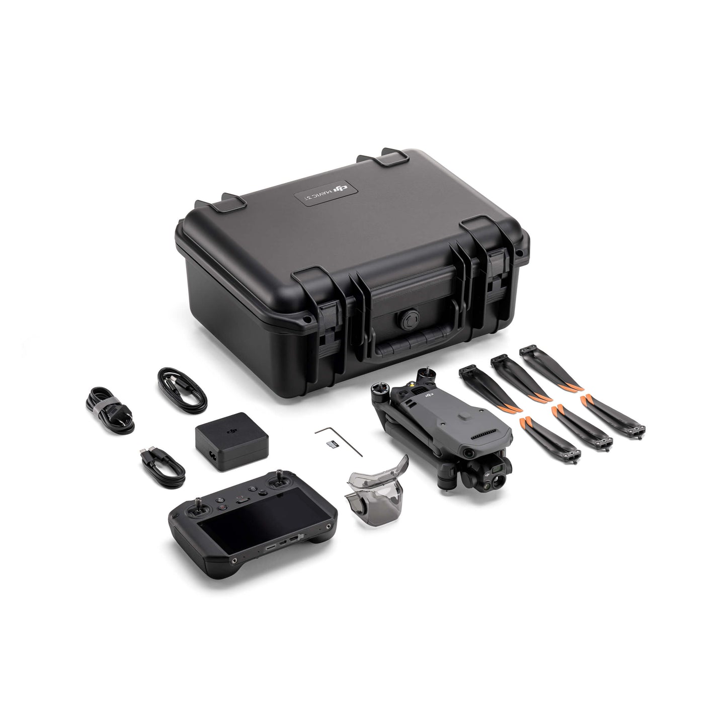
- In the Box
- FAQ
DJI Mavic 3TA: Advanced Thermal Imaging in a Portable Enterprise Drone
The DJI Mavic 3TA (also known as Mavic 3T Advanced) enhances the Mavic 3 Thermal platform with a more powerful thermal imaging system and extended operational control.
Its upgraded 41.2° DFOV, 60 mm equivalent thermal lens delivers finer detail at longer distances-ideal for inspection, search and rescue, and utility operations where precision matters most.
Product Highlights
- Triple-camera system: wide, telephoto, and advanced thermal sensors
- Enhanced thermal lens: 41.2° DFOV, 60 mm eq. focal length for refined accuracy
- 640 × 512 thermal resolution: reliable data for inspection and response
- 48 MP wide camera: high-resolution imaging for visual assessments
- 12 MP telephoto camera: 56× hybrid zoom for long-distance viewing
- Up to 45 minutes of flight time: extended endurance for missions
- RTK compatibility: centimeter-level precision for mapping and surveying
- Omnidirectional obstacle sensing: comprehensive situational safety
- O3 Enterprise transmission: strong, interference-resistant connection
- NOTE: Does not include DJI Care Enterprise coverage
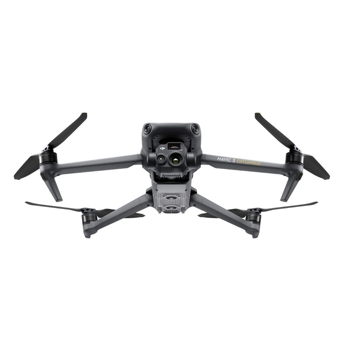
Enhanced clarity with triple-sensor capability
Equipped with a 48 MP wide camera, 12 MP telephoto lens with 56× hybrid zoom, and a 640 × 512 thermal camera, the Mavic 3TA captures synchronized visual and infrared data for professional-level analysis.
The upgraded thermal optics improve detection accuracy, while RTK compatibility enables centimeter-level mapping precision. With O3 Enterprise transmission and omnidirectional obstacle sensing, it ensures stable, reliable control in demanding conditions.
Endurance and portability combined
Weighing only 920 g, the Mavic 3TA offers up to 45 minutes of flight time and operates between −10 °C and 40 °C. Its foldable frame allows rapid deployment and easy transport for field operations.
Whether used in emergency response or infrastructure management, this drone delivers a powerful balance of image clarity, endurance, and safety.
Applications and Use Cases
- Power infrastructure inspection: detect component faults and heat anomalies
- Solar farm evaluation: locate malfunctioning panels via thermal contrast
- Search and rescue: identify heat sources through fog, smoke, or low light
- Firefighting support: track hotspots and fire behavior dynamically
- Industrial assessment: monitor equipment for irregular temperature changes
- Building analysis: detect insulation gaps or moisture issues
- Oil and gas inspection: reveal leaks and thermal inconsistencies
- Infrastructure management: inspect bridges, towers, and rooftops efficiently
The DJI Mavic 3TA combines advanced imaging technology and robust endurance in a lightweight, portable design. Built for professionals who depend on precision and reliability, it delivers consistent, high-quality data across a wide range of mission profiles.
Dronefly provides full enterprise integration and ongoing operational support for your fleet. Contact us today to buy the DJI Mavic 3TA and elevate your inspection and safety capabilities.

