

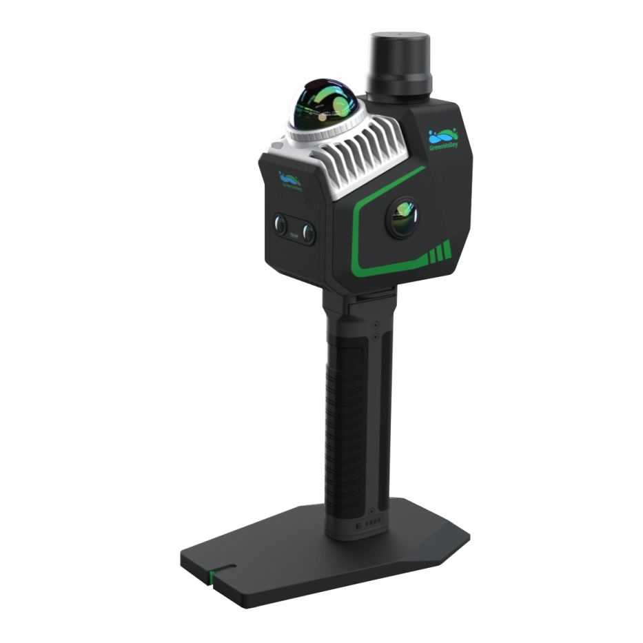
GreenValley LiGrip O2 Lite: Compact SLAM Mapping with GNSS Precision for the Field
The GreenValley LiGrip O2 Lite with GNSS and BP Modules is a handheld 3D LiDAR scanning system that brings real-time, centimeter-grade mapping to the palm of your hand. Designed for field crews, survey teams, and AEC professionals, it supports RTK-SLAM, PPK-SLAM, and GVI's advanced MLF-SLAM for seamless data capture-even in GPS-denied zones. Its lightweight form factor, flexible mounting options, and compatibility with LiDAR360 software make it a dependable workhorse for both interior and exterior scanning projects.
Precision Mapping in Any Environment
With integrated GNSS and multi-sensor SLAM technology, the LiGrip O2 Lite excels in environments with limited visual features, such as tunnels, mines, and riversides. Users can generate real-time, true-color point clouds with absolute geolocation, reducing post-processing time and improving workflow efficiency. Accessories like telescopic poles and frontpacks allow teams to adapt to dynamic conditions on-site, whether walking through warehouses or scaling terrain for facade surveys.
Ready-to-Deploy for Professional Workflows
Engineered for fast deployment and minimal setup, the LiGrip O2 Lite delivers actionable data from the field to your desk. When paired with LiDAR360MLS software, users gain a complete mapping pipeline-from scan to model. Dronefly's personalized consulting ensures your hardware fits your team's specific workflows and project needs, from stockpile management to detailed building documentation.
Key Features and Benefits
- GNSS + MLF-SLAM Integration: High-precision scanning in GPS-compromised areas
- All-in-One Mobile Unit: Combines LiDAR, imaging, and power for handheld use
- Accessory-Ready Design: Compatible with telescopic pole, adapter, and backpack module
- Real-Time LAZ Point Cloud Output: Streamlines data validation and QC in the field
- Lightweight and Ergonomic: Built for mobile data collection on foot
- Colorized Point Clouds with Coordinates: Visually rich and spatially accurate data
- Seamless Software Workflow: Integrates with LiDAR360 and LiDAR360MLS platforms
- Field-Ready Build: Designed for rugged, dynamic, and hard-to-map conditions
Applications and Use Cases
- Interior Mapping and Floor Plans: Fast, accurate scans of indoor environments
- Stockpile and Resource Monitoring: Capture volumes with minimal setup
- Construction and Facade Surveys: Document changes with colorized 3D visuals
- Tunnel and Underground Mapping: Navigate and capture in GPS-denied conditions
- Waterfront and Flood Zone Scanning: Map dynamic terrain with precision
- Infrastructure and Asset Inspection: Efficiently scan vertical and linear features
Why Buy from Dronefly
Dronefly supports you through every phase of your mapping program-from needs assessment and procurement to training and lifecycle support. As an authorized dealer for GVI, DJI, and FLIR, we deliver trusted hardware and software solutions tailored to your workflow. When you buy from Dronefly, you gain a long-term partner dedicated to keeping your operations productive, compliant, and future-ready.
Get in touch to optimize your 3D scanning projects with the LiGrip O2 Lite today.
Specifications
-
System Parameters
- Absolute Accuracy: <3 cm
- Relative Accuracy: <2 cm
- Repeat Accuracy: <2 cm
- Horizontality/Verticality: <0.025°
- Protection Level: IP64
- Storage Capacity: 512 GB SSD
- Port: Type-C
- Control Method: APP, Button
- Power Supply Method: Lithium Battery Powered
- Firmware Upgrade Method: OTA, Offline
- Battery Capacity: 3450 mAh
- Single Battery Life: 2 h
- Operating Temperature: -20℃ ~ 40℃
- Device Storage Temperature: -40℃ ~ 70℃
- Battery Storage Temperature (Recommended): 22℃ ~ 30℃
- Weight: 1.3 kg (with base, battery, and RTK module)
- Dimensions: 345 × 187 × 120 mm
-
LiDAR Sensor Parameters
- Laser: Mid360
- Laser Wavelength: 905 nm
- Scan Rate: 200,000 pts/s
- Detection Range:
- 40 m @ 10% reflectivity
- 70 m @ 80% reflectivity
- LiDAR Accuracy: 2 cm
- FOV: Horizontal 360°, Vertical -7° ~ 52°
- Safety Level: Class 1 (Eye-safe)
-
Camera Parameters
- Number of Cameras: 4
- Panoramic Camera: 12 MP × 2
- Visual Camera: 1.3 MP × 2
- Frame Rate: Adjustable
-
RTK Parameters
- Satellite Systems:
- BDS: B1I, B2I, B3I, B1C, B2b
- GPS: L1C/A, L2C, L2P(Y), L5
- GLONASS: G1, G2
- Galileo: E1, E5a, E5b, E6*
- QZSS: L1C/A, L2C, L5
- SBAS: L1C/A
- RTK Accuracy:
- Horizontal: 0.8 cm + 1 ppm
- Vertical: 1.5 cm + 1 ppm
- Channels: 1408
- Differential Data: RTCM V3.X
- RTK Differential Protocol: NTRIP
- RTK Data Format: .rtk
- Satellite Systems:
-
IMU Parameters
- Output Frequency: 200 Hz
- Post-Processing Position Accuracy:
- Horizontal: 0.01 m
- Vertical: 0.02 m
- Post-Processing Attitude Accuracy:
- Roll/Pitch: 0.005°
- Heading: 0.01°
-
Mapping Method
- Mapping Principles: MLF-SLAM, PPK-SLAM, RTK-SLAM, SLAM
- Real-Time Processing: Supported
- Real-Time Colorization: Supported
-
Output Specifications
- Colored Point Cloud: LAS, LiData
- Panoramic Image: imglist + JPG
- MESH: LOD-OSGB
- Gaussian Splatting: lisplat, ply
-
Telescopic Pole Adapter
- Weight: 300 g
- Supported Telescopic Pole Diameter: 25-25.5 mm
- Compatibility: LiGrip O Series (includes O1 Lite and O2 Lite)
-
Frontpack Kit Parameters
- Weight: 2.1 kg
- Outer Packaging Dimensions: 560 × 340 × 160 mm
- Compatibility: LiGrip H Series and O Series
-
Backpack Kit Parameters
- Weight: 3.9 kg
- Dimensions: 580 × 303 × 145 mm
- Dual Battery Power Display: Supported
- Hot Swap: Supported
- Compatibility: LiGrip O2 Series
In The Box
- 1x GreenValley LiGrip O2 Lite (with GNSS Module & Antenna) + BP Module

