Anyone who’s been keeping track of the drone industry in the last several years has seen, felt, or at least heard of the impact that drone thermal technology has been having in many different verticals.
From rescue applications to thermal inspections of solar panels and solar arrays, high-quality thermal cameras have been paired with aerial vehicles to provide accurate, non-contact temperature measurements from an aerial perspective. In plain English, thermal inspections from the sky.
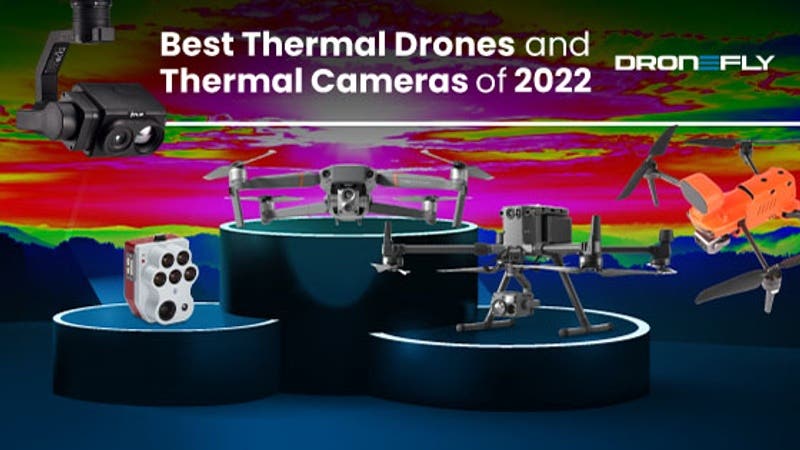
Previously, capturing accurate temperature measurements from above meant spending lots of time, money, and effort. Now, with compact and affordable aerial thermal solutions like the DJI Mavic 2 Enterprise Dual and the Matrice 300 RTK, detailed thermal measurements in roof inspections, power grid, and power line inspections are available. These analyses are readily available as a live map displayed right on the remote controller.
This is imagery accessible to anyone with a drone, allowing them to make accurate, informed decisions quicker, safer, and more efficiently than ever before.
Thermal - What The Heck Is It?
‘Thermal,’ of course, refers to heat, and the process of generating thermal images involves the collection and analysis of the heat signature of a given subject.
All objects radiate heat. Any subject in the field of view of a thermal sensor- from a missing person in search and rescue operations to hot and cold spots in industrial inspections, emits infrared radiation vibrating at various wavelengths: the faster the vibrations, the hotter the temperature.
Special thermal sensors in the cameras read these waves, and the data is processed to produce a visible image, acting much like traditional optical cameras. However, unlike regular RGB cameras, a thermal camera collects light waves that we can view with our eyes.

Thermal waves exist in an entirely different part of the light spectrum from the narrow band of visible wavelengths that humans can see on the electromagnetic spectrum. Thermal sensors can view the longer wavelengths of infrared and translate them into temperature data.

The difference in temperatures between subjects is displayed in the final images produced by the sensors. Different temperatures are shown as variations of color or brightness within a preset palate. Depending on the use case, different color palettes and resolutions are used for the image data, which is then processed and analyzed by a computer.

Why Is Thermal Imagery Such A Hot Commodity?
The ability to ‘see’ invisible heat with thermal cameras has proven to be an invaluable tool in countless fields for years, including:
Public Safety:
Thermal imagery has been critical to the success of the public safety sector. Part of the reason for the success of the thermal camera in these particular fields is its inherent night vision capabilities. Because they do not depend on visible light as our eyes do, thermal sensors can see through smoke and darkness.

This ability to see through smoke and darkness allows public safety agencies and their operators to gather real-time actionable data regardless of the time of day. From suspect tracking in law enforcement scenarios to rapid victim rescue in natural disasters and search and rescue missions to monitoring smoldering hot spots in firefighting, thermal imaging solutions are potent tools.
Industrial Inspection:
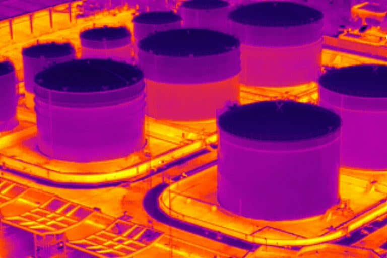
Thermal cameras have been just as instrumental in industrial inspection, where they have been used to track temperature differences during pipeline inspections and monitor infrared radiation from power lines. The ability to read heat and watch the temperature difference of a subject is an invaluable resource.
Real Estate:
Though drones with traditional cameras have been leveraged in the real estate market for years, thermal drones can also prove valuable. The ability to inspect a building or home for any insulation problems or leaks can have an enormous impact on an assessment.
Agriculture:
Thermal drones are aiding famers with agriculture as well. Thermal imaging allows for advanced insight into plant disease, the ripeness of produce, crop yield, irrigation issues and more. This valuable data can empower a farmer to take a proactive approach to these aspects, identifying and remedying problems before they get bad enough to be seen by conventional means.
Radiometric Thermal - To Display Heat Temperatures Or Not?
One of the most important decisions one needs to make about a thermal camera is whether they need radiometric capability or not.
Apart from the many different options available in terms and format, special modes for displaying a specific temperature range, zoom ability, etc., not having radiometric ability is a deal breaker for some.
Radiometric means a camera’s ability to measure and display the specific temperature of a subject in the field of view. Instead of just showing the difference in relative heat from one object to another, radiometric systems act as a sort of spot meter, displaying the specific temperature reading of an object.

The decision to use radiometric thermal imaging is largely based on the end-user and their requirements. There are some clear benefits to the option. In inspection scenarios, knowing the exact temperature of a specific point on a structure will allow an inspector to see if that equipment is operating within a safe temperature range.
Other scenarios may not need the additional data. In search and rescue missions, it’s not the relative temperature that matters- it’s whether their drone solution can locate a person. In these cases, a standard thermal camera without radiometric capability will be perfectly sufficient to detect the body heat of the missing person.
Thermal Sensor Resolution
What’s a camera review article without discussing sensor resolution, right? Camera resolution is a measurement of how many pixels the camera sensor has to record the image. The two most popular resolutions available for thermal sensors are 336 x 256 and 640 x 512. The higher the resolution, the more information each image contains: more pixels mean more details and the likelihood of more accurate measurements. It may be possible for you to use a lower-cost, lower-resolution camera, especially if you can get close to your target. However, to measure smaller targets from further away, a higher resolution will be required.
Field of View (FOV)
Another factor to consider when choosing a camera is the Field of View, or FOV. Camera FOV refers to the area that is visible to a camera at a given moment based on the lens. Some cameras have several lenses to choose from, depending on the application. A wide-angle lens with a FOV of at least 45 degrees is usually required for work performed up close. If you want to work from a distance, you need a telephoto lens (12° or 6°). Note that the wider the lens, the greater the FOV.

Refresh Rate
Another term you will most likely hear about when researching thermal cameras is the refresh rate, which is a number measured in hertz, or Hz. A hertz is a unit of frequency equal to one cycle per second, or one complete wave of alternating current or voltage.
The refresh rate is defined as the frequency at which the image on the screen is updated with new images. Therefore, 9Hz means the thermal image is updated nine times every second compared to 30Hz, which is updated 30 times every second.

Video has less blur when the refresh rate is higher. As thermal images are captured and analyzed to detect faults or anomalies, the 9Hz frequency is sufficient for most inspection applications. However, a 30Hz refresh rate makes it easy to discern movement on the screen and is therefore ideal for search and rescue (SAR) and law enforcement applications.
Most high-end thermal cameras like the FLIR Vue TZ20-R and DJI H20T have a 30Hz refresh rate for the best quality video image.
So Why A Thermal Drone?
There are thermal cameras and then there are thermal drones.
As the name suggests, thermal drone solutions use an infrared camera to create a thermal image from the air. The ability to see heat from above provides a critical perspective that has long been recognized as imperative to successful operations.
By gaining a more complete and accurate picture of the environment from this birds-eye view, important data can be gathered that would otherwise be missed. For instance, in routine maintenance of solar farms, it is critical to be able to monitor the temperature of all the panels simultaneously.
Without the ability to see a large array of the panels simultaneously, telling if one panel is reacting differently, heating up or cooling down more than the rest, under the same conditions would be nearly impossible.
Drone-based solutions in these applications allow for better monitoring of each panel and enable the fast and accurate inspection of the entire array.
But up until relatively recently, deploying a thermal camera in the air was prohibitively expensive and logistically difficult to widely adopt. Thermal cameras were traditionally large, heavy, and required the use of helicopters or airplanes to deploy. This made it incredibly costly and time-consuming to generate these invaluable images from thermal sensors.
That was until the drone industry began its boom, ultimately providing the necessary platform for thermal imagery to be taken to new heights. As the cost of drones came down while the technology and ease of use increased, it became clear that these devices could be used to create thermal images from above.
By designing thermal imaging systems for drones, the technology has become more affordable and easier to integrate with other devices. The leveraging of drone technology in this has been a true game-changer, allowing anyone to grab thermal images from above and see the world in a new light.
Whether for public safety in a natural disaster, industrial inspection, or pipeline monitoring, thermal drone packages have proven to be indispensable.
Which Companies Make Thermal Drone Solutions?
Teledyne FLIR
When one thinks of thermal, one of the first brands that come to mind is FLIR, which has been the gold standard in thermal imaging for years. The participation of FLIR in any aerial thermal imaging drone solution signals a level of quality and dependability that many thermal drone operators prefer over a thermal drone solution from another manufacturer such as DJI.
One aspect that made the XT series so popular is the fact that the thermal imagery in that product line is captured by FLIR thermal optics. Notable benefits include the ability to integrate the images from FLIR thermal products into industry-standard software vs proprietary software from DJI. Other benefits include FLIR MSX technology, a proprietary imaging system that overlays visible image edge details onto thermal images for enhanced clarity, safety and perspective.
Up until now, FLIR drone solutions were limited to payloads created for other manufacturers, like DJI. However, Teledyne FLIR recently launched the SIRAS drone, built to maximize speed and efficiency. It is ideal for industrial and utility inspection, search and rescue missions, public safety operations, and more.
Living up to their pristine reputation with imagery, FLIR did not skimp on the imaging capabilities of the SIRAS™. This drone features the TV128, comprised of a 16MP visible camera which zooms up to 128 times, along with the 640x512 pixel integrated radiometric Boson. The integrated radiometric Boson offers a 5x zoom, top-class thermal imagery, and continuous temperature measurement of every pixel in a scene.

The SIRAS also features Teledyne FLIR’s patented MSX® technology, which provides crucial information by overlaying thermal images with edge details from the visible camera in real time. This drone was built without geofencing restrictions, allowing it to get exactly where it needs to go to get the job done. This is especially important in search and rescue operations.
The SIRAS focuses heavily on data security. Data is stored on an SD card onboard the drone, and it does not offer wifi, bluetooth or cellular transmission capabilities. Businesses are concerned with where their data is going and data security, and rightfully so. With this drone, data goes on the SD card on the drone, offering users peace of mind.
Pilots are also able to operate the SIRAS without creating an online profile. This combined with its 1-minute startup time, hot swappable batteries, 31-minute flight time, and front collision avoidance feature, makes the SIRAS very easy to get started with, super efficient, and effective in poor weather conditions.
Luckily, the number of options is growing for aerial experts looking to use thermal drones equipped with FLIR thermal imaging cameras. One of the more interesting products offered by FLIR is the VUE TZ20-R payload, compatible exclusively with the DJI M300 RTK. The ‘R’ in TZ20-R represents the new radiometric upgrade to the non-radiometric model that preceded it, the VUE TZ20.
The TZ20 is characterized by its unique thermal zoom feature. Dual Boson Thermal sensors of 640 x 512 pixel resolution are used in this thermal imaging system. The first of the two high quality sensors is paired with a 4.9mm wide angle lens, providing a 95º viewing angle and maximum situational awareness. In missions requiring the observation of large areas of open space, this wide angle lens is especially useful. A longer 24mm lens is combined with the second sensor to produce an 18º field of view.
These imaging elements provide the major distinction and advantage of the TZ20 – its zoom capabilities. With this system, you’ll be able to achieve the equivalent of up to 5x optical zoom and 20x digital zoom. Extremely clear images can be obtained with the TZ20 series from a great distance by zooming in on objects or individuals. By comparison, the equivalent digital zoom functionality of the competitors is noticeably less clear.
DJI
Some of the most popular thermal drone technology comes from DJI.
DJI is known for its thermal imaging drones, such as the DJI Mavic 2 Enterprise Advanced. Presenting a significant upgrade to the previous Mavic 2 Enterprise Dual, this drone combines a high-resolution 640 x 512 radiometric thermal camera with an RGB camera that captures high-quality visible images at a video recording resolution of up to 4K and offers an amazing JPEG photo resolution of 48MP. The M2EA is incredibly easy to fly and has integrated advanced obstacle avoidance capabilities. This thermal drone is a newer, smaller alternative to the previous generation thermal cameras like the DJI Zenmuse XT and XT2, which require a larger drone to use. And with the M2EA’s ability to use an optional RTK package, this little drone can bring the accuracy needed for the most demanding inspection jobs.

DJI’s line of larger enterprise drones is the Matrice series. The DJI Matrice 200 and Matrice 210 v2 have spent years as the industry standard for commercial drone pilots. In 2020, DJI released the Matrice 300 RTK, which is the newest and most capable enterprise drone in the DJI lineup.

The DJI Matrice 300 RTK is also the most flexible and versatile, boasting a long flight time and incredibly advanced collision avoidance and smart track capabilities. The M300 is able to carry a wide variety of payloads from DJI, such as the P1 full-frame photogrammetry camera, the L1 LiDAR sensor, H20, and the H20T hybrid camera, which offers a visible zoom camera, a laser rangefinder and thermal imaging using DJI’s own proprietary sensor.
The DJI Matrice 300 RTK is also capable of supporting thermal imaging cameras from well-respected third parties like FLIR.
PARROT
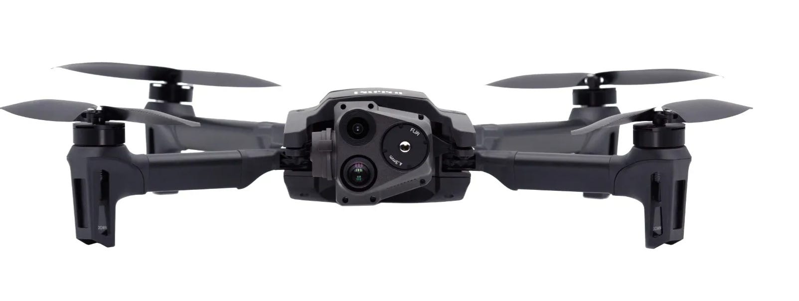
Originally created with the US Army, the Parrot ANAFI USA is an ideal drone for first responders, firefighters, SAR teams, and security teams. Versatility is on full display, with a combination of a 32x optical zoom system, two 21-megapixel cameras, and a 320 x 256 FLIR Boson® 320 LWIR thermal sensor.
Anafi USA's thermal imaging capabilities can be utilized to find victims and gather data during firefighting. The drone's small size and lightweight design make it easier to transfer and set up in remote locations.
In emergency situations, every second counts. First responders can deploy the Parrot Anafi USA in 55 seconds. The Anafi USA's safe radio link and simple controls make it ideal for speedy operations.
Parrot Anafi USA is an indoor/outdoor drone. It's straightforward to use and perfect for any situation because it lands in your hand. The Anafi USA's GPS and long battery life provide you peace of mind, particularly indoors.
The ANAFI USA puts a premium on data security. Secure Digital (SD) card encryption technology protects photos and movies even if the drone or SD card are lost.
ANAFI USA's secure WPA2 Wi-Fi connects the remote controller and drone. Signed firmware prevents software modification. Parrot uses Wi-Fi, WPA2, RTP/RTSP, H.264, and GUTMA to protect recorded data.
Without user authorization, no data is shared. The option is available to save flight logs and data on secure servers in Europe.
AUTEL
FLIR doesn’t only provide thermal technology for its own brand. It also provides thermal cores for drone manufacturers like Autel. The Autel EVO II series, with the EVO II Dual R and the EVO II 640T, are both solid competitors to DJI drones. Some of the benefits of Autel’s drones compared to DJI’s is the lack of Geofencing and forced firmware updates, which could potentially hamper a drone pilot’s ability to respond quickly to an emergency situation. Having a FLIR thermal core may also be a deciding factor for some who would prefer not to use DJI’s own thermal sensors. The EVO II 640T boasts a dual thermal/RGB camera with a 640×512 thermal resolution at 30hz and a 1/2″ CMOS sensor providing 8K video and 48MP images in several photo modes. Combined with an impressive collision avoidance system and great customer service, Autel is a worthy competitor to the reigning thermal drone king, DJI.

MicaSense
MicaSense is primarily known for their multispectral sensors, which collect data from multiple bands of the light spectrum, both visible and non-visible. Our perception of color in light is determined by the wavelength of that light, as we discussed earlier. Light is absorbed and reflected differently by plants based on wavelength, typically absorbing more blue light and red light, and reflecting green light. Moreover, near-infrared light (NIR) is reflected a great deal more by them.
A plant’s reflectance is defined as its ability to reflect light. Multispectral cameras capture and measure the reflectance at different wavelengths of light, thereby allowing the identification of stress areas in crops and providing an objective measure of plant growth. There are multiple imagers in multispectral cameras, each with a specialized filter that enables it to capture a particular wavelength of light. An image is produced by the camera for each wavelength. This wavelength range is typically restricted to spectral bands in the blue, green, red, red edge, and near-IR ranges. We then stitch together these sets of images to create geographically accurate mosaics, which have multiple layers for each wavelength. These layers are subsequently combined mathematically to yield vegetation indices. With the new Altum-PT, MicaSense also enables the simultaneous capture of thermal images, which have significantly higher wavelengths on the light spectrum. The addition of thermal imaging to an already robust complement of visible and non-visible light measurement makes the Altum-PT one of the most data intensive sensor on our list, specifically suited for professionals working in agriculture, forestry or environmental monitoring.


Regardless of the brand or model, it’s clear thermal drones are a vital tool for many industries. This incredible technology can help increase safety, reduce costs and create a better end product for the user.
Whether you’re in need of a small thermal drone with high-quality images like the Mavic 2 Enterprise Advanced or the Autel EVO II 640T, or larger enterprise models like the DJI M300 RTK that can support more robust payloads like the DJI H20T or FLIR’s VUE TZ20-R, there is something available to suit your needs.
If you want to learn more about how thermal drones can help create a complete solution for your unique vertical, contact us today! One of our friendly and knowledgeable drone experts would be happy to help you!


