


ACSL SOTEN Survey RTK Bundle Plus
ACSL SOTEN Survey RTK Bundle Plus

Couldn't load pickup availability


- Description
- Specifications
- In the Box
- FAQ
ACSL SOTEN Survey RTK Bundle Plus: NDAA-Compliant RTK Mapping System With Five Batteries and IP43 Weather Resistance
The ACSL SOTEN Survey RTK Bundle Plus is a fully configured aerial mapping and inspection system engineered for enterprise and government operators who require a verified NDAA-compliant platform with a security architecture that holds up to professional scrutiny.
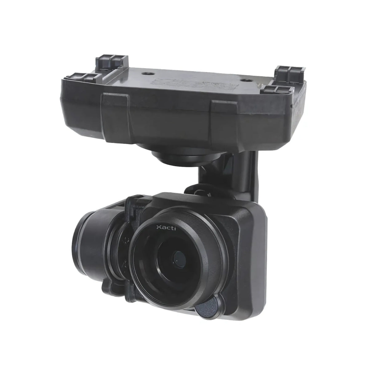
Designed and manufactured in Japan by ACSL, the SOTEN integrates a 20 MP 1-inch mechanical shutter camera, an RTK module for precision positioning, and the NDAA-compliant TAITEN Smart Controller into a compact, foldable airframe powered by Yamaha-developed motors.
The Plus variant extends operational capacity with five smart batteries and a triple battery charger, giving program managers the power reserves to run continuous multi-sortie missions without scheduling recharge windows around field operations.
Key Features and Benefits
- NDAA compliance: Japan-manufactured platform with ISO 15408–grade encryption for secure U.S. program deployment.
- RTK precision: included RTK module supports precise georeferenced positioning for mapping and survey workflows.
- Mechanical shutter: 20 MP 1-inch sensor eliminates rolling shutter distortion during lateral grid mapping passes.
- Five batteries included: Plus variant provides sustained multi-sortie capacity without mid-day recharging interruptions.
- IP43 protection: aircraft rated for rain, dust, and debris with camera, gimbal, and battery fully installed.
- One-touch payload swap: field-exchangeable camera system covers four mission types on a single airframe.
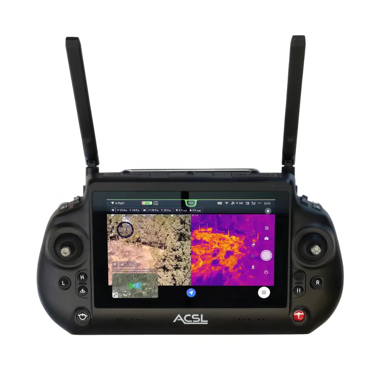
- TAITEN controller: IP54-rated ground station with 1,500-nit display, AES-256 link, and 8-hour runtime.
- Multi-controller pairing: up to three TAITEN controllers connect simultaneously for team-based flight operations.
- Obstacle sensing: stereo cameras and infrared sensors cover forward, upward, and downward detection zones.
- Data security: onboard recording encryption and no forced cloud dependencies protect mission data at rest.
For fleet integrators and enterprise program managers, the SOTEN's value is defined as much by what it does not do as by what it does. There are no forced cloud dependencies, no third-party data routing, and no ambiguity about where flight data and imagery end up.
ISO 15408–grade encryption governs communications and onboard data storage at the hardware level, with operator-controlled encryption on the recording media and AES-256 encrypted dual-band link on the TAITEN controller.
The one-touch swappable payload system supports four distinct camera configurations — standard, thermal, multispectral, and optical zoom — allowing a single SOTEN airframe to serve mapping, inspection, public safety, and agricultural workflows as program requirements evolve, without acquiring additional aircraft.
An NDAA-Compliant Platform Built for Program-Level Deployment
Enterprise programs evaluating drone platforms for sensitive operations need more than flight performance specs, they need a system whose data architecture can withstand procurement review and operational security requirements.
The SOTEN is designed from the ground up to meet that standard. Its ISO 15408–grade security framework governs the full data chain from transmission to storage, with no reliance on external cloud infrastructure. The TAITEN Smart Controller operates on ACSL's encrypted Fides-Link dual-band system with a 6-mile-plus range in low-interference conditions, pairing AES-256 link encryption with a ruggedized IP54 housing and an Android 13 platform running the ACSL TAKEOFF app.
For fleet programs requiring team-based operations, up to three TAITEN controllers can connect to a single aircraft simultaneously, enabling coordinated handoffs and line-of-sight compliance across large or complex operational areas without additional ground infrastructure.
Compatibility and System Integration
- SAMO Thermal/Optical Payload: Teledyne FLIR Hadron 640R with 640 × 512 radiometric thermal sensor and 64 MP visible camera. (Sold separately)
- Multispectral Camera: 20 MP 1-inch mechanical shutter sensor capturing 550 nm, 680 nm, and 850 nm spectral bands. (Sold separately)
- Optical Zoom Camera: 25× total zoom (2.5× optical, 10× digital) and 12 MP across an 18–45 mm focal range. (Sold separately)
- LTE Comms Module: optional accessory enabling extended-range and BVLOS-ready communications in remote areas. (Sold separately)
- ACSL TAKEOFF app: pre-installed on TAITEN for integrated flight operations, camera control, and mission planning.
- Multi-controller pairing: three TAITEN controllers supported simultaneously for coordinated team-based operations.
- GPC hard case: included transport and storage solution for protected deployment across job sites.
- NDAA-compliant ecosystem: airframe, controller, RTK module, and camera all meet NDAA procurement requirements.
Applications and Use Cases
- Government and defense inspection: NDAA compliance and ISO 15408 encryption meet sensitive U.S. program procurement standards.
- Precision mapping and surveying: RTK module and mechanical shutter camera support accurate georeferenced aerial data collection.
- Critical infrastructure inspection: one-touch payload swap and optical zoom camera enable detailed remote documentation at safe standoff distances.
- Disaster and emergency response: IP43 weather resistance and sub-minute deployment support time-sensitive field operations.
- Multi-sensor program deployment: single airframe supports mapping, thermal, multispectral, and zoom workflows across evolving mission requirements.
- Team-based operations: three-controller pairing enables coordinated crew deployments with seamless aircraft handoffs in the field.
The SOTEN Survey RTK Bundle Plus is configured for programs that need a compliant, weather-resistant, multi-mission platform with enough on-site power capacity to complete a full day of operations without returning to base.
Its security architecture addresses the data handling requirements that sensitive government and enterprise programs impose, and its one-touch payload system gives fleet managers the flexibility to adapt sensor configurations as mission profiles change over time.
Dronefly's enterprise team works directly with program managers, fleet integrators, and government procurement leads to configure SOTEN systems around specific operational requirements, payload combinations, and compliance documentation needs.
The Survey RTK Bundle Plus represents the most operationally complete entry point into the SOTEN platform. Order now or contact Dronefly today to discuss program configuration and deployment planning.

