


Autel EVO II Pro 6K RTK Rugged Bundle V3
Autel EVO II Pro 6K RTK Rugged Bundle V3

Couldn't load pickup availability


- Description
- Specifications
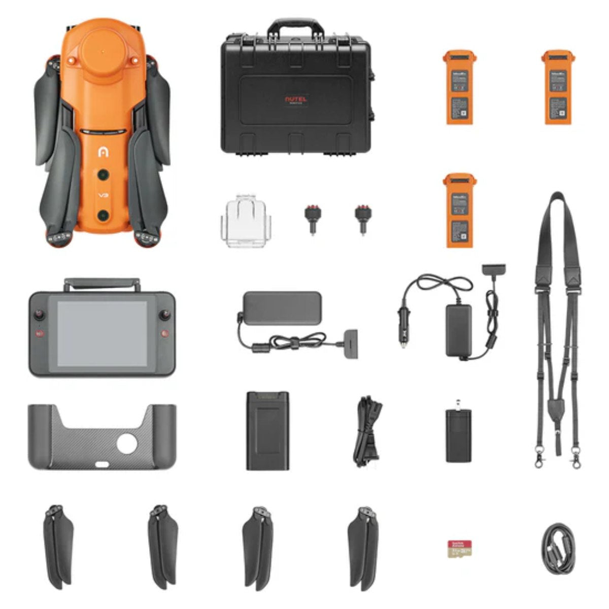
- In the Box
- FAQ
RTK Drone for Precision Surveying, Mapping, and Infrastructure Inspection
The Autel EVO II Pro 6K RTK Rugged Bundle V3 is engineered for professionals who require accurate aerial data for surveying, photogrammetry, engineering, construction, and infrastructure inspection.
Equipped with an integrated RTK module, the aircraft delivers centimeter-level positioning while supporting PPK, time synchronization, NTRIP networks, and third-party base stations to improve mapping accuracy and streamline data collection.
Combined with a 20 MP 1-inch CMOS camera, 6K Ultra HD video, and intelligent flight planning tools, it provides an efficient platform for capturing reliable geospatial data across demanding job sites.
Standout Features
- Integrated RTK module with centimeter-level positioning
- Supports RTK, PPK, time synchronization, and NTRIP workflows
- Compatible with third-party RTK base stations
- 20 MP 1-inch CMOS sensor with 6K Ultra HD video
- Adjustable aperture from f/2.8 to f/11
- 10-bit A-Log for greater post-production flexibility
- Up to 38 minutes of maximum flight time
- SkyLink 2.0 transmission up to 9 miles
- Maximum flight speed of 45 mph
- 360° obstacle avoidance with 19 sensor groups
- Autel Explorer mission planning with polygon and rectangular mapping
- Includes Smart Controller V3 and rugged carrying case
The RTK Rugged Bundle V3 features SkyLink 2.0 video transmission with a range of up to 9 miles, an industry-leading 38-minute flight time, a maximum speed of 45 mph, and 360° obstacle avoidance powered by 19 groups of sensors.
Whether producing orthomosaics, inspecting powerlines, documenting construction progress, or creating 3D site models, this rugged drone package combines precision, reliability, and portability for professional aerial operations.
Centimeter-Level Positioning for Professional Surveying
The integrated RTK module delivers real-time centimeter-level positioning to improve the accuracy of aerial surveys and mapping missions. In addition to RTK correction, the system supports Post-Processed Kinematic (PPK) workflows and time synchronization, allowing the aircraft to record satellite observations, camera exposure parameters, and flight data for highly accurate geospatial processing.
The EVO II Pro 6K RTK Rugged Bundle V3 also supports NTRIP correction services and is compatible with third-party RTK base stations, giving organizations the flexibility to integrate the aircraft into existing surveying workflows.
For many mapping projects, operators can achieve centimeter-grade accuracy without relying on traditional ground control points, helping reduce setup time and improve field efficiency.
Advanced Mapping With Autel Explorer
The included Autel Explorer software provides intelligent flight planning tools designed specifically for professional mapping missions. Users can create rectangular or polygon flight plans while supporting double-grid mapping for improved coverage and additional image angles.
To improve productivity during larger projects, the software supports flight profile saving, allowing operators to resume multi-battery missions without redefining mission parameters.
Photo replication also enables repeat inspections by duplicating previous camera, gimbal, and aircraft settings, making long-term asset monitoring more consistent and efficient.
Capture Detailed 6K Survey Data
The EVO II Pro 6K RTK Rugged Bundle V3 features a 20 MP 1-inch CMOS sensor capable of recording 6K Ultra HD video and high-resolution still imagery for photogrammetry, inspections, and engineering documentation.
An adjustable f/2.8 to f/11 aperture allows greater control over exposure in changing lighting conditions, while support for 10-bit A-Log provides increased flexibility during post-processing and color grading.
The camera also offers 3× lossless zoom and 16× digital zoom, enabling operators to inspect structures from safer distances while maintaining excellent image quality.
Reliable Flight Performance for Demanding Missions
Designed for extended field operations, the aircraft delivers up to 38 minutes of maximum flight time, allowing operators to cover larger areas before changing batteries.
A maximum speed of 45 mph helps teams reach remote inspection sites quickly, while wind resistance of up to 27 mph improves stability during challenging weather conditions.
The SkyLink 2.0 transmission system provides dependable HD video transmission up to 9 miles under FCC conditions while using automatic frequency hopping across 2.4 GHz, 5.8 GHz, and 900 MHz (where permitted) to reduce interference and maintain a stable connection.
Intelligent Flight Safety
The EVO II Pro 6K RTK Rugged Bundle V3 uses 360° obstacle avoidance supported by 19 groups of sensors, including visual sensors, ultrasonic sensors, IMUs, and the main camera.
Together, these systems generate three-dimensional environmental awareness to assist with obstacle detection and safer flight planning.
The aircraft also includes an integrated ADS-B receiver, providing pilots with alerts for nearby manned aircraft to enhance airspace awareness during professional operations.
Smart Controller V3 Included
The Rugged Bundle includes the Autel Smart Controller V3, designed for professional field operations. Its 7.9-inch display with 2,000 nits of brightness remains easy to view under direct sunlight, while the customized Android operating system supports third-party applications for flexible mission workflows.
The controller also features SkyLink 2.0 transmission technology, an IP43 weather-resistance rating, and up to 4.5 hours of operating time, making it well suited for extended surveying and inspection projects.
Mission Applications
The Autel EVO II Pro 6K RTK Rugged Bundle V3 supports a wide variety of professional aerial data collection and inspection tasks, including:
- Photogrammetry
- Land surveying
- Construction progress monitoring
- Civil engineering
- Powerline inspection
- Utility inspection
- Infrastructure inspection
- GIS mapping
- Environmental monitoring
- Mining operations
- Law enforcement
- Firefighting and emergency response
Compare EVO II Pro V3 Bundles
While every EVO II Pro V3 bundle features the same professional imaging platform, each package is optimized for different mission requirements.
| Feature | EVO II Pro 6K RTK Rugged Bundle V3 | EVO II Pro 6K Rugged Bundle V3 | EVO II Pro 6K Enterprise Bundle V3 |
|---|---|---|---|
| EVO II Pro V3 aircraft | ✓ | ✓ | ✓ |
| 1" Sony CMOS 20MP camera | ✓ | ✓ | ✓ |
| 6K video | ✓ | ✓ | ✓ |
| Rugged carrying case | ✓ | ✓ | ✓ |
| Three Intelligent Flight Batteries | ✓ | ✓ | ✓ |
| RTK module included | ✓ | ✗ | ✗ |
| PPK support | ✓ | ✗ | ✗ |
| NTRIP support | ✓ | ✗ | ✗ |
| Spotlight included | ✗ | ✗ | ✓ |
| Loudspeaker included | ✗ | ✗ | ✓ |
| Strobe included | ✗ | ✗ | ✓ |
| RTK module support | Included | Not included | Optional |
| Primary application | Surveying & mapping | General imaging & inspection | Public safety & enterprise operations |
The comparison above highlights the key differences between the Rugged Bundle, RTK Rugged Bundle, and Enterprise Bundle to help you choose the best configuration for your workflow.
Professional Accuracy From Planning to Processing
From mission planning and centimeter-level positioning to high-resolution image capture and advanced post-processing, the Autel EVO II Pro 6K RTK Rugged Bundle V3 provides a complete aerial mapping solution for geospatial professionals.
With integrated RTK technology, intelligent mapping tools, a professional imaging system, and a rugged field-ready package, it is built to help organizations collect accurate data, improve productivity, and make better-informed decisions across surveying, engineering, and inspection projects.


