Skip to product information
1 of 4

DJI Matrice 4E (Demo Unit)

DJI Matrice 4E (Demo Unit)

Regular price $3,299.00
Regular price $5,249.00 Sale price $3,299.00
Sale Sold out
SKU S-DJI-M4E-DEMO MPN CP.EN.00000574.01
  • Demo unit in like-new condition, cosmetic engraving, fully operational mapping platform.
  • Triple-sensor system with 20 MP wide, 48 MP medium tele, and 48 MP tele.
  • Laser rangefinder reaches 1,800 m for field distance measurement without GCPs.
  • RTK Fix accuracy of 1 cm + 1 ppm horizontal for survey-grade data collection.
  • Wide-angle camera supports GCP-free precision mapping with RTK enabled.
  • Forty-nine minutes of flight time per standard battery charge at sea level.
  • Mechanical shutter eliminates rolling distortion on lateral grid mapping passes.
  • O4 Enterprise transmission with 25 km range and 1080p live view.
  • Omnidirectional obstacle sensing active at speeds up to 21 m/s.
View full details
  • Description
  • Specifications
  • In the Box
  • FAQ

DJI Matrice 4E (Demo Unit): Triple-Sensor Mapping Drone With 49-Minute Flight Time and Laser Rangefinder

The DJI Matrice 4E is DJI's purpose-built geospatial platform within the Matrice 4 Series: a compact, folding enterprise drone configured from the ground up for surveying, mapping, construction documentation, and mining workflows that demand centimeter-level data accuracy without the deployment weight of larger aircraft.

Its integrated imaging system combines a 4/3-inch 20 MP wide-angle camera with mechanical shutter, a 48 MP medium telephoto at 70 mm equivalent, and a 48 MP telephoto at 168 mm equivalent with 16× optical zoom and 112× hybrid zoom, all stabilized on a 3-axis gimbal. A 1,800 m (5,906 ft) laser rangefinder and RTK Fix accuracy of 1 cm + 1 ppm horizontal complete a sensor package that reduces post-processing dependencies and tightens deliverable timelines for geospatial programs.

Key Features and Benefits

  • Triple-sensor imaging: 20 MP wide, 48 MP medium tele, and 48 MP tele cameras on one stabilized gimbal.
  • Laser rangefinder: measures distances to 1,800 m (5,906 ft) at 1 Hz with no ground contact required.
  • RTK positioning: 1 cm + 1 ppm horizontal Fix accuracy supports repeatable survey-grade data collection.
  • GCP-free mapping: wide-angle camera enables precision mapping missions without ground control points.
  • Flight endurance: 49-minute flight time per charge extends coverage area per sortie across large sites.
  • Omnidirectional sensing: binocular vision and 3D infrared cover all directions at flight speeds up to 21 m/s.
  • O4 Enterprise transmission: 25 km range (FCC) with 8-antenna system and 1080p/30fps live view.
  • Mechanical shutter: eliminates rolling shutter distortion during grid mapping passes at speed.
  • Compact deployment: folds to 260.6 × 113.7 × 138.4 mm for transport across multiple sites per day.
  • Hybrid zoom: 16× optical telephoto with 112× hybrid zoom supports detailed remote target inspection.

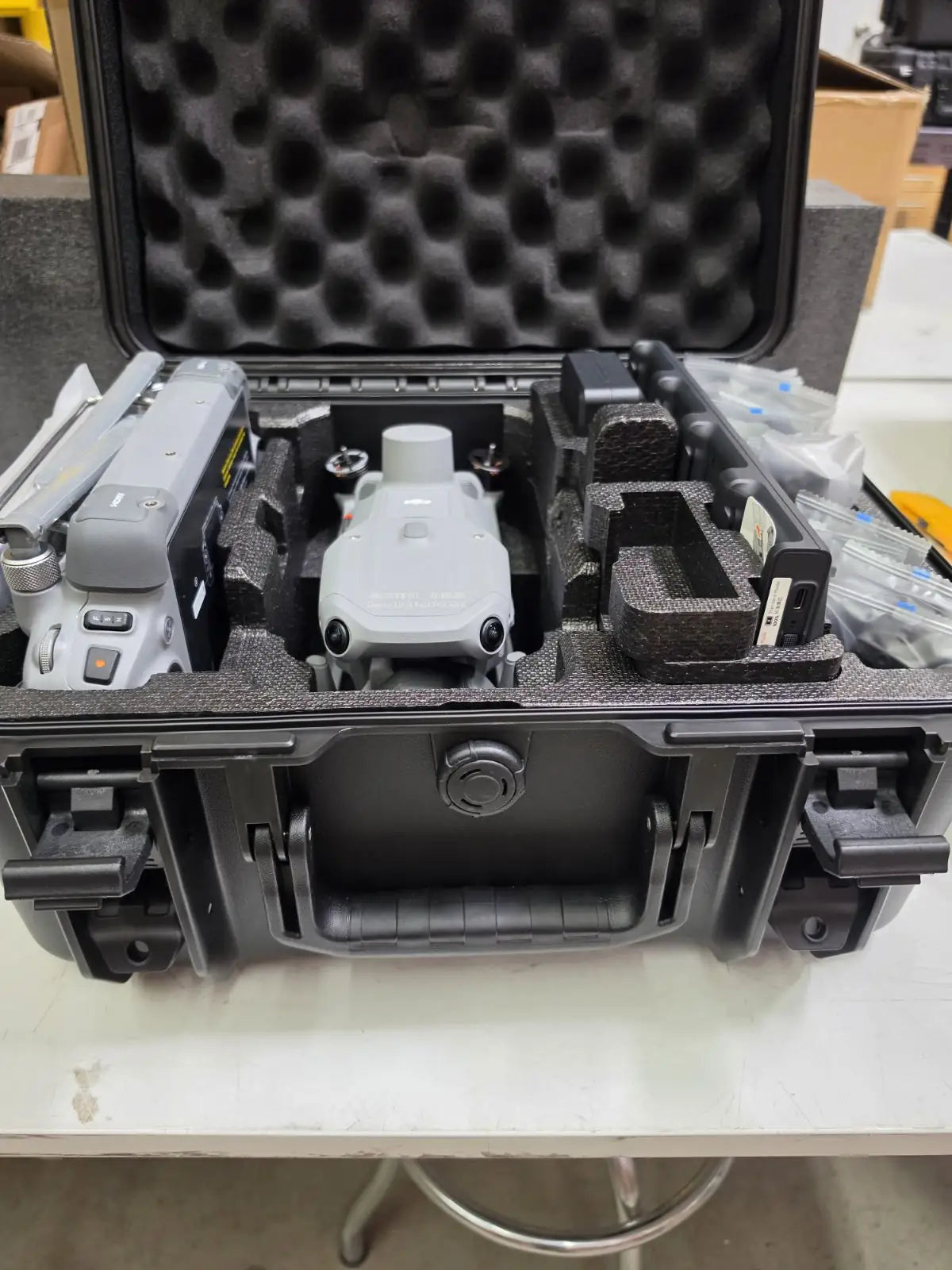
This listing is for a like-new factory demo unit. A permanent factory engraving on the aircraft body reads "Demo Unit Not For Sale," with the equivalent text in Chinese. The marking is cosmetic only and carries no effect on flight systems, imaging, positioning, or software compatibility.

The aircraft is mechanically and electronically identical to a standard production M4E. Included with this unit: one Matrice 4 Series Intelligent Flight Battery, three propeller pairs, the DJI RC Plus 2 Enterprise Edition controller, charger, charging hub, and the official DJI Matrice 4E carry case. The DJI Terra license is not included with this demo unit and requires separate procurement. The M4E carries no IP ingress protection rating and is not rated for operation in rain or wet conditions.

Imaging Precision Engineered for Geospatial Programs

Program managers evaluating a mapping platform need to account for the full data pipeline, not just flight performance. The M4E is configured to reduce friction at every stage. The mechanical shutter on the wide camera eliminates the image distortion that rolling shutters introduce during lateral grid flights, improving orthomosaic output quality without requiring slower airspeeds. RAW capture on the wide camera preserves radiometric data for workflows that require color-calibrated deliverables.

The 0.5-second minimum photo interval supports high-overlap grid passes at standard mapping speeds, and the GNSS and vision integrated positioning system enables RTH without a GNSS signal, keeping aircraft recovery reliable even in RF-contested environments. RTK services are bound to the remote controller, allowing consistent positioning reference across multi-flight data collection campaigns without reconfiguring base station assignments.

Compatibility and System Integration

  • D-RTK 3 Multifunctional Station: differential correction base for centimeter-level RTK Fix positioning in the field.
  • DJI Terra software: post-flight processing platform for 2D orthomosaics, 3D models, and point cloud outputs.
  • DJI FlightHub 2: cloud-based fleet management for multi-aircraft coordination and live mission oversight.
  • DJI Cellular Dongle 2: optional 4G/LTE module enabling network RTK and expanded connectivity in remote areas.
  • DJI AL1 Spotlight: E-Port compatible accessory for low-light and nighttime operational support.
  • DJI AS1 Speaker: E-Port compatible accessory for ground-level communication during flight operations.
  • RC Plus 2 Enterprise Enhanced Edition: optional upgraded controller with expanded accessory interface compatibility.
  • Payload SDK and Cloud API: enable third-party PSDK device integration for custom sensor and data workflows.

Applications and Use Cases

  • Land surveying: GCP-free RTK mapping and mechanical shutter support high-accuracy cadastral deliverables.
  • Construction progress tracking: repeat centimeter-accurate flight paths document earthwork and structural changes over time.
  • Mining operations: laser rangefinder and telephoto zoom support volume estimation and high-wall face documentation.
  • Linear infrastructure inspection: 35 km (21.7 miles) range and multi-focal imaging cover long corridors in fewer sorties.
  • Urban planning and BIM: Smart 3D Capture and 100 MP panorama stitching accelerate site modeling workflows.
  • Precision agriculture and forestry: high-resolution multi-focal imaging supports detailed canopy and crop analysis.

The Matrice 4E is designed for geospatial programs that need to move fast without trading away data quality. Its mechanical shutter, RTK-grade positioning, multi-focal sensor stack, and integrated laser rangefinder address the primary variables that determine whether aerial survey data meets professional deliverable standards.

Dronefly's enterprise team works directly with surveyors, GIS professionals, and program managers to configure M4E systems around specific site requirements, software environments, and fleet integration plans.

This like-new demo unit provides access to DJI's dedicated mapping platform at a reduced entry cost, with no compromise to platform capability. Contact Dronefly to discuss configuration, software procurement, and available accessories.

Aircraft

  • Takeoff Weight (with propellers): 1219 g** The standard weight of the aircraft (including the battery, propellers, and a microSD card). The actual product weight may vary due to differences in batch materials and external factors.
  • Takeoff Weight (with Low-Noise propellers): 1229 g** The standard weight of the aircraft (including the battery, propellers, and a microSD card). The actual product weight may vary due to differences in batch materials and external factors.
  • Max Takeoff Weight: Standard Propellers: 1420 g, Low-Noise Propellers: 1430 g
  • Dimensions: Folded: 260.6×113.7×138.4 mm (L×W×H), Unfolded: 307.0×387.5×149.5 mm (L×W×H), Maximum dimensions excluding propellers.
  • Max Payload: 200 g
  • Propeller Size: 10.8 in
  • Diagonal Wheelbase: 438.8 mm
  • Max Ascent Speed: 10 m/s
  • Maximum Ascent Speed With Accessories: 6 m/s
  • Max Descent Speed: 8 m/s
  • Max Descent Speed With Accessories: 6 m/s
  • Max Horizontal Speed (at sea level, no wind): 21 m/s, 21 m/s flying forward, 18 m/s flying backward, 19 m/s flying sideways. No faster than 19 m/s with Sport mode in EU regions.
  • Max Altitude: 6000 m
  • Max Operating Altitude with Payload: 4000 m
  • Max Flight Time (without wind): 49 min (standard propellers), 46 min (low-noise propellers). Measured with the aircraft flying at approximately 8 m/s without payloads in a windless environment until the battery level reached 0%. Data is for reference only. Actual usage time may vary depending on the flight mode, accessories, and environment.
  • Max Hover Time (without wind): 42 min (standard propellers), 39 min (low-noise propellers). Measured with the aircraft flying at approximately 8 m/s without payloads in a windless environment until the battery level reached 0%. Data is for reference only. Actual usage time may vary depending on the flight mode, accessories, and environment.
  • Max Flight Distance (no wind): 35 km (standard propellers), 32 km (low-noise propellers). Measured by the aircraft hovering in a windless environment at sea level, from 100% battery level until 0%.
  • Max Wind Speed Resistance: 12 m/s** Max wind speed resistance during takeoff and landing.
  • Max Pitch Angle: 35°
  • Operating Temperature: -10℃ to 40℃ (14°F to 104°F)
  • GNSS: GPS + Galileo + BeiDou + GLONASS** GLONASS is supported only when the RTK module is enabled.
  • Hovering Accuracy Range (windless or breezy): ±0.1 m (with Vision System); ±0.5 m (with GNSS); ±0.1 m (with RTK)
  • RTK GNSS Accuracy: RTK Fix: 1 cm + 1 ppm (horizontal), 1.5 cm + 1 ppm (vertical)
  • Internal Storage: N/A
  • Ports: E-Port interface × 1: Supports official accessories and third-party PSDK devices (hot-swapping is not supported). E-Port Lite interface × 1: supports USB connection to DJI tuning software and some third-party PSDK devices. Accessories or expansion modules must be installed before powering on.
  • Propeller Model: 1157F (standard propellers), 1154F (low noise propeller)
  • Beacon: Built into the aircraft

Camera

  • Image Sensor: DJI Matrice 4T Wide: 1/1.3-inch CMOS, Effective Pixels: 48 MP, Medium Tele Camera: 1/1.3-inch CMOS, Effective Pixels: 48 MP, Telephoto: 1/1.5-inch CMOS, Effective Pixels: 48 MP, DJI Matrice 4E Wide: 4/3-inch CMOS, Effective Pixels: 20 MP, Medium Tele Camera: 1/1.3-inch CMOS, Effective Pixels: 48 MP, Telephoto: 1/1.5-inch CMOS, Effective Pixels: 48 MP
  • Lens: DJI Matrice 4T FOV: 82°, Equivalent Focal Length: 24 mm, Aperture: f/1.7, Focus: 1 m to ∞, DJI Matrice 4E FOV: 84°, Equivalent Focal Length: 24 mm, Aperture: f/2.8-f/11, Focus: 1 m to ∞, Medium Tele Camera FOV: 35°, Equivalent Focal Length: 70 mm, Aperture: f/2.8, Focus: 3 m to ∞, Tele camera FOV: 15°, Equivalent Focal Length: 168 mm, Aperture: f/2.8, Focus: 3 m to ∞
  • ISO Range: Normal Mode: ISO 100 to ISO 25600, Night Scene Mode: Matrice 4T: Wide Camera: ISO 100 to ISO 409600, Medium Tele Camera: ISO 100 to ISO 409600, Tele Camera: ISO 100 to ISO 819200, Matrice 4E: Wide Camera: ISO 100 to ISO 204800, Medium Tele Camera: ISO 100 to ISO 409600, Tele Camera: ISO 100 to ISO 409600
  • Shutter Speed: DJI Matrice 4T 2-1/8000 s, DJI Matrice 4E Wide: Electronic Shutter: 2-1/8000 s, Mechanical Shutter: 2-1/2000 s, Medium Telephoto: 2-1/8000 s, Telephoto: 2-1/8000 s
  • Max Photo Size: DJI Matrice 4T Wide: 8064 × 6048, Medium Telephoto: 8064 × 6048, Telephoto: 8192 × 6144, DJI Matrice 4E Wide: 5280 × 3956, Medium Telephoto: 8064 × 6048, Telephoto: 8192 × 6144
  • Minimum Photo Interval: DJI Matrice 4T: 0.7 s, DJI Matrice 4E: 0.5 s
  • Still Photography Modes: DJI Matrice 4T: Wide: Single: 12 MP/48 MP, Interval: 12 MP/48 MP, JPEG: 0.7/1/2/3/5/7/10/15/20/30/60 s, Smart Shooting: 12MP, Panorama: 12 MP (raw image), 100 MP (stitched image), Medium Tele Camera: Single: 12 MP and 48 MP, Interval: 12 MP/48 MP, JPEG: 0.7/1/2/3/5/7/10/15/20/30/60 s, Smart Shooting: 12MP, Telephoto: Single: 12 MP and 48 MP, Interval: 12 MP/48 MP, JPEG: 0.7/1/2/3/5/7/10/15/20/30/60 s, Smart Shooting: 12MP, DJI Matrice 4E: Single: 20 MP, Interval: 20 MP, JPEG: 0.5/0.7/1/2/3/5/7/10/15/20/30/60 s, JPEG + RAW: 2/3/5/7/10/15/20/30/60 s, Smart Shooting: 20 MP, Panorama: 20 MP (raw image), 100 MP (stitched image), Medium Tele Camera: Single: 12 MP and 48 MP, Interval: 12 MP/48 MP, JPEG: 0.5/0.7/1/2/3/5/7/10/15/20/30/60 s, Smart Shooting: 12 MP, Telephoto: Single: 12 MP and 48 MP, Interval: 12 MP/48 MP, JPEG: 0.5/0.7/1/2/3/5/7/10/15/20/30/60 s, Smart Shooting: 12 MP
  • Video Codec and Resolution: Video Coding Format: H.264/H.265, Coding Strategy: CBR, VBR, Resolution: 4K: 3840 × 2160@30fps, FHD: 1920 × 1080@30fps
  • Max Video Bitrate: H.264: 60Mbps, H.265: 40Mbps
  • Supported File System: exFAT
  • Photo Format: DJI Matrice 4T: JPEG, DJI Matrice 4E: Wide: JPEG/DNG (RAW), Medium Tele Camera: JPEG, Telephoto: JPEG
  • Video Format: MP4 (MPEG-4 AVC/H.264)
  • Digital Zoom: Telephoto: 16x (112x hybrid zoom)

NIR Auxiliary Light

  • Infrared Illumination: DJI Matrice 4T: FOV: 5.7°±0.3°

Laser Module

  • Laser Rangefinding: Measurement Range: 1800 m (1 Hz) @20% reflectivity target* Oblique Incidence Range (1:5 Oblique Distance): 600 m (1 Hz) Blind Zone: 1 m Distance Measurement Accuracy: 1-3 m: System Error <0.3 m, Random Error <0.1 meters @1σ Other Distances: ±(0.2+0.0015D) (D represents the measurement distance in meters) * Performance degradation may occur in rainy or foggy conditions

Infrared Thermal Camera

  • Thermal Imager: DJI Matrice 4T: uncooled vanadium oxide (VOx) DO NOT expose the infrared camera lenses to strong sources of energy such as the sun, lava, or a laser beam. Otherwise, the camera sensor may be burned leading to permanent damage.
  • Resolution: DJI Matrice 4T: 640 × 512
  • Pixel Pitch: DJI Matrice 4T: 12 μm
  • Frame Rate: DJI Matrice 4T: 30 Hz
  • Lens: DJI Matrice 4T DFOV: 45°±0.3°, DJI Matrice 4T equivalent focal length: 53 mm, DJI Matrice 4T Aperture: f/1.0, DJI Matrice 4T Focus: 5 m to ∞
  • Sensitivity: DJI Matrice 4T: ≤50mk@F1.0
  • Temperature Measurement Method: DJI Matrice 4T: Spot Meter, Area Measurement
  • Temperature Measurement Range: DJI Matrice 4T: High Gain Mode: -20℃ to 150℃ (-4°F to 302°F), Low Gain Mode: 0℃ to 550℃ (32°F to 1022°F)
  • Palette: DJI Matrice 4T: White Hot/Black Hot/Tint/Iron Red/Hot Iron/Arctic/Medical/Fulgurite/Rainbow 1/Rainbow 2
  • Photo Format: DJI Matrice 4T: JPEG (8bit), R-JPEG (16bit)
  • Video Resolution: DJI Matrice 4T: 1280 × 1024@30fps (Super Resolution enabled, Night Mode not activated), Other conditions: 640 × 512@30fps
  • Video Bitrate: DJI Matrice 4T: 6.5Mbps (H.264 640 × 512@30fps), 5Mbps (H.265 640 × 512@30fps), 12Mbps (H.264 1280 × 1024@30fps), 8Mbps (H.265 1280 × 1024@30fps)
  • Video Format: DJI Matrice 4T: MP4
  • Still Photography Modes: DJI Matrice 4T: Single: 1280 × 1024/640 × 512, Interval: 1280 × 1024/640 × 512, JPEG: 0.7/1/2/3/5/7/10/15/20/30/60 s
  • Photo Resolution: DJI Matrice 4T: Infrared: 1280 × 1024 (Super Resolution on), 640 × 512 (Super Resolution off)
  • Digital Zoom: DJI Matrice 4T: 28x
  • Infrared Wavelength: DJI Matrice 4T: 8um to 14um
  • Infrared Temperature Measurement Accuracy: DJI Matrice 4T: High Gain: ±2℃ or ±2%, whichever is greater, DJI Matrice 4T: Low Gain: ±5℃ or ±3%, whichever is greater

Gimbal

  • Stabilization System: DJI Matrice 4T: 3-axis (tilt, roll, pan), DJI Matrice 4E: 3-axis (tilt, roll, pan)
  • Mechanical Range: DJI Matrice 4T Gimbal Mechanical Limits: Tilt: -140° to 113°, Roll: -52° to 52°, Pan: -65° to 65°, Soft Limits: Tilt: -90° to 35°, Roll: -47° to 47°, Pan: -60° to 60°, DJI Matrice 4E Gimbal Mechanical Limits: Tilt: -140° to 50°, Roll: -52° to 52°, Pan: -65° to 65°, Soft Limits: Tilt: -90° to 35°, Roll: -47° to 47°, Pan: -60° to 60°
  • Controllable Rotation Range: DJI Matrice 4T: Pan: ±-90° to 35°, Pan: Not controllable, DJI Matrice 4E: Tilt: -90° to 35°, Pan: Not controllable
  • Max Control Speed (tilt): 100°/s
  • Angular Vibration Range: ±0.007°
  • Yaw Axis: Manual operation is uncontrollable. The MSDK interface program is controllable.
  • Ingress Protection Rating: No Standard Protection Level
  • Operating Temperature: Standard: -10°C to 40°C (14°F to 104°F)

Sensing

  • Sensing Type: Omnidirectional binocular vision system, supplemented with a 3D infrared sensor at the bottom of the aircraft.
  • Forward: Binocular Measurement Range: 0.4-22.5 m, Measurement Range: 0.4-200 m, Obstacle Avoidance Speed: Flight Speed ≤21 m/s, FOV: 90° (horizontal), 135° (vertical)
  • Backward: Measurement Range: 0.4-22.5 m, Measurement Range: 0.4-200 m, Obstacle Avoidance Speed: Flight Speed ≤21 m/s, Field of View (FOV): 90° (horizontal), 135° (vertical)
  • Lateral: Measurement Range: 0.5-32 m, Measurement Range: 0.5-200 m, Obstacle Avoidance Speed: Flight Speed ≤21 m/s, FOV: 90° (horizontal), 90° (vertical)
  • Downward: Measurement Range: 0.3-18.8 m, Obstacle Avoidance Speed: Flight Speed ≤10 m/s, The FOV to the front and rear is 160° and 160° to the right and left.
  • Operating Environment: Forward, Backward, Left, Right, and Upward: Delicate texture on the surface, adequate light. Downward: The ground has rich textures and sufficient lighting conditions*, with a diffuse reflection surface and a reflectivity greater than 20% (such as walls, trees, people, etc.). * Sufficient lighting conditions refer to an illuminance not lower than that of a nighttime city light scene.

Video Transmission

  • Video Transmission System: O4 Enterprise
  • Live View Quality: Remote Controller: 1080p/30fps
  • Operating Frequency: 2.400-2.4835 GHz, 5.725-5.850 GHz, 5.150-5.250 GHz (CE), Operating frequency allowed varies among countries and regions. Refer to local laws and regulations for more information.
  • Transmitter Power (EIRP): 2.4 GHz: ≤33 dBm (FCC), ≤20 dBm (CE/SRRC/MIC), 5.8 GHz: <33 dBm (FCC), <30 dB (SRRC), <14 dBm (CE), 5.15-5.25: <23 dBm (FCC/CE)
  • Max Transmission Distance (unobstructed, free of interference): 25 km (FCC), 12 km (CE), 12 km (SRRC), 12 km (MIC). Measured in an unobstructed environment free of interference. The above data shows the farthest communication range for one-way, non-return flights under each standard. During your flight, please pay attention to RTH reminder on the DJI Pilot 2 app.
  • Max Transmission Distance (with interference): Strong Interference - City Centers (approx. 1.5-5 km), Medium Interference - Suburban Areas (approx. 5-15 km), Micro interference: Suburbs/Seasides (approx. 15-25 km). * Data is tested under FCC standards in unobstructed environments of typical interference. Only to serve as a reference and provides no guarantee as to the actual flight distance.
  • Max Download Speed: 20 MB/s. The above data was measured under conditions where the aircraft and remote controller were in close proximity without interference.
  • Latency (depending on environmental conditions and mobile device): 130 ms. Under near-field interference-free conditions, the Latency performance when shooting with a 1x lens.
  • Antenna: 8 antennas, 2T4R
  • Others: Cellular Dongle Compartment

Memory Card

  • Supported SD Cards: U3/Class10/V30 or above is required, or use a memory card from the recommended list.
  • Recommended microSD Cards: Lexar 1066x 64GB U3 A2 V30 microSDXC, Lexar 1066x 128GB U3 A2 V30 microSDXC, Lexar 1066x 256GB U3 A2 V30 microSDXC, Lexar 1066x 512GB U3 A2 V30 microSDXC, Kingston Canvas GO! Plus 64GB U3 A2 V30 microSDXC, Kingston Canvas GO! Plus 128GB U3 A2 V30 microSDXC, Kingston Canvas GO! Plus 256GB U3 A2 V30 microSDXC, Kingston Canvas GO! Plus 512GB U3 A2 V30 microSDXC

Intelligent Flight Battery

  • Capacity: 6741 mAh
  • Standard Voltage: 14.76 V
  • Max Charging Voltage: 17.0 V
  • Cell Type: Li-ion 4S
  • Energy: 99.5 Wh
  • Weight: 401 g
  • Recharging Temperature: 5°C to 40°C (41°F to 104°F)
  • Discharge Rate: 4C
  • Max Charging Power: 1.8C
  • Supports low-temperature charging: Not supported
  • Cycle Count: 200

Power Adapter (100W)

  • Input: 100-240 V (AC), 50-60 Hz, 2.5 A
  • Output: Max. 100 W (total). When both ports are used, the max output power of one port is 82 W, and the charger will dynamically allocate the output power of the two ports according to the power load.
  • Rated Power: 100 W

Charging Hub

  • Input: USB-C: 5-20 V, max 5 A
  • Output: Battery Interface: 11.2 V to 17 V
  • Rated Power: 100 W
  • Recharging Type: 4 batteries charging in sequence. Support Standard Mode (100% SOC) and Standby Mode (90% SOC)
  • Compatible Battery: DJI Matrice 4E/T Series Intelligent Flight Battery
  • Charging Temperature: 5° to 40°C (41°F to 104°F)

DJI RC Plus 2 Enterprise

  • Video Transmission System: O4 Enterprise
  • Max Transmission Distance (unobstructed, free of interference): 25 km (FCC), 12 km (CE), 12 km (SRRC), 12 km (MIC). Measured in an unobstructed environment free of interference. The above data shows the farthest communication range for one-way, non-return flights under each standard. During your flight, please pay attention to RTH reminder on the DJI Pilot 2 app.
  • Operating Band of Image Transmission: 2.4000-2.4835 GHz, 5.725 - 5.850 GHz, 5.1GHz (receive only). Operating frequency allowed varies among countries and regions. Refer to local laws and regulations for more information.
  • Antenna: 2T4R, built-in multi-beam high-gain antenna
  • Video Transmission Transmitter Power (EIRP): 2.4 GHz: <33 dBm (FCC), <20 dBm (CE/SRRC/MIC), 5.1 GHz: <23 dBm (CE), 5.8 GHz: <33 dBm (FCC), <14 dBm (CE), <30 dBm (SRRC)
  • 4G Transmission: DJI Cellular Dongle 2
  • Wi-Fi Protocol: Wi-Fi Direct, Wireless Display, IEEE 802.11a/b/g/n/ac/ax, Support 2 × 2 MIMO Wi-Fi, Dual Band Simultaneous (DBS) with dual MAC, up to 1774.5 Mbps data rate (2 × 2 + 2 × 2 11ax DBS)
  • Wi-Fi Operating Band: 2.4000-2.4835 GHz, 5.150-5.250 GHz. 5.8 and 5.2GHz frequencies are prohibited in some countries. In some countries, the 5.2GHz frequency is only allowed for use in indoor.
  • Wi-Fi Transmitter Power (EIRP): 2.4 GHz: <26 dBm (FCC), <20 dBm (CE/SRRC/MIC), 5.1 GHz: <23 dBm (FCC), 5.8 GHz <23 dBm (FCC/SRRC), <14 dBm (CE)
  • Bluetooth Protocol: Bluetooth 5.2
  • Bluetooth Operating Frequency: 2.400-2.4835 GHz
  • Bluetooth Transmitter Power (EIRP): <10 dBm
  • Screen Resolution: 1920 × 1200
  • Screen Size: 7.02 inches
  • Screen Frame Rate: 60 fps
  • Brightness: 1400 nits
  • Touchscreen Control: 10 Points Multi-touch
  • Built-in Battery: 2S2P High Energy Density 18650 Lithium-ion Battery (6500 mAh @ 7.2 V) 46.8 Wh
  • External Battery: Optional, WB37 (4920 mAh @ 7.6 V) 37 Wh
  • Recharging Type: Supports PD fast charging, with a maximum specification of 20 V/3.25 A USB Type-C charger.
  • Storage Capacity: ROM 128 G + expandable storage via microSD card
  • Charging Time: 2 hrs for internal battery or internal and external battery. When remote controller is powered off and using a standard DJI charger.
  • Internal Battery Runtime: 3.8 hrs
  • External Battery Runtime: 3.2 hrs
  • Output Port: HDMI 1.4
  • Indicators: Status light & power light & permission light, three-color light, brightness can be adjusted according to ambient brightness.
  • Speaker: Supports buzzer
  • Audio: Array MIC
  • Operating Temperature: -20° to 50° C (-4°F to 122°F)
  • Storage Temperature: Within one month: -30° to 45° C (-22°F to 113°F), One to three months: -30° to 35° C (-22°F to 95°F), Three months to one year: -30° to 30° C (-22°F to 86°F)
  • Recharging Temperature: 5° to 40° C (41°F to 104°F)
  • Supported Aircraft Models: Support for Matrice 4T/4E

AL1 Spotlight

  • Weight: 99 g (including bracket), Approx. 91 g (excluding bracket)
  • Dimensions: 95×164×30 mm (L×W×H, including bracket), 79×164×28 mm (L×W×H, without bracket)
  • Max. Power: 32 W
  • Illuminance: 4.3±0.2 lux @ 100 meters, 17±0.2 lux @ 50 meters. The data was measured in a laboratory environment with the spotlight installed separately on the aircraft at an ambient temperature of 25°C.
  • Effective Illumination Angle: 23° (10% relative illumination)
  • Effective Illumination Area: 1,300 square meters @ 100 meters (10% relative illumination, Normal Mode), 2,200 square meters @ 100 meters (10% central illuminance, Wide FOV Mode)
  • Operating Mode: Supports always-on and strobe modes.
  • Gimbal Structural Design Range: Tilt: -140° to 50°
  • Controllable Range: Tilt: -90° to 35°
  • Max Control Speed (tilt): 120°/s
  • Gimbal Alignment Accuracy: ±0.1°
  • Operating Temperature: -20°C to 50°C (-4°F to 122°F)
  • Mounting: Quick-release hand-tightened screws

AS1 Speaker

  • Weight: 92.5 g (including bracket), Approx. 90 g (excluding bracket)
  • Dimensions: 73×70×52 mm (L×W×H, including bracket), 73×70×47 mm (L×W×H, without bracket)
  • Max. Power: 15 W
  • Max. Volume: At 1 meter, it can reach 114 decibels (114dB@1m). Data measured in a laboratory environment at 25℃. Actual conditions may vary slightly due to software version, audio source, specific environment, and other factors. The final effect is subject to actual use.
  • Effective Broadcast Distance: 300 m. Data measured in a laboratory environment at 25℃. Actual conditions may vary slightly due to software version, audio source, specific environment, and other factors. The final effect is subject to actual use.
  • Broadcast Mode: Real-time broadcasting (supports echo suppression*), recorded broadcasting, media import (supports simultaneous transmission and playback), text-to-speech*** Need to upgrade to the latest firmware. ** Currently only supports Chinese and English.
  • Operating Temperature: -20°C to 50°C (-4°F to 122°F)
  • Mounting: Quick-release hand-tightened screws
  • 1x Matrice 4E aircraft (demo unit, "Demo Unit Not For Sale" engraved on body)
  • 1x DJI RC Plus 2 Enterprise Edition remote controller
  • 1x Matrice 4 Series Intelligent Flight Battery (6,741 mAh / 99.5 Wh)
  • 3x propeller pairs
  • 1x charger (100W power adapter)
  • 1x charging hub
  • 1x official DJI Matrice 4E hard carry case
  • Cables and accessories (USB-C to USB-A, USB-C to USB-C)
  • 1x pry bar (for 4G dongle compartment)
  • Manuals / documentation
What does "demo unit" mean for the Matrice 4E, and does the engraving affect any platform capability?

This aircraft was produced by DJI as an authorized dealer demonstration unit and has never been offered as a standard retail sale. Its condition is like new. A permanent factory engraving on the body reads "Demo Unit Not For Sale," with equivalent Chinese text. This is a cosmetic marking only and has no effect on flight systems, imaging, RTK positioning, obstacle sensing, transmission performance, or software compatibility. All published DJI Matrice 4E specifications apply to this unit in full.

Does the Matrice 4E carry an IP rating, and what environments is it suited for?

No. The DJI Matrice 4E does not carry an IP ingress protection rating and is not designed for operation in rain, heavy moisture, or dusty conditions. Mission planning should account for weather windows, and the aircraft should not be exposed to precipitation. Program managers evaluating the M4E for all-weather operations should contact Dronefly to discuss alternative platforms with certified IP ratings that may better fit those requirements.

What is the difference between the included RC Plus 2 Enterprise Edition and the Enterprise Enhanced Edition?

This listing includes the DJI RC Plus 2 Enterprise Edition, which is the standard controller for the Matrice 4 Series and is fully functional for all M4E mapping and inspection workflows. The RC Plus 2 Enterprise Enhanced Edition adds expanded interface components that extend compatibility with a broader range of industry accessories and is available as a separate purchase. For most geospatial and survey programs, the standard Enterprise Edition provides everything required for day-to-day operations. Contact Dronefly's enterprise team if your configuration requires the Enhanced Edition.

What is the main difference between the Matrice 4E and Matrice 4T?

The Matrice 4E and Matrice 4T share the same airframe, many common features and flight performance, but differ primarily in their camera/ sensor payloads.

  • The Matrice 4E is optimized for surveying/mapping: it features a 4/3-inch CMOS 20 MP wide-angle camera (mechanical shutter), plus the 48 MP medium-tele and 48 MP telephoto cameras.
  • The Matrice 4T replaces the wide-angle 4/3″ camera with a 1/1.3″ 48 MP wide camera, and adds a thermal imaging sensor, making it more suited for inspections, public safety or emergency response.
  • Both have similar flight time (~49 minutes) and core specs.

So if your focus is mapping/surveying, the 4E is ideal. If you need thermal imaging/inspections, the 4T is better.

Does Matrice 4E have a mechanical shutter option and what advantage does it give?

Yes, the Matrice 4E’s wide-angle camera uses a mechanical shutter, which is important for surveying and mapping to avoid motion distortion.

What are the interval-shooting and mapping speeds for the Matrice 4E?

The Matrice 4E supports rapid 0.5-second interval shooting in orthophoto/oblique modes and can fly mapping speeds up to 21 m/s.