


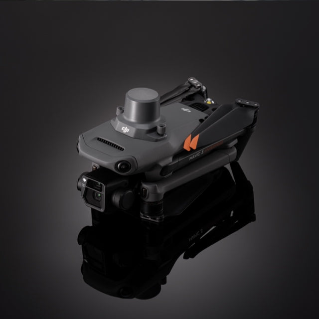
DJI Mavic 3 Enterprise RTK Module
DJI Mavic 3 Enterprise RTK Module

Couldn't load pickup availability


- Description
- Specifications
- In the Box
- FAQ
DJI Mavic 3 Enterprise RTK Module: Professional high-accuracy positioning
The DJI Mavic 3 Enterprise Series RTK Module is a premier add-on accessory that delivers centimeter-level positioning accuracy for demanding industrial drone operations. By attaching this 24-gram module to the top of your Mavic 3 Enterprise or Thermal aircraft, you can perform highly precise aerial surveying without the need for numerous ground control points.
It features multi-constellation support for GPS, GLONASS, BeiDou, Galileo, and QZSS, ensuring reliable signal acquisition in varied environments. This module is an essential tool for professionals in surveying, construction, and precision agriculture who require high-quality, accurately scaled data from a portable platform.
RTK Module features at a glance
- Centimeter-level accuracy: Enables 1cm horizontal and 1.5cm vertical precision
- Lightweight build: Weighs only 24 grams to maximize aircraft endurance
- Multi-system tracking: Supports all major global satellite navigation constellations
- Efficient power use: Consumes only 1.2W during active positioning operations
- Microsecond sync: TimeSync 2.0 aligns image metadata with flight coordinates
- NTRIP compatibility: Works with Network RTK services for wide-area corrections
- Station support: Seamlessly integrates with the DJI D-RTK 2 Mobile Station
- Simple mounting: Attaches securely to the aircraft via built-in thumbscrews
- Mapping optimized: Specifically designed for the DJI Mavic 3 Enterprise Series
Professional accuracy for geospatial data acquisition
The RTK Module provides the uncompromising accuracy required for professional 3D modeling and topographic analysis. By integrating the uncooled VOx microbolometer with the RTK system on the Thermal model, or the mechanical shutter on the Mapping model, the system ensures that every data point is correctly georeferenced.
The module's ability to track multiple frequency points, such as GPS L1/L2 and BDS B1/B2, ensures stable signal reception even in challenging urban environments or near heavy infrastructure. This reliability allows teams to capture high-density datasets with the confidence that their spatial metadata meets industry standards for engineering and construction deliverables.
Hardware, software, and SDK compatibility
- Airframe support: Compatible with DJI Mavic 3 Enterprise and Mavic 3 Thermal
- Primary interface: Connects through the top-mounted USB-C accessory port
- Correction flexibility: Supports D-RTK 2, NTRIP, and custom network RTK
- Software integration: Fully supported by DJI Pilot 2 and DJI Terra
- Positioning systems: Tracks GPS, BDS, GLO, GAL, and QZSS constellations
- Data standards: Exports standard .las files for cross-platform software compatibility
Deployment scenarios
- Surveying missions: Create accurate maps with fewer ground control points
- Construction audits: Monitor site volumes and progress with centimeter-level detail
- Agricultural mapping: Geotag crop health data for precise field management
- Infrastructure safety: Inspect towers and bridges with precise flight path repeatability
- Search and rescue: Maintain accurate search grids in remote or complex terrain
- Disaster response: Map affected areas rapidly with survey-grade spatial accuracy
- Asset management: Track industrial components across large facilities with precision
Designed for enterprise operations
The DJI Mavic 3 Enterprise RTK Module is engineered to be a compact, industry-leading solution that eliminates the logistical burden of traditional surveying. Its foldable design allows the aircraft to remain portable even with the module attached, while the tool-free installation ensures rapid deployment in the field. By providing survey-grade accuracy in a 24-gram package, the RTK module empowers teams to achieve their mission objectives with greater precision and significantly less logistical overhead.
Dronefly serves as your exclusive drone partner, ensuring that your enterprise team is equipped with the most efficient positioning technology available. Our Solutions Lifecycle Partnership Program provides the integrated hardware and software support required to keep your aerial operations accurate and reliable.
Elevate your professional capabilities and achieve your operational goals by choosing the DJI Mavic 3 Enterprise RTK Module from Dronefly.

