Skip to product information
1 of 2

Inertial Labs RESEPI Livox Avia 24MP Camera (FPV Gimbal)

Inertial Labs RESEPI Livox Avia 24MP Camera (FPV Gimbal)

Regular price $17,350.00
Regular price Sale price $17,350.00
Sale Sold out
  • Lightweight under 1 kg for efficient SkyScout fleet operations
  • Livox AVIA delivers up to 720,000 pulses per second
  • Laser range reaches 320m at 80% target reflectivity
  • Vertical accuracy of 3 to 5 cm across all channels
  • RTK at 1 cm plus 1 ppm and PPK at 0.5 cm
  • Tactical-grade IMU-P delivers pitch/roll accuracy of 0.03 degrees
  • Integrated 24MP RGB camera with 70-degree field of view
  • Multi-constellation GNSS supports GPS, GLONASS, Galileo, and BeiDou
  • WiFi interface enables wireless single-operator field deployment
  • Field checks, pre-processing, and post-processing software included
View full details
  • Description
  • Specifications
  • In the Box
  • FAQ

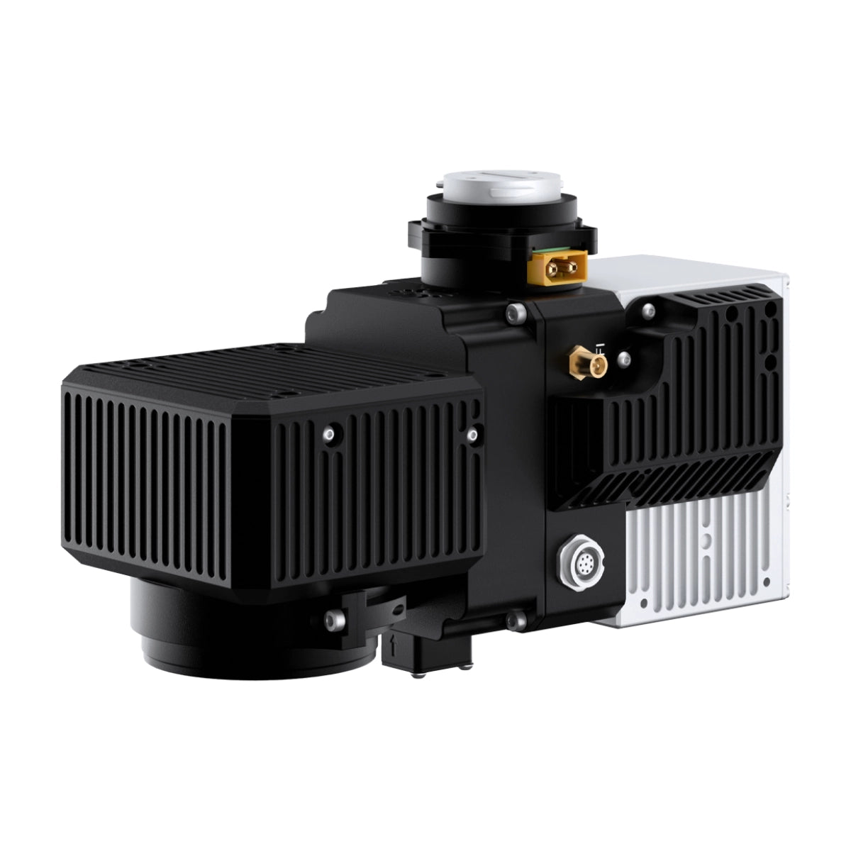
RESEPI Livox AVIA 24MP Camera With FPV Gimbal: Sensor-Fused LiDAR Scanning and Mapping Payload for Enterprise SkyScout Series Programs

The RESEPI Livox AVIA 24MP Camera with FPV Gimbal is a compact, sensor-fused LiDAR scanning and mapping payload built by Inertial Labs in the USA for the WISPR SkyScout Series. At under 1 kg without camera, it is the lightest RESEPI configuration available, designed for enterprise fleet programs where payload weight directly affects operational efficiency and mission endurance.

The narrow vertical field of view concentrates laser measurements for higher ground point density, making it a strong primary sensor for powerline and utility corridor surveys, long-distance land mapping, and high-speed passes over large tracts where point cloud density must be maintained across the full coverage area.

The system integrates the Livox AVIA LiDAR with an Inertial Labs Tactical Grade IMU-P and a high-accuracy single or dual-antenna GNSS receiver supporting GPS, GLONASS, Galileo, BeiDou, QZSS, NavIC, SBAS, and L-Band on L1, L2, and L5 frequencies. RTK and PPK operation modes deliver position accuracy of 1 cm + 1 ppm and 0.5 cm respectively, with system vertical accuracy of 3 to 5 cm tightening to 2 to 3 cm with 1-sigma noise removal.

An integrated 24MP RGB mapping camera with a Sony E-Mount 16mm lens at 70° FOV adds simultaneous color capture to the LiDAR data pipeline. Field checks, pre-processing, and post-processing software are included, with the full system operable via WiFi from a wirelessly connected device through a web interface.

RESEPI Livox AVIA 24MP Mission-Ready Capabilities

  • Lightweight build: under 1 kg without camera supports efficient SkyScout fleet operations.
  • Livox AVIA LiDAR: 6-laser system delivers up to 720,000 pulses per second triple-return.
  • Extended laser range: 190m at 10% and 320m at 80% reflectivity across all channels.
  • System vertical accuracy: 3 to 5 cm, tightening to 2 to 3 cm with 1-sigma noise removal.
  • Dual positioning modes: RTK at 1 cm plus 1 ppm and PPK at 0.5 cm for program flexibility.
  • Tactical-grade IMU-P: pitch/roll accuracy of 0.03° RTK and 0.006° PPK for precise orientation.
  • 24MP RGB camera: Sony E-Mount 16mm lens at 70° FOV enables simultaneous color data capture.
  • Multi-constellation GNSS: GPS, GLONASS, Galileo, BeiDou, QZSS, NavIC, and SBAS supported.
  • Wireless field operation: WiFi interface and web-based control for single-operator deployment.
  • Full software pipeline: field checks, pre-processing, and post-processing software included.

The RESEPI Livox AVIA with 24MP Camera and FPV Gimbal fills a specific role in enterprise SkyScout Series fleet programs: a lightweight LiDAR payload that delivers high point density and survey-grade positional accuracy on missions where sensor weight, corridor geometry, and data throughput all factor into program design.

Its narrow FOV, triple-return pulse capability, and sensor-fused INS pipeline make it a dependable primary sensor for powerline inspection, utility corridor mapping, and large-area land survey programs that require both LiDAR and RGB data from a single deployable system.

Dronefly carries the RESEPI Livox AVIA 24MP Camera with FPV Gimbal for the WISPR SkyScout Series, including the complete system with 256 GB USB storage and full software pipeline.

Order the RESEPI Livox AVIA at Dronefly today.

General Specifications

  • System vertical accuracy: 3–5 cm
  • Precision: 4–5 cm
  • Precision (1σ noise removal): 2–3 cm
  • Recommended AGL: Up to 85 m
  • Weight: 1.2 kg (with camera), 0.9 kg (without camera)
  • Dimensions: 20 × 13 × 9.2 cm
  • Max flight time (DJI M300): 33 minutes
  • External storage: 256 GB USB included
  • System computer: Quad-core CPU, 1 GB RAM, 8 GB eMMC
  • Operating voltage: 9–45 V
  • Power consumption: 16 W

LiDAR

  • Laser range: 190 m @ 10% reflectivity; 320 m @ 80% reflectivity
  • Range accuracy: ±2 cm
  • Horizontal field of view: 70.4°
  • Vertical field of view: 4.5° / 77.2°
  • Beam divergence: 0.03° (H), 0.28° (V)
  • Laser channels: 6
  • Returns: Up to 3
  • Pulse rate: 240k pts/s (single), 480k pts/s (dual), 720k pts/s (triple)

GPS-Aided INS

  • IMU: Inertial Labs Tactical Grade IMU-P
  • GNSS: Single or dual antenna
  • Supported constellations: GPS, GLONASS, Galileo, BeiDou, QZSS, NavIC (IRNSS), SBAS, L-Band
  • Supported frequencies: L1, L2, L5
  • Operation modes: RTK and PPK
  • Output rates: Up to 200 Hz (INS), up to 2,000 Hz (IMU)
  • Pitch/Roll accuracy: 0.03° (RTK), 0.006° (PPK)
  • Heading accuracy: 0.15° (RTK), 0.03° (PPK)
  • Velocity accuracy: <0.03 m/s
  • Position accuracy: 1 cm + 1 ppm (RTK), 0.5 cm (PPK)

Camera

  • Camera: 24 MP RGB mapping camera
  • Lens: Sony E-Mount 16 mm, 70° FOV
  • Maximum trigger rate: 2 seconds
  • External camera support: Yes

Software

  • Field checks: Included
  • Pre-processing: Included
  • Post-processing: Supported
  • 1x Inertial Labs RESEPI Livox Avia 24MP Camera (FPV Gimbal)
What enterprise use cases is the RESEPI Livox AVIA best suited for?

The RESEPI Livox AVIA is purpose-suited for powerline and utility corridor surveys, large-area land mapping, and high-speed passes where point cloud density must be preserved across the full coverage area. Its narrow vertical field of view concentrates laser measurements along linear features, making thin objects like utility lines more distinguishable in point cloud data. The lightweight build under 1 kg without camera also makes it a practical choice for SkyScout Series fleet programs where payload weight affects operational efficiency across multi-mission days.

What LiDAR range and accuracy does the RESEPI Livox AVIA deliver?

The Livox AVIA LiDAR reaches 190m at 10% target reflectivity and 320m at 80% reflectivity across all channels, with a range accuracy of +/- 2 cm. System vertical accuracy is 3 to 5 cm, tightening to 2 to 3 cm with 1-sigma noise removal. The recommended operating altitude is up to 85 m AGL for optimal point cloud density and positional accuracy across program-grade survey deliverables.

What INS and GNSS capabilities does the RESEPI Livox AVIA provide for enterprise programs?

The system integrates an Inertial Labs Tactical Grade IMU-P with single or dual-antenna GNSS supporting GPS, GLONASS, Galileo, BeiDou, QZSS, NavIC, SBAS, and L-Band on L1, L2, and L5 frequencies. INS output rates reach up to 200Hz and IMU rates up to 2,000Hz. Position accuracy is 1 cm + 1 ppm in RTK mode and 0.5 cm in PPK mode, with pitch/roll accuracy of 0.03° RTK and 0.006° PPK, supporting the positioning precision that survey-grade fleet programs require.

What RGB imaging capability does the RESEPI Livox AVIA include?

The system integrates a 24MP RGB mapping camera with a Sony E-Mount 16mm lens at a 70° field of view, enabling simultaneous color data capture alongside the LiDAR point cloud. This supports colorized point cloud outputs and RGB-LiDAR fusion deliverables for inspection, corridor mapping, and survey programs that require both spatial and color data from a single payload deployment.

What software and storage does the RESEPI Livox AVIA ship with?

The system includes 256 GB USB external storage and a complete software pipeline covering field checks, pre-processing, and post-processing. The RESEPI platform runs on a Linux-based processing core with a Quad Core processor, 1GB RAM, and 8GB eMMC. It can be operated via a single hardware button or wirelessly through a web interface from a connected device, supporting single-operator deployment without a dedicated ground station computer on site.