Skip to product information
1 of 3

Inertial Labs RESEPI Ouster REV7 OS1-64 26MP Camera (FPV Gimbal)

Inertial Labs RESEPI Ouster REV7 OS1-64 26MP Camera (FPV Gimbal)

Regular price $49,725.00
Regular price Sale price $49,725.00
Sale Sold out
  • NDAA-compliant LiDAR payload for secure enterprise fleet programs
  • 64-channel Ouster OS1-64 REV7 delivers 2,621,000 pulses per second
  • Full 360-degree horizontal and 45-degree vertical field of view
  • Laser range reaches 90m at 10% target reflectivity
  • Vertical accuracy of 3 to 5 cm across all channels
  • NovAtel OEM7720 GNSS supports PPK positioning accuracy of 0.5 cm
  • Tactical-grade IMU-P delivers pitch/roll accuracy of 0.006 degrees
  • Integrated 24MP RGB camera with Sony E-Mount 16mm lens
  • WiFi interface supports wireless single-operator fleet deployment
  • Field checks, pre-processing, and post-processing software included
View full details
  • Description
  • Specifications
  • In the Box
  • FAQ

RESEPI Ouster REV7 OS1-64 24MP Camera: NDAA-Compliant 64-Channel LiDAR Scanning and Mapping Payload for Enterprise SkyScout Series Programs

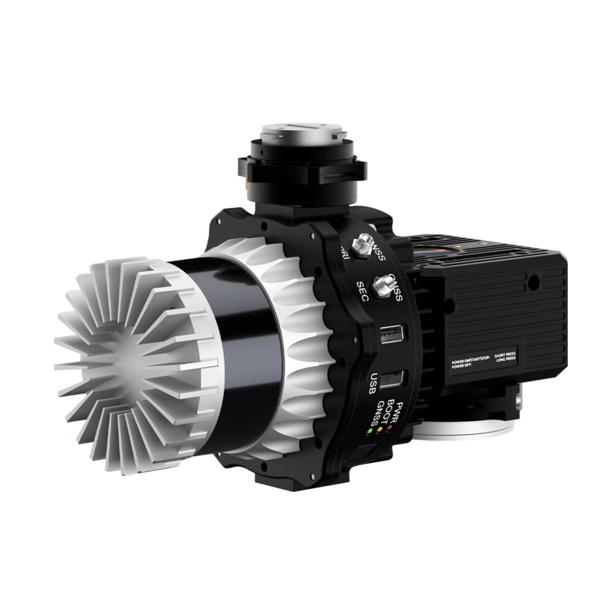
The RESEPI Ouster REV7 OS1-64 24MP Camera is a professional, NDAA-compliant sensor-fused LiDAR scanning and mapping payload built by Inertial Labs in the USA for the WISPR SkyScout Series.

Integrating the Ouster OS1-64 REV7 LiDAR with an Inertial Labs Tactical Grade IMU-P and a NovAtel OEM7720 GNSS receiver, it delivers a complete aerial scanning system engineered for georeferenced 3D point cloud data collection across government, utilities, construction, and infrastructure programs where data security and supply chain compliance are operational requirements. 

At 1.4 kg with camera, it balances sensor capability and payload weight for sustained SkyScout Series fleet operations across mapping, surveying, powerline inspection, and precision agriculture missions.

The OS1-64 REV7 LiDAR delivers a full 360° horizontal field of view with a 45° vertical FOV, capturing up to 2,621,000 pulses per second in dual-return mode across 64 laser channels. Laser range reaches 90m at 10% reflectivity and up to 200m at higher reflectivity targets, with a range accuracy of +/- 2.5 cm and a recommended operating altitude of up to 100 m AGL.

System vertical accuracy is 3 to 5 cm, tightening to 2 to 4 cm with 1-sigma noise removal. An integrated 24MP RGB mapping camera with a Sony E-Mount 16mm lens at 70° FOV adds simultaneous color capture to the point cloud pipeline. PPK positioning delivers 0.5 cm position accuracy, with pitch/roll accuracy of 0.006° and heading accuracy of 0.03° for precise trajectory reconstruction across multi-pass fleet missions.

RESEPI Ouster REV7 OS1-64 24MP Mission-Ready Capabilities

  • NDAA-compliant: secure component sourcing supports government and regulated enterprise programs.
  • 64-channel LiDAR: Ouster OS1-64 REV7 delivers up to 2,621,000 pulses per second dual-return.
  • Full 360° horizontal FOV: 45° vertical field of view supports wide-area terrain and structure mapping.
  • Extended laser range: 90m at 10% reflectivity and up to 200m at higher reflectivity across channels.
  • System vertical accuracy: 3 to 5 cm, tightening to 2 to 4 cm with 1-sigma noise removal applied.
  • NovAtel OEM7720 GNSS: high-accuracy receiver supports PPK at 0.5 cm for program-grade positioning.
  • Tactical-grade IMU-P: pitch/roll accuracy of 0.006° PPK sustains trajectory precision across missions.
  • 24MP RGB camera: Sony E-Mount 16mm lens at 70° FOV delivers simultaneous color point cloud data.
  • Wireless fleet operation: WiFi interface and web-based control supports single-operator deployment.
  • Complete software pipeline: field checks, pre-processing, and post-processing software included.

The RESEPI Ouster REV7 OS1-64 24MP Camera addresses the core requirements of enterprise LiDAR programs on the SkyScout Series: NDAA-compliant component sourcing, high-density 64-channel point cloud capture, survey-grade positional accuracy via PPK, and simultaneous RGB imaging from a single deployable payload.

For fleet operators running government, utilities, infrastructure, or construction programs where data security and output consistency are non-negotiable, this system delivers the sensor fusion architecture and software pipeline to support repeatable, production-ready results.

Dronefly carries the RESEPI Ouster REV7 OS1-64 24MP Camera for the WISPR SkyScout Series, including the complete system with 256 GB USB storage and full software pipeline.

Order the RESEPI Ouster REV7 OS1-64 24MP Camera at Dronefly today.

System Specifications

  • System vertical accuracy (5 m/s @ 50 m): 3–5 cm
  • Precision: 4–6 cm
  • Precision (1σ noise removal): 2–4 cm
  • Recommended AGL: 100 m
  • Weight: 1.4 kg with camera (1.0 kg without camera)
  • Dimensions: 20.6 × 16.5 × 14.2 cm
  • Maximum flight time: 33 minutes (DJI M300)
  • Storage: 256 GB external storage (USB included)
  • System computer: Quad-core processor, 1 GB RAM, 8 GB eMMC
  • Operational voltage: 9–45 V
  • Power consumption: 41 W

LiDAR Scanner

  • Laser range: 90 m @ 10% reflectivity (all channels), 0.5–200 m
  • Range accuracy: ±2.5 cm
  • Horizontal field of view: 360°
  • Vertical field of view: 45°
  • Vertical scan angle: -22.5° to 22.5°
  • Beam divergence: 0.18° (horizontal), 0.18° (vertical)
  • Number of lasers: 64
  • Number of returns: 2
  • Pulse rate: 2,621,000 points per second (dual return)

Camera

  • Model: 24 MP RGB Mapping Camera
  • Lens: Sony E-Mount 16 mm, 70° field of view
  • Maximum trigger rate: 2 seconds
  • External camera support: Yes

GPS-Aided INS

  • IMU: Inertial Labs Tactical Grade IMU-P
  • GNSS: Single or Dual Antenna
  • Supported constellations: GPS, GLONASS, Galileo, BeiDou, QZSS, NavIC (IRNSS), SBAS, L-Band
  • Supported frequencies: L1, L2, L5
  • Operation modes: RTK and PPK
  • Output rates: Up to 200 Hz (INS), Up to 2,000 Hz (IMU)
  • Pitch/Roll accuracy: 0.03° (RTK), 0.004° (PPK)
  • Heading accuracy: 0.1° (RTK), 0.02° (PPK)
  • Velocity accuracy: <0.03 m/s
  • Position accuracy: 1 cm + 1 ppm (RTK), 0.5 cm (PPK)

Software

  • Field checks: Included
  • Pre-processing: Included
  • Post-processing: Supported
  • 1x Inertial Labs RESEPI Ouster REV7 OS1-64 26MP Camera (FPV Gimbal)
What makes the RESEPI Ouster REV7 OS1-64 24MP Camera suited for enterprise and government fleet programs?

The payload is NDAA-compliant, supporting secure component sourcing and protected geospatial workflows for government agencies, utilities operators, and regulated industries where supply chain transparency is a program requirement. Integrated directly with the NDAA-compliant WISPR SkyScout Series, it provides a fully compliant aerial LiDAR platform for programs where both the drone and sensor must meet federal procurement and data security standards.

What LiDAR performance does the RESEPI Ouster REV7 OS1-64 deliver for fleet operations?

The Ouster OS1-64 REV7 features 64 laser channels with a full 360° horizontal field of view and a 45° vertical FOV. It captures up to 2,621,000 pulses per second in dual-return mode, with a laser range of 90m at 10% target reflectivity and up to 200m at higher reflectivity. Range accuracy is +/- 2.5 cm. The recommended operating altitude is up to 100 m AGL, supporting efficient large-area coverage across multi-pass fleet missions.

What positioning accuracy does the RESEPI Ouster REV7 OS1-64 24MP Camera achieve?

The system integrates an Inertial Labs Tactical Grade IMU-P with a NovAtel OEM7720 GNSS receiver supporting GPS, GLONASS, Galileo, BeiDou, QZSS, NavIC, SBAS, and L-Band on L1, L2, and L5 frequencies. PPK positioning delivers 0.5 cm position accuracy, with pitch/roll accuracy of 0.006° and heading accuracy of 0.03°. RTK mode delivers 1 cm + 1 ppm position accuracy with 0.03° pitch/roll. INS output rates reach up to 200Hz and IMU rates up to 2,000Hz for high-rate trajectory reconstruction across fleet missions.

What system accuracy does the RESEPI Ouster REV7 OS1-64 achieve and how does noise removal affect it?

System vertical accuracy is 3 to 5 cm under standard conditions, tightening to 2 to 4 cm with 1-sigma noise removal applied in post-processing. Precision without noise removal is 4 to 6 cm. These figures are based on single-pass test conditions at 50 m AGL at 5 m/s nadir. The complete software pipeline covering field checks, pre-processing, and post-processing is included to support consistent accuracy across program-scale deployments.

What RGB imaging and data handling capabilities does the system provide for enterprise programs?

The system integrates a 24MP RGB mapping camera with a Sony E-Mount 16mm lens at a 70° field of view, enabling simultaneous color data capture for colorized point cloud outputs and RGB-LiDAR fusion deliverables. External storage is provided via 256 GB USB. The Linux-based processing core runs on a Quad Core processor with 1GB RAM and 8GB eMMC, and can be operated via a single hardware button or wirelessly through a web interface, supporting single-operator deployment across fleet operations without a dedicated ground station computer on site.