Skip to product information
1 of 11

WISPR 24MP Mapper Payload

WISPR 24MP Mapper Payload

Regular price $5,500.00
Regular price Sale price $5,500.00
Sale Sold out
SKU S-WSP-MAP-24MP-SS MPN 2100.005.018
  • Sony Exmor APS-C CMOS delivers 24-megapixel aerial imaging output
  • 6000 x 4000 resolution feeds directly into photogrammetry pipelines
  • 83-degree FOV reduces required passes over large survey areas
  • 3-axis gimbal maintains ±0.02° vibration range across all flight dynamics
  • Dual geotagging via EXIF and GPSlog.txt captures complete positional datasets
  • Horizontal and vertical accuracy logged separately for processing integrity
  • RAW, HEIF, and JPEG formats support varied enterprise deliverable requirements
  • Video subtitle file logs positional data at one data point per second
  • Quick-attach twist-lock ring supports consistent multi-mission payload swaps
  • ISO expandable to 51200 with MFNR for low-light mission capability
View full details
  • Description
  • Specifications
  • In the Box
  • FAQ

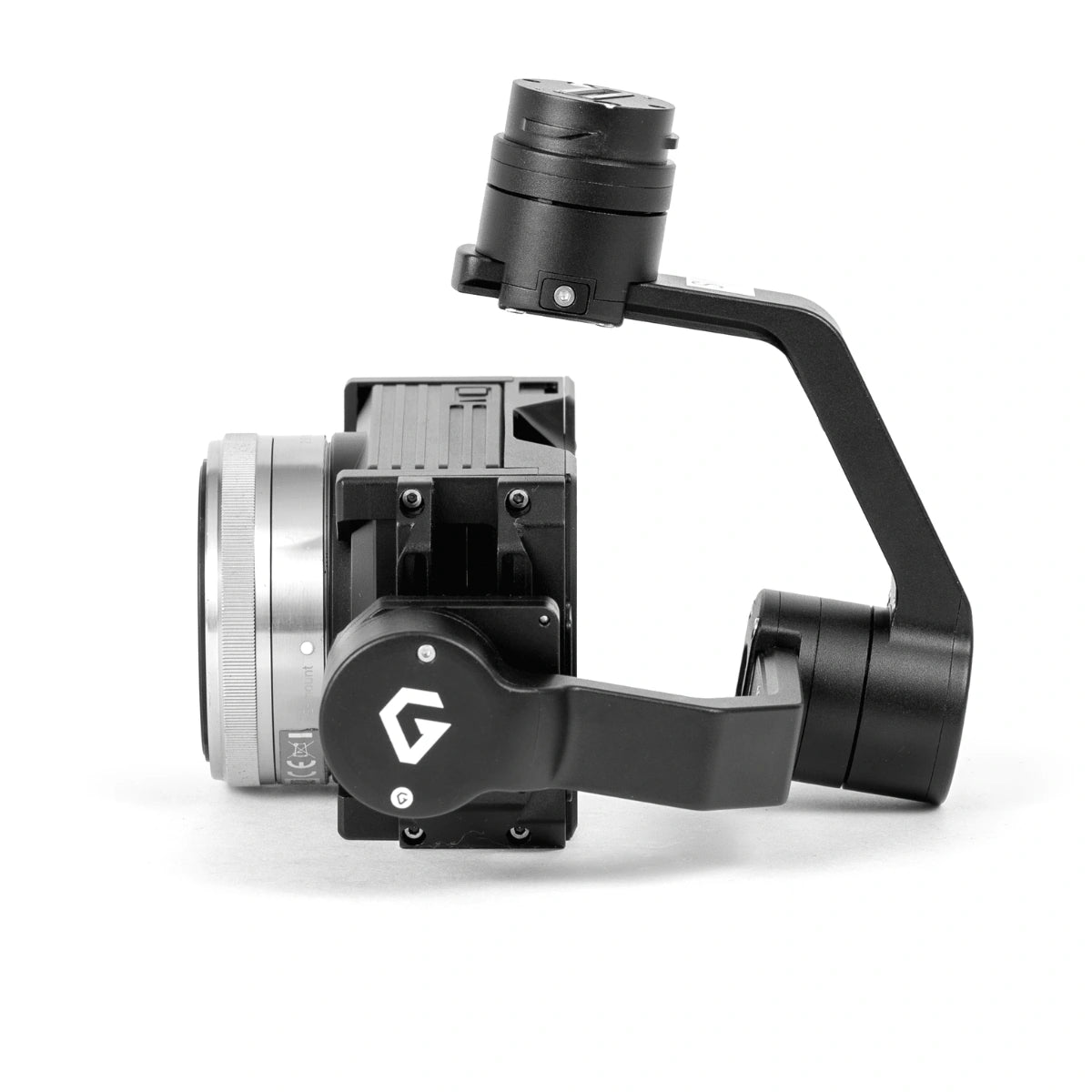
WISPR 24MP Mapper: APS-C Mapping Payload With Integrated Geotagging for the SkyScout 2 Series

The WISPR 24MP Mapper is a gimbal-mounted imaging payload purpose-built for enterprise aerial data collection on the WISPR SkyScout 2 Series. At its core is a Sony Exmor APS-C CMOS sensor delivering 24-megapixel output at 6000 x 4000 pixels through a Sony E Mount 16mm lens with an 83-degree field of view — a configuration that balances ground resolution with area coverage across mapping, surveying, and photogrammetry deployments. The twist-lock quick-attach gimbal ring integrates directly with the SkyScout 2 payload interface, keeping swap times short and operational continuity intact across multi-payload programs.

For fleet operators and program managers, the 24MP Mapper's data pipeline is as important as its imaging specs. Every image capture writes a full geotag to EXIF — latitude, longitude, altitude, gimbal yaw, pitch, and roll, plus GPS timestamp — while a parallel GPSlog.txt file records horizontal and vertical accuracy values not embedded in EXIF. Video missions generate a frame-accurate subtitle file logging positional data at one data point per second. Shooting in RAW, HEIF, or JPEG, with ISO expandable to 51200 via MFNR and a mechanical shutter range of 1/4000 to 30 seconds, the payload adapts to the lighting and output conditions your workflows demand.

Mission-Ready Capabilities of the WISPR 24MP Mapper

  • APS-C CMOS sensor: 1.11-inch Sony Exmor delivers enterprise-grade aerial image quality.
  • Full-resolution output: 6000 x 4000 pixel capture feeds directly into photogrammetry pipelines.
  • Wide-field lens: 83-degree FOV reduces required passes over large survey areas.
  • Stabilized 3-axis gimbal: ±0.02° vibration range keeps imagery sharp through flight dynamics.
  • Dual geotagging system: EXIF and GPSlog.txt together capture complete positional datasets.
  • Accuracy data backup: horizontal and vertical accuracy logged separately for processing integrity.
  • Flexible format support: RAW, HEIF, and JPEG accommodate varied deliverable requirements.
  • Video geotag pipeline: subtitle file writes positional data at one data point per second.
  • High-ISO capability: sensitivity to 51200 with MFNR extends usability in low-light conditions.
  • Integrated mount system: quick-attach ring supports consistent multi-mission payload deployment.

The WISPR 24MP Mapper addresses a persistent gap in enterprise drone programs: a high-resolution imaging payload that produces geospatially complete datasets without additional hardware or post-processing workarounds. The 3-axis gimbal's controlled pan range of ±320° and operating temperature envelope of 32°F to 122°F (0°C to 50°C) support sustained deployment across diverse mission environments and fleet configurations.

Dronefly specializes in building integrated UAV solutions for enterprise operators who need payloads that perform consistently across program-scale deployments. Our team can help you configure the WISPR 24MP Mapper within your SkyScout 2 Series fleet and ensure your data collection workflow is production-ready from day one. Contact Dronefly to get started.

Camera

  • Sensor: Exmor APS-C CMOS
  • Sensor size: 1.11"
  • Sensor width: 0.93"
  • Sensor height: 0.61"
  • Photo resolution: 24 MP
  • Image size: 6000 × 4000
  • Photo formats: JPEG, HEIF, RAW
  • Video resolution: 1080p at 60 fps (max)
  • Video formats: XAVC S (MPEG-4 AVC/H.264), AVCHD 2.0, MP4
  • Shutter type: Mechanical shutter / Electronic shutter
  • Shutter speed: 1/4000 s to 30 s (still images, mechanical shutter)
  • Exposure compensation: ±5.0 EV in 0.3 EV steps
  • ISO sensitivity: Auto, 100, 200, 400, 800, 1600, 3200, 6400, 12800, 25600; 51200 available with MFNR
  • PAL/NTSC: Supported

Camera Lens

  • Lens option: Sony E-Mount 16 mm lens
  • Field of view (FOV): 83°

Gimbal

  • Angular vibration range: ±0.02°
  • Maximum controlled rotation speed: Pan 180°/s, Tilt 180°/s, Roll 180°/s
  • Mechanical endpoint range: Pan ±326°, Tilt +45° to -125°, Roll +45° to -45°
  • Controlled rotation range: Pan ±320°, Tilt +40° to -120°, Roll ±40°
  • Operating temperature: 32°F to 122°F
  • 1x WISPR 24MP Mapper Payload
What drone platform is the WISPR 24MP Mapper designed for?

The WISPR 24MP Mapper is built for integration with the WISPR SkyScout 2 Series. It connects via a twist-lock quick-attach gimbal ring that interfaces directly with the SkyScout 2 payload mount. The tool-free installation process — align, insert, and rotate clockwise to lock — keeps deployment times short across multi-payload fleet configurations.

How does the dual geotagging system work on the WISPR 24MP Mapper?

The payload writes geotag data through two parallel channels. EXIF data embedded in each image captures latitude, longitude, altitude, gimbal yaw, pitch, roll, and GPS timestamp. A separate GPSlog.txt file records the same positional fields plus horizontal and vertical accuracy, which are not written to EXIF. Both outputs use WGS84 horizontal projection and Ellipsoid vertical projection, measured in meters.

What image formats does the WISPR 24MP Mapper support for enterprise workflows?

The payload captures in JPEG, HEIF, and RAW formats. RAW output is particularly relevant for photogrammetry and survey-grade mapping programs where full uncompressed sensor data is required for accurate 2D orthomosaic and 3D model generation. Format selection can be matched to the downstream processing platform and deliverable specification.

What are the gimbal capabilities of the WISPR 24MP Mapper?

The payload uses a 3-axis stabilized gimbal with an angular vibration range of ±0.02°. Controlled rotation ranges are ±320° pan, +40° to -120° tilt, and ±40° roll, with a maximum rotation speed of 180°/s across all axes. The operating temperature range of 32°F to 122°F (0°C to 50°C) supports sustained deployment across varied field environments.

Does the WISPR 24MP Mapper support geotagged video for enterprise data programs?

Yes. The payload records video at up to 1080P at 60fps in XAVC S (MPEG-4 AVC/H.264) or AVCHD 2.0/MP4. When video geotagging is enabled in WISPR Ground Control, a subtitle file in .ass format is written to a microSD card in the smart controller, logging latitude, longitude, altitude, heading, and timestamp at one data point per second — providing a continuous positional record for the full duration of each video mission.