
WISPR SkyScout 2 with Black Herelink
WISPR SkyScout 2 with Black Herelink

Couldn't load pickup availability
- Description
- Specifications
- In the Box
- FAQ
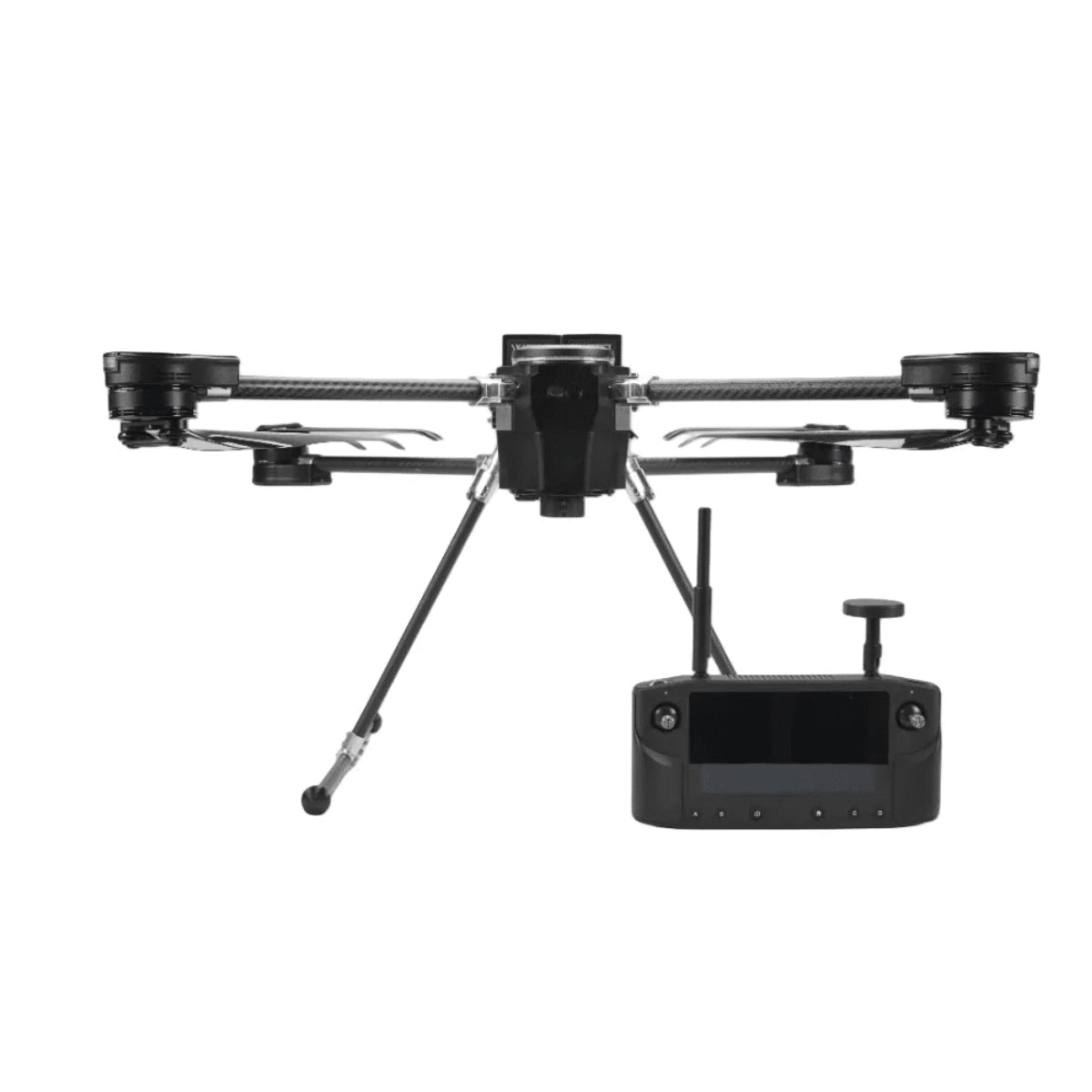
WISPR SkyScout 2 with Herelink Black Controller: Blue UAS Approved Quadcopter for Enterprise Aerial Data Programs
The WISPR SkyScout 2 is a domestically produced, foldable quadcopter platform built for enterprise UAS programs that require verifiable positioning accuracy, flexible payload integration, and fleet-ready compliance. Powered by a Cube Orange+ flight controller running custom WISPR firmware, it supports both RTK and PPK geotagging workflows, carries up to 3.85 lbs. of sensor payload, and operates across a temperature range of -4°F to 122°F, covering the full spectrum of conditions encountered across inspection, mapping, and public safety deployments.
Paired with the Herelink Black controller, this bundle delivers a compact and proven ground control unit purpose-built for professional drone operations. The Herelink Black features a 5.5-inch LCD screen at 1000 nits brightness, transmits 1080p video at 30fps over 2.4GHz LTE at up to 12 miles, and secures all data links with AES128 encryption and dual antennas. For program managers building out compliant, scalable drone fleets, the SkyScout 2 with Herelink Black represents a purpose-built, NDAA Section 848 approved system ready for immediate operational deployment.
Key Features and Benefits
- Blue UAS and NDAA compliance: Blue UAS approved and NDAA Section 848 compliant for federal, defense, and critical infrastructure fleet integration.
- RTK geotagging: real-time sub-centimeter positioning via NTRIP or RTCM correction services included as standard.
- Hot-swap batteries: 4350mAh field-swappable packs charge in 45 minutes and support automated mission resume without powering down.
- Payload capacity: 3.85 lb. maximum sustainable payload accommodates RGB, multispectral, thermal, and LiDAR sensor packages.
- Wind resistance: 50 MPH max wind rating maintains stable data collection in exposed or high-wind operating environments.
- Collision avoidance: LiDAR TOF sensors provide front, rear, and downward protection with PathGuard detection up to 164 ft.
- TempGuard system: dual active and passive thermal regulation sustains component performance in temperature extremes.
- SignalShield protection: integrated EMI shielding maintains link integrity near power lines, substations, and cell towers.
- TerrainSense follow: GNSS and LiDAR-based terrain following enables consistent low-altitude data capture across variable terrain.
- Foldable airframe: 4.5" x 10" x 17" folded profile deploys from a carry-on sized case for rapid site-to-site repositioning.
A Compliant Platform Built for Program Scale
Enterprise UAS programs live or die on three variables: data accuracy, operational continuity, and procurement compliance. The SkyScout 2 addresses all three within a single, carry-on portable airframe. Its Ublox ZED-F9P GNSS receiver tracks L1, L2, and E5 bands across GPS, Galileo, GLONASS, and BeiDou constellations, delivering the positioning foundation that survey-grade workflows demand. The SmartCore power distribution system manages both batteries in parallel with redundant protection and real-time health monitoring, while the Battery Management System issues predictive alerts before degradation affects mission output. For fleet integrators evaluating platforms against federal procurement requirements, the SkyScout 2 carries both Blue UAS approval and full NDAA Section 848 compliance, fully sourced from approved vendors with no restricted foreign technology in the stack.
Compatibility and System Integration
- Cube Orange+ flight controller: runs WISPR Flight Firmware on an ArduPilot and PX4 compatible platform (included).
- Herelink Black controller: integrated RC control, 1080p video transmission, and telemetry in a single NDAA-compliant unit (included).
- WISPR Smart Batteries: two 4350mAh hot-swappable LiPo packs with full BMS protection (included, 1 pair).
- WISPR 110V battery charger: field-ready charging solution for WISPR Smart Batteries (included).
- WISPR Ground Control: mission planning software with payload-specific speed and parameter profiles (included).
- WISPR Cloud: required for PPK subscription and cloud-based mission data management (sold separately).
- Gremsy Vio and Zio gimbals: compatible via S-Port quick-attach system with no wiring required (sold separately).
- RESEPI and YellowScan LiDAR systems: natively supported within WISPR Ground Control payload profiles (sold separately).
- GeoCue TrueView and T1 LiDAR: supported payload options within WISPR Ground Control (sold separately).
- ILX-LR1 and WISPR 24MP Mapper cameras: supported RGB mapping payloads for photogrammetry workflows (sold separately).
Applications and Use Cases
- Enterprise survey programs: RTK and PPK geotagging support centimeter-accurate deliverables across large-area mapping contracts.
- Federal and defense fleet acquisition: Blue UAS approval and NDAA Section 848 compliance satisfy procurement requirements at the program level.
- Infrastructure inspection programs: foldable airframe and 50 MPH wind rating keep multi-site inspection schedules on track at towers, lines, and substations.
- LiDAR integration workflows: dedicated starboard GNSS antenna mount captures raw GNSS data for point cloud accuracy across supported LiDAR payloads.
- Public safety agencies: pre-configured Remote ID and sub-3-minute deployment support time-critical field response without setup delays.
- Agricultural data services: 3.85 lb. payload capacity supports multispectral and thermal sensors across high-volume area coverage programs.
- Multi-crew field operations: hot-swappable batteries and carry-on sized case allow rapid redeployment across teams and sites within a single operational day.
The SkyScout 2 is a production-ready platform for enterprise programs that require accuracy, compliance, and operational continuity across diverse mission types. Its domestically produced airframe, survey-grade GNSS stack, and broad payload compatibility make it one of the most versatile compact drones available for professional fleet deployment.
Dronefly brings years of UAS industry experience to every customer relationship, with deep expertise in enterprise integration, payload configuration, and program-level fleet support. When you source the WISPR SkyScout 2 with Herelink Black through Dronefly, you gain a solutions partner invested in the long-term performance of your program. Configure your system and order today at Dronefly.

